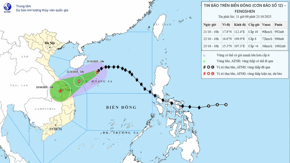
According to updated data, the storm's center may make landfall in the Da Nang - Quang Ngai area before weakening into a tropical depression. Previously, meteorological agencies predicted that the storm might weaken into a tropical depression before making landfall.
Specifically, at 10:00 AM on the same day, the storm's center was located at approximately 17.8 degrees North latitude and 112.4 degrees East longitude, about 125km north of the Hoang Sa (Paracel) Islands. The strongest winds near the storm's center remained at level 9-10 (75-102 km/h), with gusts up to level 12. At this time, the storm was moving southwest at a speed of 10-15 km/h.
The National Center for Meteorological and Hydrological Forecasting predicts that over the next 24 to 48 hours, the storm will continue to move southwest at a speed of 10-15 km/hour, but with wind speeds still at level 8, gusting to level 10.
Then, from October 22nd to the morning of October 23rd, the storm continued to move southwest at a speed of 10-15 km/hour, making landfall in the Da Nang - Quang Ngai area, weakening into a tropical depression and then a low-pressure area.
The meteorological agency continues to warn of the risk of very heavy and prolonged rainfall in the central region until the end of October. The rain is caused by the influence of the storm's circulation combined with cold air and easterly winds, and topographic effects. From the night of October 22nd to 27th, the area from Ha Tinh to Quang Ngai will experience widespread heavy rain. Specifically, Ha Tinh - northern Quang Tri and Quang Ngai: 200-400mm, with some areas exceeding 500mm; southern Quang Tri - Da Nang: 500-700mm, with some areas exceeding 900mm.
Source: https://www.sggp.org.vn/tam-bao-co-the-do-bo-dat-lien-trung-bo-post819136.html


![[Image] National Conference on studying, understanding, and implementing Resolutions No. 79 and No. 80 of the Politburo](https://vphoto.vietnam.vn/thumb/402x226/vietnam/resource/IMAGE/2026/02/25/1771990845625_anh-man-hinh-2026-02-25-luc-10-40-34.png)


Comment (0)