


Updated position of storm No. 5 at 2:00 p.m. on August 25. Source: Vietnam Disaster Monitoring System
Latest update from the National Center for Hydro-Meteorological Forecasting, due to the influence of storm No. 5, at Bach Long Vi station ( Hai Phong ) there are strong winds of level 7, gusts of level 9; Co To station (Quang Ninh) there are strong winds of level 7, gusts of level 10; Bai Chay station (Quang Ninh) there are strong winds of level 6, gusts of level 8; Van Ly station (Ninh Binh) there are strong winds of level 8, gusts of level 9.
Dien Chau station ( Nghe An ) has strong winds of level 7, gusts of level 9; Quynh Luu station (Nghe An) has strong winds of level 7, gusts of level 12; Hon Ngu station (Nghe An) has strong winds of level 8, gusts of level 11.
Hoanh Son station ( Ha Tinh ) has strong winds of level 7, gusts of level 9; Ky Anh station (Ha Tinh) has strong winds of level 7, gusts of level 11; Cam Nhuong station (Ha Tinh) has gusts of level 8; Con Co station (Quang Tri) has strong winds of level 6, gusts of level 8.
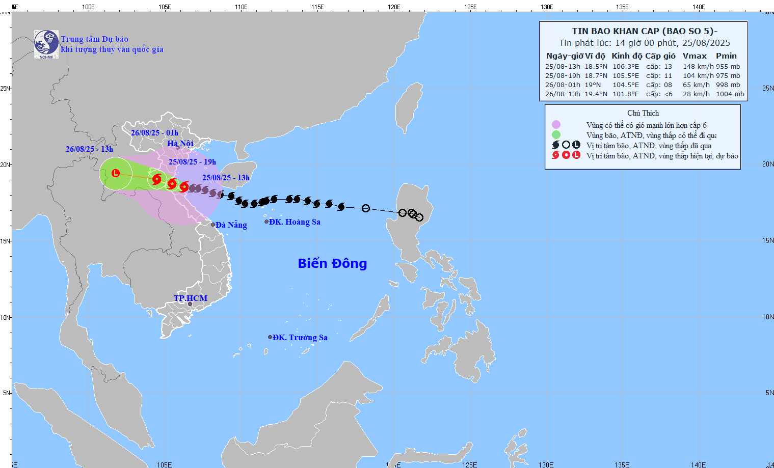
Updated location and path of storm No. 5 Kajiki at 2:00 p.m. on August 25. Source: National Center for Hydro-Meteorological Forecasting
Storm surge in Sam Son (Thanh Hoa) 0.91m, Hon Ngu (Nghe An) 1.45m, Vung Ang (Ha Tinh) 0.51m. In the Northern Delta provinces and from Thanh Hoa to Quang Tri, there has been moderate to heavy rain, in some places very heavy rain over 300mm.
Storm No. 5 decreased by 1 level, strong level 13, gust level 16

Mr. Mai Van Khiem provides updated information on storm No. 5. Photo: Vu Linh
According to Mr. Mai Van Khiem - Director of the National Center for Hydro-Meteorological Forecasting, the intensity of storm No. 5 Kajiki has tended to decrease but is still very strong.
At 1 p.m. on August 25, the eye of the storm was located at approximately 18.5 degrees north latitude; 106.3 degrees east longitude, in the coastal waters of Nghe An - Ha Tinh. The strongest wind near the eye of the storm was level 13 (134-149 km/h), gusting to level 16; moving west-northwest at a speed of 15-20 km/h.
"The storm will start making landfall around 3pm to 7pm. Landfall area: South Thanh Hoa-Ha Tinh, focusing on Nghe An province" - Mr. Khiem said.
Forecast in the next 6 hours, the storm moves west-northwest at a speed of 15-20km/hour.
At 7:00 p.m. on August 25, the center of the storm was at approximately 18.7 degrees north latitude; 105.5 degrees east longitude, on the mainland of Thanh Hoa - Ha Tinh provinces. Wind force level 10-11, gust level 13.
The danger zone is the 16.5-20.5 degree north latitude; west of the 109.5 degree east longitude. Level 3 natural disaster risk in the northern Gulf of Tonkin, the sea area from Thanh Hoa to Quang Tri (including Hon Ngu island, Con Co special zone). Level 4 natural disaster risk in the coastal waters and mainland of the provinces from southern Thanh Hoa to northern Ha Tinh.
Forecast in the next 12 hours , the storm continues to move west-northwest at a speed of 15-20km/hour.
At 1:00 a.m. on August 26, the center of the storm was at about 19 degrees north latitude; 104.5 degrees east longitude, on the Vietnam - Laos border. Wind force was level 8, gusting to level 10. The dangerous area was latitude 16.5-20.5 degrees north latitude; west of longitude 108.5 degrees east longitude. Disaster risk level 3 in the northern Gulf of Tonkin and the sea area from Thanh Hoa to Quang Tri (including Hon Ngu island, Con Co special zone).
In the next 24 hours, the storm is forecast to move west-northwest at about 20km/h, gradually weakening into a low pressure area. At 1pm on August 26, it will be located at about 19.4 degrees north latitude; 101.8 degrees east longitude, in the Central Laos region. Wind force below level 6.
The most dangerous area is within a 50km radius of the storm center.
According to the Director of the Meteorological Agency, on land, the North of Thanh Hoa has strong winds of level 8-9, gusting to level 10-11. The South of Thanh Hoa - the North of Ha Tinh has strong winds of level 10-11, the area near the storm's center has winds of level 12-13, gusting to level 14-15. The South of Ha Tinh, Quang Tri and the coastal provinces from Quang Ninh to Ninh Binh have strong winds of level 6-8, gusting to level 9-10.
"The most dangerous area is within a 50 km radius around the storm's center, with winds of level 12 or higher. The directly affected area includes northern Ha Tinh, Nghe An, and southern Thanh Hoa; special attention should be paid to Vinh city, coastal tourist areas such as Cua Lo, Cua Hoi, old Nghi Xuan (Ha Tinh) and neighboring communes," Mr. Khiem emphasized.
Regarding heavy rain, from the afternoon of August 25 to the end of August 26, the midlands and deltas of the North, Lao Cai, Son La and from Thanh Hoa to Quang Tri will have widespread heavy rain with common rainfall of 70-150mm, locally over 250mm. Particularly, from Thanh Hoa to northern Quang Tri, there will be heavy to very heavy rain with common rainfall of 150-350mm, locally over 500mm. Warning of the risk of heavy rain with intensity greater than 200mm/3 hours.
From the afternoon of August 25-26, Hanoi will have moderate to heavy rain and thunderstorms; Da Nang will have occasional showers; Ho Chi Minh City will have rain, showers and thunderstorms, mainly in the afternoon and evening. During thunderstorms, be on guard against tornadoes and strong gusts of wind.
From the afternoon of August 25-27, upper and central Laos will have heavy rain with common rainfall of 100-250mm, and in some places in central Laos, over 500mm.
Laodong.vn
Source: https://laodong.vn/moi-truong/thoi-diem-bao-so-5-kajiki-rat-manh-do-bo-du-bao-khu-vuc-gio-giat-cap-14-15-1563326.ldo
![[Photo] General Secretary To Lam attends the opening ceremony of the National Achievements Exhibition](https://vphoto.vietnam.vn/thumb/1200x675/vietnam/resource/IMAGE/2025/8/28/d371751d37634474bb3d91c6f701be7f)
![[Photo] Prime Minister Pham Minh Chinh meets with Speaker of the New Zealand Parliament Gerry Brownlee](https://vphoto.vietnam.vn/thumb/1200x675/vietnam/resource/IMAGE/2025/8/28/cec2630220ec49efbb04030e664995db)
![[Photo] General Secretary To Lam presents the 45-year Party membership badge to comrade Phan Dinh Trac](https://vphoto.vietnam.vn/thumb/1200x675/vietnam/resource/IMAGE/2025/8/28/e2f08c400e504e38ac694bc6142ac331)
![[Photo] Politburo works with the Standing Committee of Cao Bang Provincial Party Committee and Hue City Party Committee](https://vphoto.vietnam.vn/thumb/1200x675/vietnam/resource/IMAGE/2025/8/28/fee8a847b1ff45188749eb0299c512b2)
![[Photo] Red flag with yellow star flutters in France on National Day September 2](https://vphoto.vietnam.vn/thumb/1200x675/vietnam/resource/IMAGE/2025/8/28/f6fc12215220488bb859230b86b9cc12)


Comment (0)