
According to the National Center for Hydro-Meteorological Forecasting, at 4:00 a.m. on July 24, the center of storm No. 4 (Comay) was located at about 16.7 degrees North latitude; 118.3 degrees East longitude, in the eastern sea of the North East Sea. The strongest wind near the center of the storm is level 8-9 (62-88 km/h), gusting to level 11; moving in a South-Southeast direction at a speed of about 15 km/h.
Forecast until 4:00 p.m. on July 24, the storm is moving in the East-Southeast direction, speed 10-15 km/h; in the eastern sea of the North East Sea, the wind speed is level 9-10, gusting to level 12. The affected area is the eastern sea of the North East Sea. Disaster risk level 3.
At 4:00 a.m. on July 25, the storm moved northeast at a speed of 20-25 km/h; on the mainland north of the Luzon peninsula (Philippines) with winds of level 8, gusting to level 10; The affected area is the eastern sea area of the North East Sea. Disaster risk level 3.
At 4:00 a.m. on July 26, the storm moved northeast at a speed of 25-30 km/hour, gradually weakening into a low pressure area.
Due to the influence of storm No. 4, the eastern sea area of the North East Sea has strong winds of level 7-8, near the center of the storm are strong winds of level 9-10, gusts of level 12; waves are 4-6m high. The sea is very rough. Ships operating in the above-mentioned dangerous areas are likely to be affected by storms, whirlwinds, strong winds, and large waves.
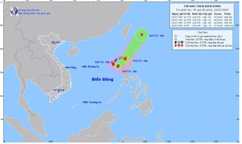 |
| Map of forecasted storm trajectory and intensity in the East Sea released at 5:00 a.m. on July 24. (Photo: National Center for Hydro-Meteorological Forecasting). |
Weather forecast for provinces and cities on July 24 as follows:
Northwest: Cloudy, moderate rain, heavy rain and thunderstorms during the day, locally very heavy rain; light wind; thunderstorms with possibility of tornadoes, lightning and strong gusts of wind; temperature 22-30 degrees Celsius.
Northeast: Cloudy, moderate rain, heavy rain and thunderstorms during the day, locally very heavy rain; Southeast to East wind level 2-3; in thunderstorms there is a possibility of tornadoes, lightning and strong gusts of wind; temperature 23-31 degrees Celsius.
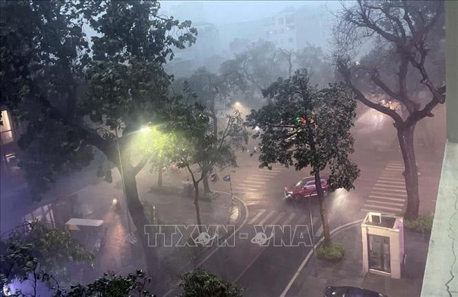 |
Today's weather (July 24): Many areas across the country have thunderstorms. Illustration photo: VNA |
Hanoi area: Occasionally there will be showers and thunderstorms, locally heavy rain; Southeast to East wind level 2-3; in thunderstorms there is a possibility of tornadoes, lightning and strong gusts of wind; temperature 24-31 degrees Celsius.
Provinces from Thanh Hoa to Hue: Cloudy, showers and thunderstorms in some places, especially Thanh Hoa - Nghe An , moderate rain, heavy rain and thunderstorms, locally very heavy rain in some places; South to Southwest wind level 2-3; in thunderstorms there is a possibility of tornadoes, lightning and strong gusts of wind; temperature 24-33 degrees Celsius.
South Central Coast: Cloudy, scattered showers and thunderstorms in the evening, sunny during the day, hot in some places; Southwest wind level 2-3; thunderstorms with possibility of tornadoes, lightning, hail and strong gusts of wind; temperature 26-35 degrees Celsius.
Central Highlands: Cloudy, scattered showers and thunderstorms, scattered showers and thunderstorms in the afternoon, locally heavy rain in some places; Southwest wind level 2-3; possibility of tornadoes, lightning and strong gusts in thunderstorms; temperature 20-30 degrees Celsius.
Southern region: Cloudy, scattered showers and thunderstorms, scattered showers and thunderstorms in the afternoon, locally heavy rain in some places; Southwest wind level 2-3; possibility of tornadoes, lightning and strong gusts of wind in thunderstorms; temperature 24-34 degrees Celsius.
Ho Chi Minh City: There will be showers and thunderstorms in some places; in the afternoon and evening there will be scattered showers and thunderstorms, locally heavy rain in some places; Southwest wind level 2-3; in thunderstorms there is a possibility of tornadoes, lightning and strong gusts of wind; temperature 24-34 degrees Celsius.
Hoang Sa Special Zone (Da Nang): Scattered showers and thunderstorms; tornadoes and strong gusts of wind are possible during thunderstorms; visibility is over 10km; West wind level 4-5; waves 2-3m high.
Truong Sa special economic zone (Khanh Hoa): No rain; visibility over 10km; Southwest wind level 5; waves 2-3m high.
THANH HAI
* Please visit the Society section to see related news and articles.
Source: https://baolamdong.vn/thoi-tiet-hom-nay-24-7-bao-so-4-comay-giat-cap-11-o-phia-dong-khu-vuc-bac-bien-dong-383456.html


Comment (0)