
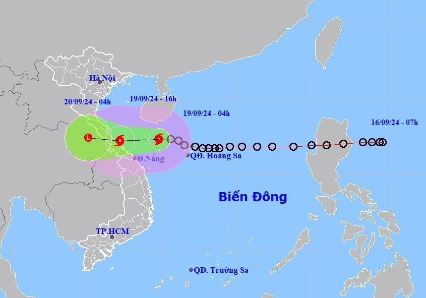
According to the National Center for Hydro-Meteorological Forecasting, early this morning (September 19), the tropical depression in the northeastern area of Hoang Sa archipelago strengthened into storm No. 04 of 2024. At Con Co (Quang Tri), there were strong winds of level 6, gusting to level 7.
At 4:00 a.m. on September 19, the center of storm No. 4 was at about 17.3 degrees North latitude; 109.8 degrees East longitude, about 217km northeast of Da Nang and about 260km east of Quang Tri.
Storm No. 4 has the strongest wind speed of level 8 (62-74km/h), gusting to level 10. It is forecasted that in the next hours, the storm will move westward at a speed of about 20km/h.
Forecast of storm No. 4 in the next 24 hours:
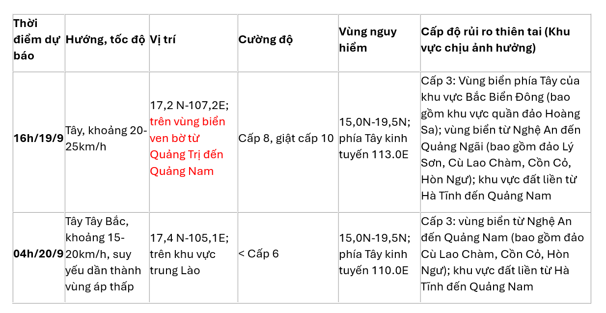
Storm No. 4 is forecast to cause strong winds, big waves, and rising water.
At sea , the western sea area of the North East Sea (including the Hoang Sa archipelago), the sea area from Nghe An to Quang Ngai (including Ly Son island district, Cu Lao Cham, Con Co, Hon Ngu) has strong winds of level 6-7 (39-61km/h), waves 2-4m high, the area near the storm center has level 8 (62-74km/h), gusts of level 10 (89-102km/h), waves 3-5m high, rough seas.
In addition, due to the influence of the strong southwest monsoon, in the sea area from Binh Dinh to Ca Mau; the south of the central East Sea area, the south East Sea area (including the sea area of Truong Sa archipelago), the southwest wind is strong at level 6, sometimes level 7, gusting to level 8-9, waves are 3-5m high. The sea is rough.
Coastal provinces from Quang Binh to Quang Nam need to be on guard against storm surges of 0.3-0.5m high, combined with high tides and big waves causing landslides of sea dykes and embankments, and flooding in low-lying areas.
Ships operating in the above mentioned dangerous areas are susceptible to the effects of storms, whirlwinds, strong winds and large waves.
On land , from the morning of September 19, coastal areas from Ha Tinh to Quang Nam will have winds gradually increasing to level 6-7, near the storm's eye level 8 (62-74km/h), gusting to level 10 (89-102km/h); deep inland, winds will gust to level 6-7.
Beware of strong thunderstorms ahead of the storm. In the event of strong thunderstorms, the consequences may include trees falling, roofs, and billboards being blown into the air.
Storm No. 4 causes heavy rain: From September 19 to September 20, in the North Central and Central Central regions, there will be heavy to very heavy rain with common rainfall from 100-300mm, locally over 500mm. Beware of heavy rain (>150mm/6 hours) in the area from Quang Tri - Da Nang on September 19.
On September 19, the Central Highlands and the South will have moderate rain, heavy rain and thunderstorms, locally very heavy rain with common rainfall from 20-40mm, some places over 70mm.
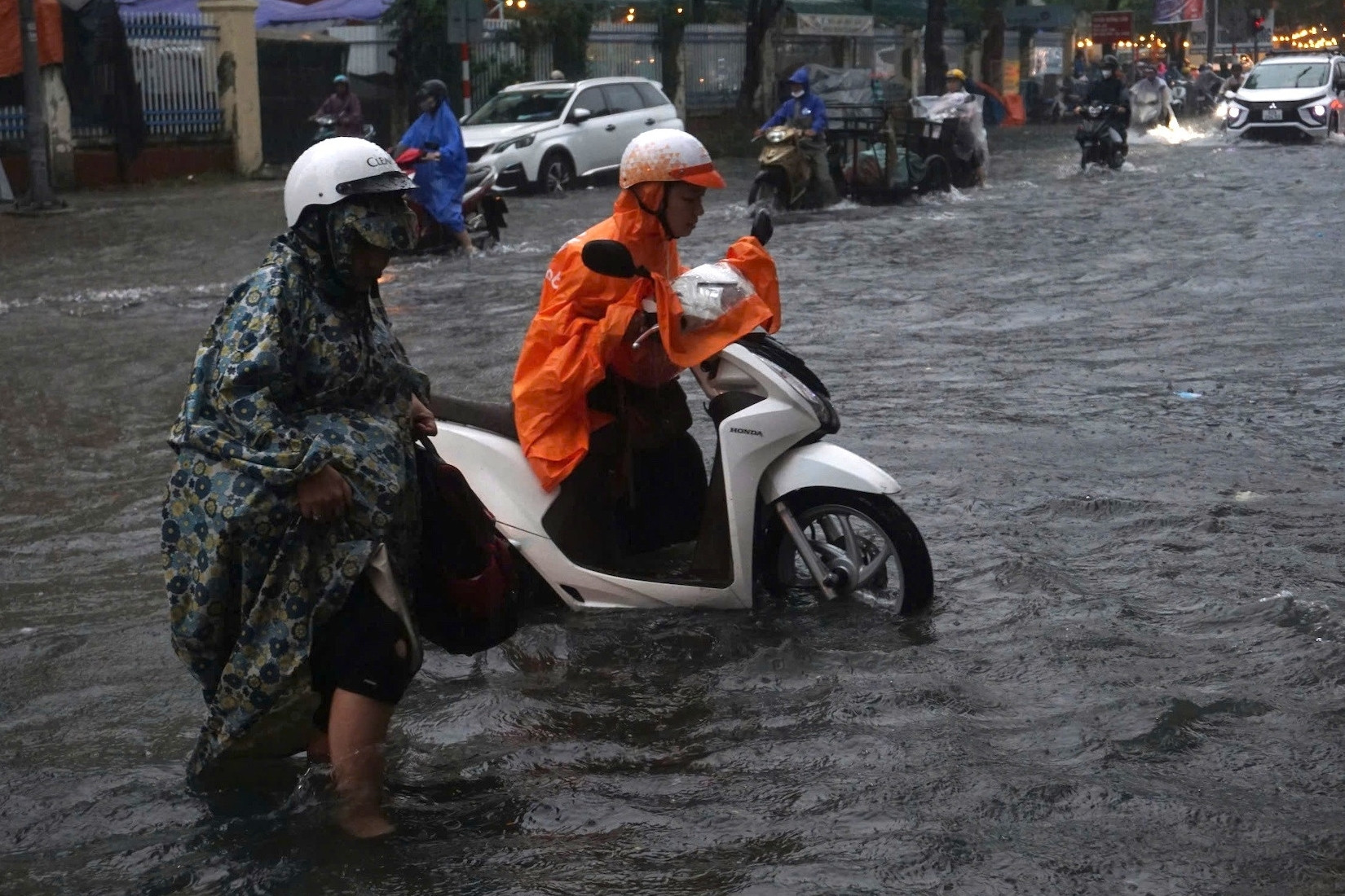
Heavy rains lead to flooding in densely populated urban areas because the water cannot drain quickly.
Source: https://vietnamnet.vn/tin-bao-so-4-khan-cap-gio-giat-cap-10-cach-da-nang-hon-200km-2323640.html


Comment (0)