
According to the National Center for Meteorological and Hydrological Forecasting, as of today (October 3rd), there are localized showers and thunderstorms in the southwestern region of Vietnam.
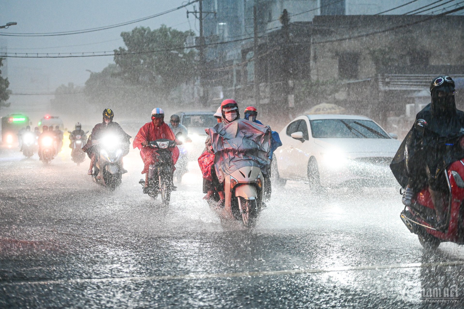
The forecast for today indicates scattered showers and thunderstorms in the southern Central Highlands and Southern Vietnam, with some areas experiencing heavy rain, with rainfall amounts ranging from 10-30mm, and some areas exceeding 70mm.
During thunderstorms, there is a possibility of tornadoes, lightning, hail, and strong gusts of wind. Localized heavy rainfall may cause flooding in low-lying areas; flash floods on small rivers and streams, and landslides on slopes.
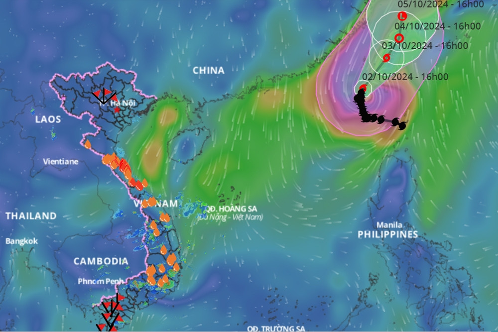
The Southern Vietnam Regional Hydrometeorological Station also stated that the Southern region and Ho Chi Minh City are mainly affected by the southern edge of a strengthening cold high-pressure ridge moving southward. Weak northeasterly winds dominate the weather in the area, with the possibility of disturbances in the low-level easterly wind zone moving into the region. From October 6th, a low-pressure trough will form at approximately 5-7 degrees North latitude, gradually shifting its axis northward, strongly influencing the weather in the area.
Due to the conflict between weather patterns, wind disturbances occur, resulting in mostly cloudy skies with scattered to widespread rain and showers throughout the week, with generally light to moderate rainfall; some days may experience heavy rain in the early morning or late evening.
Specifically, from October 3-5, the weather will be cloudy with widespread rain, possibly in the early morning due to the influence of a low-level easterly wind disturbance; the northeast wind will be weak to moderate. Temperatures will decrease slightly, with a high of 30-33 degrees Celsius and a low of 23-25 degrees Celsius.
Additionally, from October 6-10, the low-pressure trough will gradually become more active and affect the weather in the area, resulting in cloudy weather with scattered showers and thunderstorms. The highest temperature will be 29-33 degrees Celsius; the lowest will be 22-25 degrees Celsius.
Currently, the Southern Vietnam Regional Hydrometeorological Station reports that (at 10:30 AM), the continental cold high pressure system is stable and gradually weakening. The low-pressure trough with its axis over Central Vietnam is being compressed, weakened, and gradually filling up. At higher altitudes, the southern branch of the subtropical high pressure system is weakening. Upper-level disturbances are more active and influencing Southern Vietnam.
Monitoring of satellite cloud imagery, weather radar images, and lightning location data shows that thunderstorms are developing and bringing rain, thunderstorms, and lightning to the areas of Can Gio, Binh Chanh, Districts 4, 5, 6, 8, and Thu Duc City.
Over the next 0-3 hours (starting from 10:30 AM on October 3rd), thunderstorms will continue to develop, causing showers, accompanied by...
Thunderstorms and lightning are expected in the aforementioned districts and counties, then spreading to other neighboring areas. Rainfall will generally range from 5-15mm, with some areas receiving over 15mm. During thunderstorms, be wary of tornadoes, hailstorms, and strong gusts of wind (approximately level 5-7, 8-17 m/s), with heavy rain causing localized flooding.
Furthermore, Ho Chi Minh City is preparing for the high tide period at the beginning of September in the lunar calendar. The peak tide coincides with the forecast of heavy rain in the coming days. The combination of rain and high tide could cause more severe flooding in areas along rivers and canals due to slow drainage.
Warning of localized heavy rain in Southern Vietnam. According to the Southern Vietnam Regional Hydrometeorological Station, this morning (October 3rd), a combination of satellite cloud imagery, lightning location data, and weather radar images shows that convective clouds continue to develop over the provinces of Kien Giang, An Giang , Dong Thap, Vinh Long, Tay Ninh, Binh Duong (Ben Cat, Tan Uyen), Dong Nai (Trang Bom, Thong Nhat, Long Thanh), Ba Ria - Vung Tau (Vung Tau City), Ho Chi Minh City (Can Gio, District 9, Binh Chanh, Nha Be), Tien Giang, Ben Tre, Vinh Long (Vung Liem, Binh Tan), Tra Vinh, Soc Trang, and Can Tho. The cloud clusters are showing little movement but will continue to expand. From now (10:00 AM on October 3rd) until the next 4 hours, this convective cloud system will cause showers and thunderstorms in the aforementioned area and surrounding regions. Some places may experience rainfall of approximately 30mm/2h. During thunderstorms, there is a possibility of tornadoes, lightning, hail, and strong gusts of wind. |

With the emergence of La Nina, Ho Chi Minh City could experience temperatures below 20 degrees Celsius towards the end of the year.

Hanoi weather forecast for the next 3 days: Sunny and dry, cool nights with a temperature difference of more than 10 degrees.
Source: https://vietnamnet.vn/tphcm-mua-nhieu-ngay-toi-ca-sang-som-va-chieu-toi-2328356.html

![[Photo] Delegation attending the 14th Congress of the Vietnam Trade Union visits the Mausoleum of President Ho Chi Minh.](https://vphoto.vietnam.vn/thumb/1200x675/vietnam/resource/IMAGE/2026/06/03/1780451842301_ndo_br_img-3824-jpg.webp)


Comment (0)