
On October 6 alone, as of noon, the Earthquake Information and Tsunami Warning Center - Institute of Earth Sciences , Vietnam Academy of Science and Technology has just issued 9 consecutive earthquake notices in Mang But and Mang Ri communes (Quang Ngai province), including an earthquake with a magnitude of 4.9 on the Richter scale. Natural disaster risk level 1.
Accordingly, at 00:41 on October 6, an earthquake of magnitude 2.6 occurred at the coordinates (14.871 degrees North latitude, 108.141 degrees East longitude), with a focal depth of about 8.1 km. The earthquake occurred in Mang But commune ( Quang Ngai province). Natural disaster risk level 0.
At 1am the same day, another earthquake with a magnitude of 2.6 occurred at the coordinates (14.875 degrees North latitude, 108.146 degrees East longitude), with a focal depth of about 8.1 km. The earthquake occurred in Mang But commune. The natural disaster risk level is level 0.
Next, at 1:28 a.m. on the same day, another earthquake with a magnitude of 4.9 occurred at the coordinates (14.871 degrees North latitude, 108.130 degrees East longitude), with a focal depth of about 8.1 km. The earthquake occurred in Mang Ri commune (Quang Ngai province). Natural disaster risk level 1.
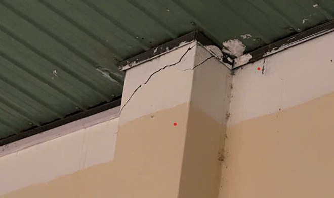
Mang But Primary and Secondary School (campus 2), Quang Ngai province had cracked walls and damaged tiled roofs due to the earthquake. Photo: Thanh Tuan
At 1:46 a.m. on the same day, another earthquake with a magnitude of 2.9 occurred at the coordinates (14.830 degrees North latitude, 108.132 degrees East longitude), with a focal depth of about 8.1 km. The earthquake occurred in Mang Ri commune. The natural disaster risk level is 0... Up to this point, 9 earthquakes have occurred in Mang But and Mang Ri communes.
In particular, the 4.9 magnitude earthquake caused many people in Gia Lai, Quang Ngai, Da Nang City, etc. to feel strong tremors.
Previously, Mang But commune also had consecutive earthquakes. From the evening of October 5 to 5:57 a.m. on October 6, there were 19 consecutive earthquakes in Mang But and Mang Ri communes. The Earthquake Information and Tsunami Warning Center - Institute of Earth Sciences is still monitoring this earthquake.
According to statistics, from 2021 to now, the Kon Plong area (former Kon Tum province) has recorded more than 1,000 earthquakes from 3.0 to 5.0 magnitude, including those that caused widespread tremors. The largest was the one at noon on July 28, 2024 with a magnitude of 5.0; before that on August 23, 2022, there was an earthquake with a magnitude of 4.7.
Explaining the cause of the consecutive earthquakes, Dr. Nguyen Xuan Anh, Director of the Earthquake Information and Tsunami Warning Center (Institute of Earth Sciences), said that these are stimulated earthquakes, usually of weak or medium intensity, and rarely cause serious damage like natural tectonic earthquakes.
Mr. Xuan Anh analyzed that induced earthquakes are a type of earthquake that occurs due to human activities, not due to natural tectonic processes. The most common cause of induced earthquakes is the process of water storage in large hydroelectric reservoirs. When a huge amount of water is stored in the reservoir of a hydroelectric dam, this volume of water creates a huge pressure on the underlying soil and rock layers. Water can seep into the fault zones in the ground, changing the stress state, increasing pore pressure and reducing the shear strength of the rock. This can activate existing but "dormant" geological faults, causing earthquakes.
In addition, large-scale mining can also change the geological structure, causing subsidence and triggering earthquakes due to the process of injecting liquid into the ground. Large underground explosions for underground nuclear testing are also the cause of stimulated earthquakes.
Scientists say that induced earthquakes are usually of weak or medium intensity and rarely cause serious damage like natural tectonic earthquakes. In Vietnam, induced earthquakes are often recorded in areas with large hydroelectric reservoirs such as Song Tranh 2 (formerly Quang Nam) or Kon Plong (formerly Kon Tum).
Mr. Anh explained that the two localities of Da Nang (formerly Quang Nam area) and Quang Ngai (formerly Kon Tum area) often experience earthquakes mainly due to a combination of natural geological factors and earthquakes stimulated by human activities. Specifically, these two areas are located on active or potentially active geological faults. However, the most important factor causing the recent high frequency of earthquakes is the operation of large hydroelectric reservoirs.
In the Song Tranh 2 Hydropower Plant area, the huge volume of water in the reservoir has created pressure on the faults, changing the stress and triggering earthquakes. Similarly, in the old Kon Tum area, hydropower reservoirs such as Thuong Kon Tum have also been identified as the cause of hundreds of small and medium earthquakes. These earthquakes, although usually not too large in magnitude (under 5.5), occur continuously, causing tremors and somewhat affecting people's lives. It is forecasted that stimulated seismic activity in these areas can last for many years.
Data from the Institute of Earth Sciences shows that from April 2021 to now, hundreds of earthquakes have occurred in these areas, many of which caused felt tremors. The strongest earthquake in Kon Plong occurred at noon on July 28, 2024 with a magnitude of 5.0. This is considered the strongest earthquake ever in this area, causing tremors felt in many neighboring provinces and cities such as Da Nang and Ho Chi Minh City.
Source: https://cand.com.vn/doi-song/xay-ra-19-tran-dong-dat-o-quang-ngai-trong-2-ngay--i783718/

![[Photo] Prime Minister Pham Minh Chinh chairs a meeting of the Government Standing Committee to remove obstacles for projects.](https://vphoto.vietnam.vn/thumb/1200x675/vietnam/resource/IMAGE/2025/10/06/1759768638313_dsc-9023-jpg.webp)


Comment (0)