

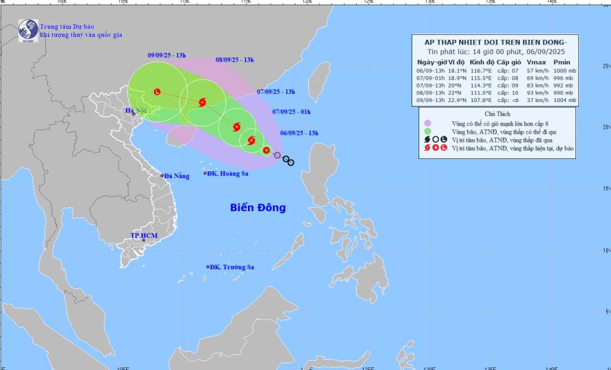
Forecast map of tropical depression trajectory and intensity at 14:00 on September 6, 2025.
At 01:00 on September 7, the tropical depression moved northwest at a speed of 10-15 km/h, with the potential to strengthen into a storm. The location is at 18.9 degrees north latitude - 115.5 degrees east longitude, about 430 km northeast of Hoang Sa archipelago. Strong winds level 8, gusts level 10. Disaster risk level: level 3, northeastern sea area of the East Sea.
At 1 p.m. on September 7, the storm continued to move northwest at a speed of 10–15 km/h and strengthened. Location at 20 degrees North latitude – 114.3 degrees East longitude, about 420 km northeast of Hoang Sa archipelago. Strong winds level 9, gusts level 12. Disaster risk level: level 3, northern waters of the East Sea.
Forecast, by 13:00 on September 8, the storm continues to move northwest, speed of about 15 km/h and strengthens. Location at 22 degrees North latitude - 111.5 degrees East longitude, on the mainland of Guangdong province (China). Strong wind level 10, gust level 13. Disaster risk level: level 3, northwest sea area of the East Sea.
During the next 48–72 hours, the storm will move in a West Northwest direction at a speed of about 15 km/h and will tend to weaken gradually.
The northeastern sea area of the East Sea has strong winds of level 6, later increasing to level 7; the area near the storm center has strong winds of level 8-9, gusting to level 12; waves 3-5 m high, very rough seas. Ships operating in the danger zone are likely to be affected by storms, whirlwinds, strong winds and big waves.
LP
Source: https://baothanhhoa.vn/ap-thap-nhiet-doi-di-chuyen-theo-huong-tay-bac-toc-do-15km-h-260759.htm
![[Photo] Impressive display booths of provinces and cities at the Exhibition 80 years of the Journey of Independence - Freedom - Happiness](https://vphoto.vietnam.vn/thumb/1200x675/vietnam/resource/IMAGE/2025/9/7/cd63e24d8ef7414dbf2194ab1af337ed)


![[Highlight] VIMC's mark at the National Achievement Exhibition](https://vphoto.vietnam.vn/thumb/402x226/vietnam/resource/IMAGE/2025/9/7/932133a54d8b4becad48ef4f082f3eea)


Comment (0)