
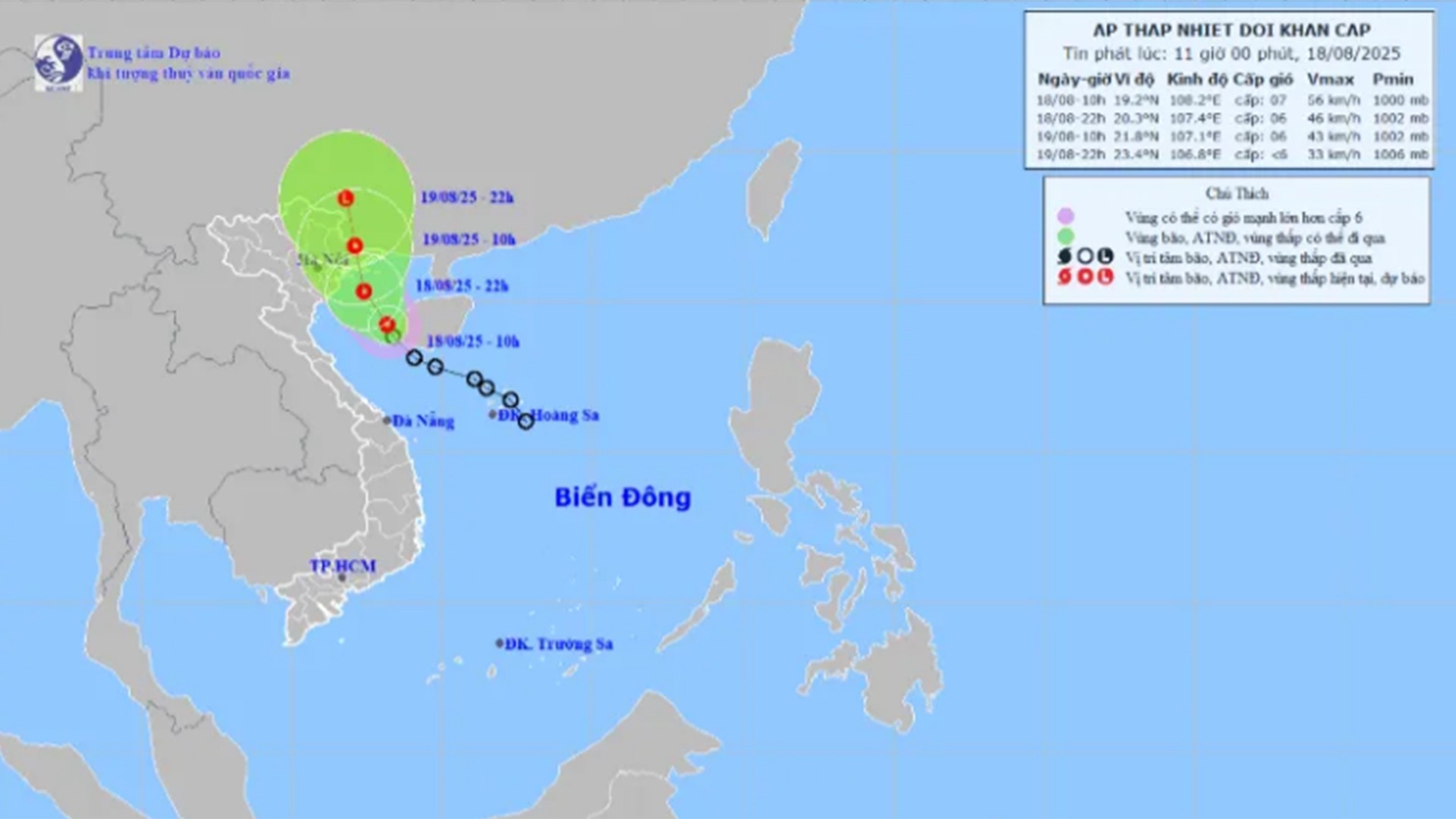
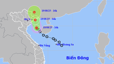
According to the National Center for Hydro-Meteorological Forecasting, at 10:00 a.m. on August 18, the center of the tropical depression was located at about 19.2 degrees North latitude; 108.2 degrees East longitude, about 115km South-Southeast of Bach Long Vi special zone. The strongest wind near the center of the tropical depression was level 6-7 (39-61km/h), gusting to level 9 ; moving in a North-Northwest direction at a speed of about 15km/h.
At 10:00 a.m. on August 19, the tropical depression moved in the Northwest direction at 10-15 km/h, located at 21.8°N - 107.1°E (on the Vietnam - China border), wind level 6, gust level 8.
Danger zone: North of latitude 18.5°N; West of longitude 109.0°E.
Disaster risk level: level 3 in the Gulf of Tonkin (including Bach Long Vi, Cat Hai, Co To and Van Don special zones).
At 10:00 p.m. on August 19: The tropical depression moved northwest at 10-15 km/h, weakening into a low pressure area at 23.4°N – 106.8°E (over Guangxi (China)).
Forecast impact of tropical depression:
Strong winds, big waves:
– At sea: Bac Bo Gulf (including Bach Long Vi, Cat Hai, Co To, Van Don) has strong winds of level 6-7, gusting to level 9; waves 2.0-3.5m high, rough seas.
– Vessels in dangerous areas are susceptible to storms, tornadoes, strong winds and large waves.
– On land: from the afternoon of August 18, the coast of Quang Ninh – Hai Phong has strong winds of level 6, gusting to level 8.
Heavy rain:
– From August 18 to the night of August 19: Northeast and Thanh Hoa have moderate rain, heavy rain and thunderstorms, locally very heavy rain: 50-150mm, some places >300mm.
– Day and night of August 18: Nghe An and Ha Tinh have moderate rain, heavy rain and thunderstorms, locally very heavy rain: 30-60mm, some places >150mm.
Source: https://baolaocai.vn/ap-thap-nhiet-doi-giat-cap-9-gay-mua-lon-o-bac-bo-va-bac-trung-bo-post879897.html


![[Photo] Prime Minister Pham Minh Chinh attends the opening ceremony of the National Data Center](https://vphoto.vietnam.vn/thumb/1200x675/vietnam/resource/IMAGE/2025/8/18/b5724a9c982b429790fdbd2438a0db44)


Comment (0)