

The western sea area of the North East Sea (including the Hoang Sa special zone) has thunderstorms and strong winds of level 6-7, gusts of level 8-9, waves 2.0-3.5m high, rough seas.
Accordingly, Vietnam Maritime Electronic Information Company Limited is required to direct the coastal information station system to closely monitor, continuously update the developments, location, and direction of the tropical depression and promptly notify vehicles and captains operating at sea to proactively avoid entering dangerous areas.
Count and strictly manage ships going out to sea
The Vietnam Maritime Administration is responsible for directing port authorities to closely monitor the situation, guide ships when granting permission to leave port, count and strictly manage departures; Maintain regular contact with transport ships and tourist boats in the affected area to promptly handle emergency situations.
Anchoring work at the wharf, especially in the area around the island, must also be strictly inspected and guided.
Vietnam Maritime Search and Rescue Coordination Center prepares full force and equipment, ready to participate in rescue when requested.
The Ministry of Construction emphasized: Units must organize 24/7 duty, regularly report to the Ministry of Construction's Command Committee for Natural Disaster Prevention and Search and Rescue for timely direction.
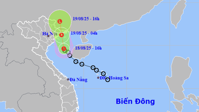
According to the bulletin of the National Center for Hydro-Meteorological Forecasting, at 7:00 a.m. on August 17, the center of the tropical depression was located at about 17.1 degrees North latitude; 111.5 degrees East longitude, in the sea northwest of Hoang Sa special zone. The strongest wind near the center of the tropical depression was level 6 (39-49 km/h), gusting to level 8; moving northwest at a speed of 10-15 km/h.
Forecast of the impact of the tropical depression at sea: The western sea area of the North East Sea (including the Hoang Sa special zone) will have thunderstorms and strong winds of level 6-7, gusts of level 8-9, waves 2.0-3.5m high, rough seas.
From early morning on August 18, the Gulf of Tonkin has seen winds gradually increasing to level 6, gusting to level 8, waves 2-3m high, and rough seas. Ships operating in the above-mentioned dangerous areas are likely to be affected by storms, whirlwinds, strong winds, and large waves.
PT
Source: https://baochinhphu.vn/ap-thap-nhiet-doi-tren-bien-dong-quan-ly-chat-tau-thuyen-ra-khoi-102250818002531816.htm


![[Photo] Prime Minister Pham Minh Chinh attends the opening ceremony of the National Data Center](https://vphoto.vietnam.vn/thumb/1200x675/vietnam/resource/IMAGE/2025/8/18/b5724a9c982b429790fdbd2438a0db44)


Comment (0)