
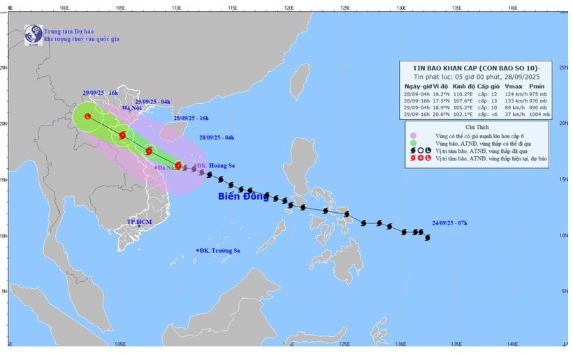
Commenting on the developments of storm No. 10, Dr. Hoang Phuc Lam, Deputy Director of the National Center for Hydro-Meteorological Forecasting, said that storm No. 10 is likely to strengthen towards the sea area of Nghe An - Quang Tri.
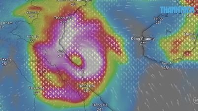
According to the National Center for Hydro-Meteorological Forecasting, at 4:00 a.m. on September 28, the eye of the storm was located at about 16.2 degrees North latitude; 110.2 degrees East longitude, in the sea west of Hoang Sa special zone, about 200km east of Da Nang city. The strongest wind near the eye of the storm was level 12 (118-133km/h), gusting to level 15. Moving in the West Northwest direction at a speed of 30km/h.
This is a very fast moving storm (nearly twice the average speed), with strong storm intensity and wide range of influence, which can cause combined impacts of many types of natural disasters such as strong winds, heavy rains, floods, flash floods, landslides and coastal flooding.
By 4 p.m. on September 28, the storm was in the sea area of Nghe An-Quang Tri with strong winds of 12-13, gusting to level 16; moving in the West Northwest direction at about 30 km/h and likely to strengthen. The affected area is the sea area in the Northwest and the middle of the East Sea (including Hoang Sa special zone), the sea area from Thanh Hoa to Quang Ngai . Natural disaster risk level 3.
By 4:00 a.m. on September 29, the storm was on the mainland of the provinces from Thanh Hoa to Ha Tinh with winds of level 9-10, gusts of level 13; moving in the West Northwest direction at a speed of about 25-30 km/h and entering the mainland of the Central region. The affected areas are the coastal mainland areas from Nghe An to Quang Tri with a level 4 natural disaster risk level; the western sea area of the North and the middle of the East Sea (including Hoang Sa special zone), from Thanh Hoa to Quang Ngai. Risk level level 3.
At 4:00 p.m. on September 29, the storm in the Upper Laos region with winds below level 6; moving in the West Northwest direction at about 20-25 km/h, moving deep inland and weakening into a tropical depression and then a low pressure area.
The affected areas are from Thanh Hoa to Quang Tri (including Hon Ngu Island) and the northern Gulf of Tonkin (including Bach Long Vy Special Zone, Van Don, Co To, Cat Hai and Hon Dau Island); the mainland area from Ninh Binh to Quang Tri. Disaster risk level 3.
Due to the influence of the storm, the western sea area of the North and Central East Sea (including Hoang Sa special zone) has strong winds of level 8-9, the area near the eye of the storm has level 10-13, gusts of level 16, waves 6-8m high, the area near the eye of the storm is 8-10m, the sea is very rough. The sea area from Thanh Hoa to Quang Ngai (including Hon Ngu island, Con Co special zone and Ly Son) has strong winds of level 6-7, then increases to level 8-9, the area near the eye of the storm has level 10-13, gusts of level 16, waves 5-7m high, the sea is very rough (extremely destructive, extremely strong waves. Sinking large tonnage ships).
In the Northern Gulf of Tonkin (including Bach Long Vi, Van Don, Co To, Cat Hai and Hon Dau islands), the wind gradually increases to level 6-7, then increases to level 8-9 (very rough seas, very dangerous for boats), gusts to level 11, waves 3-5m high, very rough seas.
Coastal areas and islands from Ninh Binh to Ha Tinh have storm surges of 0.5-1.5m, especially from South Thanh Hoa to North Ha Tinh where they are 1.0-1.5m high. The risk of flooding of dykes, coastal roads, and river mouths due to storm surges and waves is very high on the evening and night of September 28.
Warning: The weather at sea and in coastal areas during the storm is extremely dangerous and unsafe for any vehicle or structure operating in the danger zone such as: cruise ships, passenger ships, transport ships, cages, rafts, aquaculture areas, dykes, embankments, coastal routes. Vehicles are at high risk of capsize, destruction, and flooding due to strong winds, big waves, and rising sea levels.
On land: From South Quang Tri to Da Nang, wind gradually increases to level 6-7 (trees shake, difficult to go against the wind), gusts of level 8-9.
From noon on September 28, on the mainland from Thanh Hoa to Northern Quang Tri, the wind gradually increased to level 6-7, then increased to level 8-9, near the storm center level 10-12 (wind force can knock down trees, houses, electric poles, causing very heavy damage), gusting to level 14. From afternoon on September 28, coastal areas from Quang Ninh to Ninh Binh had strong winds of level 6-7, gusting to level 8-9.
From September 28 to September 30, in the North and the area from Thanh Hoa to Quang Ngai, there is a possibility of widespread heavy rain with total rainfall from 100-300mm, locally over 450mm; in the Northern Delta, South Phu Tho and from Thanh Hoa to North Quang Tri, it is common from 200-400mm, locally over 600mm. Warning of the risk of heavy rain over 200mm/3 hours. In the area from South Quang Tri to Quang Ngai, there are places with rain over 400mm.
The National Center for Hydro-Meteorological Forecasting said that from the morning of September 28 to September 29, in the area from Thanh Hoa to the North of Quang Tri, there will be heavy to very heavy rain with common rainfall of 200-400mm, locally over 600mm; in the area from South Quang Tri to Quang Ngai, there will be heavy rain, locally very heavy rain with common rainfall of 100-300mm, locally over 400mm. Warning of the risk of heavy rain over 100mm/h.
From the afternoon of September 28 to the night of September 29, the Northern Delta and Southern Phu Tho will have heavy to very heavy rain with common rainfall of 150-300mm, locally over 500mm; other areas in the North will have moderate to heavy rain with common rainfall of 100-200mm, locally over 350mm. Warning of the risk of heavy rain (>100mm/3 hours).
In addition, on the day and night of September 28, the area from Gia Lai to Lam Dong and the South will have scattered showers and thunderstorms with rainfall of 20-40mm, locally heavy rain over 100mm. Warning of risk of heavy rain over 100mm/3h).
On September 30, the Northern region, Thanh Hoa and Nghe An will have moderate rain, heavy rain, and locally very heavy rain with common rainfall of 20-50mm, locally over 100mm.
Total rainfall from the night of September 27 to September 30 in the Northern Delta, Southern Phu Tho and from Thanh Hoa to Northern Quang Tri is generally from 200-400mm, locally over 600mm; other places in the North and the area from Southern Quang Tri to Quang Ngai are generally from 100-300mm, locally over 450mm.
Natural disaster risk level due to heavy rain, tornadoes, lightning, hail is level 1, and level 2 in the area from Thanh Hoa to Northern Quang Tri.
"Heavy rain is likely to cause flooding in low-lying areas, urban and industrial areas; flash floods on small rivers and streams, landslides on steep slopes (real-time warning information on areas at risk of flash floods and landslides is provided online on the website of the Department of Hydrometeorology at: https://luquetsatlo.nchmf.gov.vn and in a separate bulletin warning of flash floods and landslides). During thunderstorms, there is a possibility of tornadoes, lightning, hail and strong gusts of wind," noted Head of the Weather Forecast Department Nguyen Van Huong.
On the night of September 27 and early morning of September 28, the area from Thanh Hoa to Quang Ngai had moderate rain, heavy rain, and in some places very heavy rain and thunderstorms. The rainfall from 7:00 p.m. on September 27 to 3:00 a.m. on September 28 was over 90mm in some places such as: Huong Trach 1 station (Ha Tinh) 94mm, Tan Hoa station (Quang Tri) 102.4mm, Hong Trung station (Hue city) 93.8mm.
Weather in regions day and night September 28:
In the Northwest, it is cloudy during the day with scattered showers and thunderstorms; at night there is moderate rain, heavy rain and thunderstorms, locally very heavy rain, with the possibility of tornadoes, lightning and strong gusts of wind during thunderstorms. The lowest temperature is 22-25 degrees Celsius, in some places below 21 degrees Celsius. The highest temperature is 29-32 degrees Celsius, in some places above 32 degrees Celsius.
In the Northeast, in the afternoon and at night, there will be moderate rain, heavy rain and scattered thunderstorms, locally very heavy rain; in the plains, there will be heavy to very heavy rain at night. Northeast wind level 3; in the coastal areas of Quang Ninh to Ninh Binh, from the afternoon, the wind will gradually increase to level 6-7, gusting to level 8-9. In thunderstorms, there is a possibility of tornadoes, lightning and strong gusts of wind.
Lowest temperature 22-25 degrees Celsius, in mountainous areas below 21 degrees Celsius. Highest temperature 28-31 degrees Celsius, in some places above 31 degrees Celsius.
In Hanoi, in the afternoon and at night there will be moderate rain, heavy rain and thunderstorms, locally very heavy rain, with the possibility of tornadoes, lightning and strong gusts of wind. Northeast wind level 3. Lowest temperature 23-25 degrees Celsius. Highest temperature 30-32 degrees Celsius.
Provinces and cities from Thanh Hoa to Hue will have heavy to very heavy rain and thunderstorms, with the possibility of tornadoes, lightning and strong gusts of wind. Northwest wind level 3-4. From the afternoon, the area from Thanh Hoa to Northern Quang Tri will gradually increase to level 6-7, then increase to level 8-9, near the storm center will increase to level 10-12, gusting to level 14, from Southern Quang Tri to Hue city will gradually increase to level 6-7, gusting to level 8-9. Lowest temperature 22-25 degrees Celsius. Highest temperature 26-29 degrees Celsius.
South Central Coast, the North has heavy rain and thunderstorms, locally very heavy rain; the South has scattered showers and thunderstorms, locally heavy rain, with the possibility of tornadoes, lightning, hail and strong gusts of wind. West to Southwest wind level 3-4, in the North during the day some places level 5, gusting to level 6-7. Lowest temperature 23-26 degrees Celsius. Highest temperature 28-31 degrees Celsius, in the South some places above 31 degrees Celsius.
The Central Highlands has scattered showers and thunderstorms, with some places experiencing heavy rain. Thunderstorms are likely to produce tornadoes, lightning, hail, and strong gusts of wind. Southwest wind level 2-3. Lowest temperature 19-22 degrees Celsius. Highest temperature 25-28 degrees Celsius.
The Southern region has scattered showers and thunderstorms, locally heavy rain, with the possibility of tornadoes, lightning, hail and strong gusts of wind. Southwest wind level 2-3. Lowest temperature 23-26 degrees Celsius. Highest temperature 29-32 degrees Celsius.
Ho Chi Minh City has scattered showers and thunderstorms, locally heavy rain, with the possibility of tornadoes, lightning, hail and strong gusts of wind. Southwest wind level 2-3. Lowest temperature 24-26 degrees Celsius. Highest temperature 29-32 degrees Celsius.
Source: https://baodanang.vn/bao-bualoi-co-kha-nang-manh-them-huong-ve-khu-vuc-vung-bien-nghe-an-quang-tri-3304853.html
![[Photo] High-ranking delegation of the Russian State Duma visits President Ho Chi Minh's Mausoleum](https://vphoto.vietnam.vn/thumb/1200x675/vietnam/resource/IMAGE/2025/9/28/c6dfd505d79b460a93752e48882e8f7e)
![[Photo] Joy on the new Phong Chau bridge](https://vphoto.vietnam.vn/thumb/1200x675/vietnam/resource/IMAGE/2025/9/28/b00322b29c8043fbb8b6844fdd6c78ea)


![[Photo] The 4th meeting of the Inter-Parliamentary Cooperation Committee between the National Assembly of Vietnam and the State Duma of Russia](https://vphoto.vietnam.vn/thumb/1200x675/vietnam/resource/IMAGE/2025/9/28/9f9e84a38675449aa9c08b391e153183)


Comment (0)