
According to the European Centre for Medium-Range Weather Forecasts (ECMWF), there is a high probability of a tropical depression or storm entering the South China Sea in the coming days. This is a complex weather development that requires special attention for timely prevention and response.

The Global Forecast System (GFS) of the U.S. National Oceanic and Atmospheric Administration (NOAA) also shares the same warning model as the ECMWF.

According to meteorological experts, the low-pressure area is currently strengthening into a tropical depression (approaching the east of the Philippines) and may develop into a typhoon. Within the next two days, this typhoon is likely to move into the northern South China Sea.
The storm's trajectory also depends on the intensity of the continental high-pressure system over China. If the high-pressure system is strong, the storm may head towards the Gulf of Tonkin. If the high-pressure system is weak, the storm may deviate towards China.
Meteorological experts believe that, in addition to the low-pressure area in the Philippines, a low-pressure vortex in the Spratly Islands area is showing signs of combining with the low-pressure area in the Philippines, potentially drawing the tropical depression further into the South China Sea.
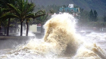
Due to the influence of complex weather patterns, the South, Central Highlands, and the southern part of the East Sea are forecast to experience bad weather, with the possibility of strong winds and heavy rain. The central East Sea near the Philippines and the northern East Sea are also expected to experience bad weather.
Although the probability of typhoon number 3 forming in the East Sea is only about 40%, meteorological experts advise people in the northern coastal provinces and high-risk areas to closely monitor information from meteorological agencies; they need to prepare storm prevention plans to ensure the safety of people and infrastructure.
VAN PHUC
Source: https://www.sggp.org.vn/bao-co-the-vao-bien-dong-post756763.html


Comment (0)