
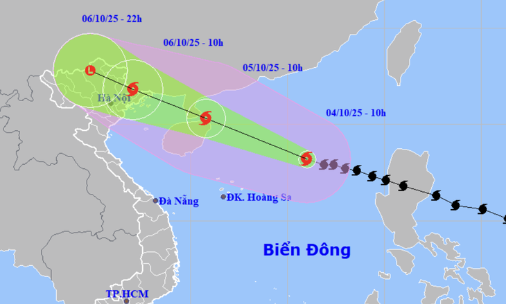
Forecast of the location and trajectory of Typhoon Matmo at 10:00 AM on October 4th - Photo: NCHMF
On the morning of October 4th, the Northern Vietnam Meteorological and Hydrological Station forecasted the potential impact of Typhoon Matmo on Hanoi city.
Be prepared for heavy rain causing urban flooding.
According to forecasts, from early morning on October 6th, the Hanoi area will experience increasingly strong winds, reaching levels 4-5. From early morning on October 6th to the evening of October 7th, Hanoi will experience moderate to heavy rain, with some areas experiencing very heavy rain and thunderstorms.
Total rainfall in the city center, western and northern areas of the city is generally 80-150mm, with some places exceeding 150mm.
In the southern part of the city, rainfall is commonly 50-100mm, with some areas receiving over 100mm.
The National Center for Meteorological and Hydrological Forecasting predicts that the Hanoi area is unlikely to be affected by strong winds and storms.
The forecast from early morning on October 6th until the end of October 7th predicts moderate to heavy rain, with rainfall amounts generally ranging from 70-120mm, and in some localized areas exceeding 150mm.
The Northern Vietnam Meteorological and Hydrological Center warns that heavy rainfall in a short period of time will overload the drainage system, causing flooding in residential areas, urban areas, and low-lying areas, traffic congestion due to flooded roads, reduced visibility for drivers, and increased risk of slips and traffic accidents.
During thunderstorms, phenomena such as tornadoes, lightning, and strong gusts of wind can cause trees to fall, damage houses, transportation infrastructure, and other facilities.
Latest developments regarding Hurricane Matmo
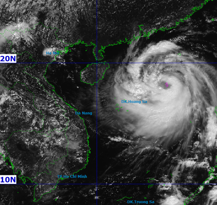
Satellite image of Hurricane Matmo at 11 am today - Photo: NCHFM
At 11:00 AM today, the center of Typhoon Matmo was approximately 390km east-northeast of the Hoang Sa Special Administrative Region. The maximum wind speed was level 11 (103-117km/h), with gusts up to level 14.
Forecasts indicate that over the next 24 hours, the storm will move towards the Leizhou Peninsula (China), potentially strengthening by two levels to level 13 (134-149 km/h), with gusts up to level 16.
Around late tomorrow evening, the storm will cross the Leizhou Peninsula and enter the Gulf of Tonkin, likely weakening in intensity. Afterward, the storm is likely to move into the northeastern region of Vietnam in the early morning of October 6th.
Due to the influence of the storm, in the northern South China Sea area, there are strong winds of force 8-10, reaching force 11-13 near the storm's center, with gusts up to force 16, and sea waves 4-6m high, reaching 6-8m near the storm's center.
From the afternoon of October 5th, the sea area east of the northern Gulf of Tonkin (including the Bach Long Vi special zone) will experience increasingly strong winds, reaching levels 6-7, and then increasing to levels 8-9.
From the evening of October 5th, the northern part of the Gulf of Tonkin (including the Bach Long Vi, Van Don, Co To, Cat Hai special zones and Hon Dau island) will experience increasingly strong winds of force 8-9, with waves 2-4m high. In areas near the storm's center, winds will reach force 10-11, with gusts up to force 14, and waves 3-5m high.
Coastal areas and islands in Quang Ninh and Hai Phong provinces will experience storm surges of 0.4-0.6m. Be prepared for flooding in low-lying coastal areas and river mouths due to storm surges and large waves from the afternoon and evening of October 5th to 10th.
On land, from the night of October 5th to 10th, in the coastal areas from Quang Ninh to Hung Yen, winds will gradually strengthen to level 6-7, reaching level 8-9 (62-88 km/h) in areas near the storm's center - winds at this level can break tree branches and tear off roofs, causing damage to houses.
In the inland areas of the Northeast, there will be strong winds of level 4-5, with some places reaching level 6, and gusts of level 7-8.
From the night of October 5th to the night of October 7th, heavy rain fell in the mountainous and midland areas of Northern Vietnam, with rainfall generally ranging from 150-250mm, and in some localized areas receiving very heavy rain exceeding 400mm.
Warning of the risk of heavy rainfall exceeding 150mm in 3 hours. The Northern Delta region and Thanh Hoa province will experience moderate to heavy rain with rainfall amounts generally ranging from 70-150mm, and some areas experiencing very heavy rain exceeding 200mm.
Due to the influence of the wide storm circulation, there is a risk of thunderstorms, tornadoes, and strong gusts of wind both before and during the storm's landfall.
Source: https://tuoitre.vn/bao-matmo-lieu-co-gay-mua-lut-o-ha-noi-20251004115744617.htm
![[Photo] Secretary of the National Assembly Party Committee, Chairman of the National Assembly presides over the meeting of the Standing Committee and Executive Committee of the National Assembly Party Committee.](https://vphoto.vietnam.vn/thumb/1200x675/vietnam/resource/IMAGE/2026/06/03/1780480353201_ndo_br_bnd-2585-jpg.webp)


![[Photo] General Secretary and President To Lam presides over a meeting with the Central Organizing Committee.](https://vphoto.vietnam.vn/thumb/1200x675/vietnam/resource/IMAGE/2026/06/03/1780482764658_a1-bnd-4741-3342-jpg.webp)

![[Photo] First session of the 14th Congress of the Vietnam Trade Union](https://vphoto.vietnam.vn/thumb/1200x675/vietnam/resource/IMAGE/2026/06/03/1780465947883_ndo_br_img-3852-jpg.webp)


![[Video] Sunset at Lap An Lagoon – Where the sun sets over the fishing nets](https://vphoto.vietnam.vn/thumb/1200x675/vietnam/resource/IMAGE/2026/05/31/1780192137701_beach-landscape-sea-water-nature-grass-745871-pxhere-com.jpeg)


Comment (0)