
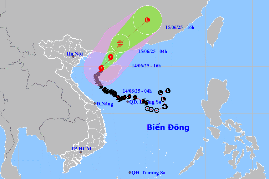
According to the National Center for Hydro-Meteorological Forecasting, at 4:00 a.m. on June 14, the center of storm No. 1 was located at about 19.8 degrees North latitude, 108.9 degrees East longitude, in the eastern sea of the Gulf of Tonkin, about 150 km east of Bach Long Vi Island ( Hai Phong ).
The strongest wind near the storm center is level 10 - 11 (89 - 117 km/h), gusting to level 13. The storm is moving north at a speed of 5 km/h.
Due to the influence of storm No. 1, Bach Long Vi island district has strong winds of level 7, gusting to level 8-9; Con Co island district (Quang Tri) has strong winds of level 7, gusting to level 8; Bai Chay and Cua Ong areas ( Quang Ninh ) have strong winds of level 6.
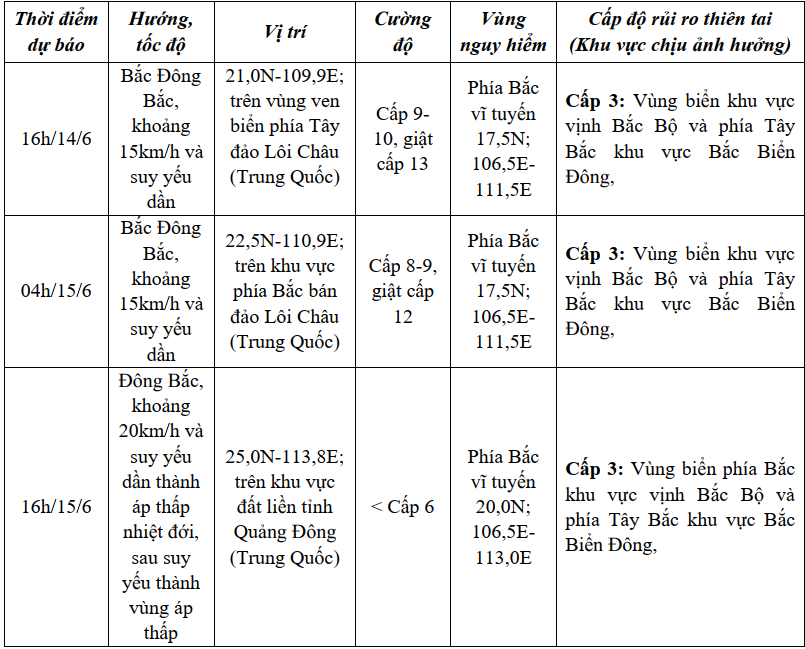
It is forecasted that due to the impact of the storm, the Gulf of Tonkin (including Co To and Bach Long Vi island districts) will have strong winds of level 7, the area near the storm's center will have winds of level 8-9, gusting to level 13. Waves will be 2-4 m high, especially in the East 4-6 m. The sea will be very rough.
Northwest of East Sea area has strong wind level 6, gust level 8, waves 2-4 m high. Rough sea.
Ships in danger zones are at risk of storms, whirlwinds, strong winds and large waves.
On land, the coastal area of Quang Ninh - Hai Phong has strong winds of level 6, gusting to level 8; the coastal area of Thai Binh - Nam Dinh has strong winds of level 4 - 5, gusting to level 6 - 7.
Due to the impact of storm No. 1, on June 14, Hai Duong area is forecast to have scattered showers and thunderstorms, locally heavy rain and thunderstorms. Rainfall is generally from 10 - 20 mm, in some places more than 30 mm. During the storm, there is a possibility of tornadoes, lightning and strong gusts of wind.
It is forecasted that in the next 48 - 72 hours, storm No. 1 will no longer be able to affect Hai Duong.
TBSource: https://baohaiduong.vn/bao-so-1-giat-cap-13-tren-bien-hai-duong-co-mua-rao-va-dong-rai-rac-414027.html


Comment (0)