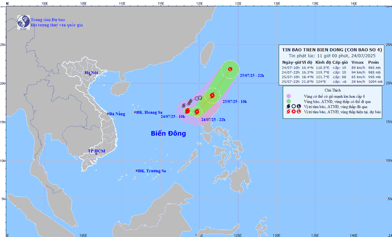
Image of storm No. 4 's path at noon on July 24
According to the National Center for Hydro-Meteorological Forecasting, at 10:00 a.m. on July 24, the center of the storm was located at 16.4°N; 118.5°E, in the eastern sea of the North East Sea.
Intensity: level 9–10 (75–102km/h), gust level 12.
The storm is moving southeast at about 10km/h.
It is forecasted that by 7:00 p.m. on July 24, the storm will move eastward at a speed of about 10 km/h, operating in the eastern sea of the North East Sea. At this time, the center of the storm is at about 16.3 degrees North latitude - 119.5 degrees East longitude, with the strongest wind at level 9, gusting to level 12.
At 7:00 a.m. on July 25, the storm moved faster in a northeast direction at a speed of 20-25 km/h, with its center located at approximately 18.2 degrees North latitude - 121.2 degrees East longitude, in the northern area of Luzong Island (Philippines). The storm intensity decreased to level 8, gusting to level 10.
At 7:00 a.m. on July 26, the storm continued to move northeast at a speed of 25-30 km/h, then gradually weakened into a low pressure area.
Due to the impact of the storm, the eastern sea area of the North East Sea has strong winds of level 7-8, near the center of the storm are strong winds of level 9-10, gusts of level 12; waves are 4-6m high. The sea is very rough. Ships operating in the above-mentioned dangerous areas are likely to be affected by storms, whirlwinds, strong winds, and large waves.
The sea area from Lam Dong to Ca Mau (including the sea area of Ho Chi Minh City) has southwest wind level 5, especially in the North level 6, gusting to level 7-8. Wave height 1.5-3m, rough sea. The sea area from Ca Mau - An Giang and Phu Quoc has southwest wind level 4, sometimes level 5. Wave height 0.75-2m, the sea is sometimes slightly rough. In both sea areas, the weather has scattered showers and thunderstorms. During thunderstorms, beware of tornadoes and strong gusts of wind.
According to the Southern and Central Highlands Hydrometeorological Station, the tropical convergence zone over the Northern region will continue to connect with storm No. 4. Due to the indirect influence of storm No. 4, the southwest monsoon (the cause of rain in the South and Central Highlands) is operating at medium to strong intensity.
Thu Cuc
Source: https://baochinhphu.vn/bao-so-4-co-may-it-co-kha-nang-anh-huong-den-dat-lien-nuoc-ta-102250724113542645.htm






















Comment (0)