
 |
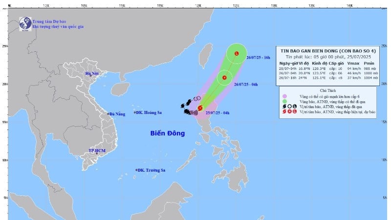
| (Photo: National Center for Hydro-Meteorological Forecasting) |
According to the National Center for Hydro-Meteorological Forecasting, at 4:00 a.m., the eye of the storm was located at about 16.8 degrees north latitude; 120.3 degrees east longitude, in the area west of Lu Island (Philippines). The strongest wind near the eye of the storm was level 9-10 (75-102 km/h), gusting to level 12; moving northeast at a speed of about 10 km/h.
It is forecasted that by 4 a.m. on July 26, storm No. 4 will move northeast at about 20-25 km/hour and gradually weaken over the sea northeast of Lu Dong Island. By 4 p.m. on the same day, the storm will continue moving northeast at 25-30 km/hour, gradually weakening into a low pressure area.
At sea, today (July 25), the eastern sea area of the northern East Sea has strong winds of level 7-8, near the storm center strong winds of level 9-10, gusts of level 12; waves 4-6m high. The sea is very rough. Ships operating in the above-mentioned dangerous areas are likely to be affected by storms, whirlwinds, strong winds, and large waves.
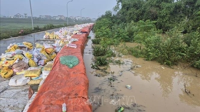
Warning of flash floods, landslides, and land subsidence due to heavy rain or water flow in the provinces of Dien Bien , Son La, and Tuyen Quang
In the past 6 hours (from 11pm on July 24 to 5am on July 25), the provinces of Dien Bien, Son La and Tuyen Quang had moderate rain, heavy rain, and very heavy rain in some places such as: Muong Tung 149.4mm, Lay Nua 104.4mm (Dien Bien); Tan Lap 144.8mm, Chieng Lao 123.4mm (Son La); Ho Thau 80.2mm, Nam Dan 63.8mm (Tuyen Quang);...
Soil moisture models show that some areas in the above provinces are close to saturation (over 85%) or have reached saturation.
It is forecasted that this morning, the above provinces will continue to have rain with common accumulated rainfall as follows: Dien Bien and Son La provinces from 20-50mm, some places over 100mm; Tuyen Quang from 10-30mm, some places over 70mm.
In the next 6 hours, there is a risk of flash floods on small rivers and streams, landslides on steep slopes in many communes and wards in the above provinces such as Muong Tung; Muong Lay Ward, Pu Nhung, Sang Nhe; Cha To, Muong Cha, Na Bung, Na Hy, Na Sang, Nam Ke, Nam Nen, Pa Ham, Quang Lam, Si Pa Phin, Sin Chai, Sinh Phinh, Tua Thang (Son La);
Chieng Lao; Muong Chien, Muong Gion, Muong Khieng, Muong La, Muong Sai, Moc Chau ward, Quynh Nhai, Tan Yen; Binh Thuan, Bo Sinh, Chieng Hac, Chieng Hoa, Chieng Khuong, Chieng La, Chieng Mai, Chieng Mung, Chieng Sai, Co Ma, Doan Ket, Kim Bon, Long He, Long Phieng, Long Sap, Mai Son, Muoi Noi, Muong Bu, Muong Chanh, Muong E, Muong Hung, Muong Lam, Nam Lau, Nam Ty, Chieng An ward, Chieng Coi ward, Chieng Sinh ward, Moc Son ward, Thao Nguyen ward, To Hieu ward, Van Son ward, Phieng Cam, Phieng Khoai, Phieng Pan, Phu Yen, Ta Hoc, Ta Khoa, Tan Phong, Thuan Chau, To Mua, Tuong Ha, Yen Chau (Son La);
Hong Thai; Binh An, Binh Xa, Con Lon, Dong Yen, Ham Yen, Ho Thau, Hung An, Lam Binh, Minh Quang, Na Hang, Nam Dan, Pa Vay Su, Thai Son, Thuong Lam, Thuong Nong, Tien Yen, Yen Cuong, Yen Hoa (Tuyen Quang).
Flash floods and landslides can have very negative impacts on the environment, threaten people's lives; cause local traffic congestion, affect the movement of vehicles; destroy civil and economic works, causing damage to production and socio-economic activities.
The meteorological agency recommends that local authorities pay attention to reviewing bottlenecks and vulnerable locations in the area to take preventive and response measures.
Source: https://huengaynay.vn/chinh-tri-xa-hoi/theo-dong-thoi-su/bao-so-4-dang-giat-cap-12-gan-bien-dong-du-bao-suy-yeu-vao-chieu-mai-156049.html


![[Photo] Discover unique experiences at the first World Cultural Festival](https://vphoto.vietnam.vn/thumb/1200x675/vietnam/resource/IMAGE/2025/10/11/1760198064937_le-hoi-van-hoa-4199-3623-jpg.webp)


![[Photo] General Secretary attends the parade to celebrate the 80th anniversary of the founding of the Korean Workers' Party](https://vphoto.vietnam.vn/thumb/1200x675/vietnam/resource/IMAGE/2025/10/11/1760150039564_vna-potal-tong-bi-thu-du-le-duyet-binh-ky-niem-80-nam-thanh-lap-dang-lao-dong-trieu-tien-8331994-jpg.webp)


Comment (0)