

At 4:00 a.m. on August 25, the center of the storm was at approximately 18.3 degrees North latitude; 107.7 degrees East longitude, approximately 220 km from Nghe An, approximately 200 km East Southeast of Ha Tinh, approximately 180 km East Northeast of Quang Tri. The strongest wind near the center of the storm was level 14 (150-166 km/h), gusting to level 17; moving West Northwest at approximately 20 km/h.
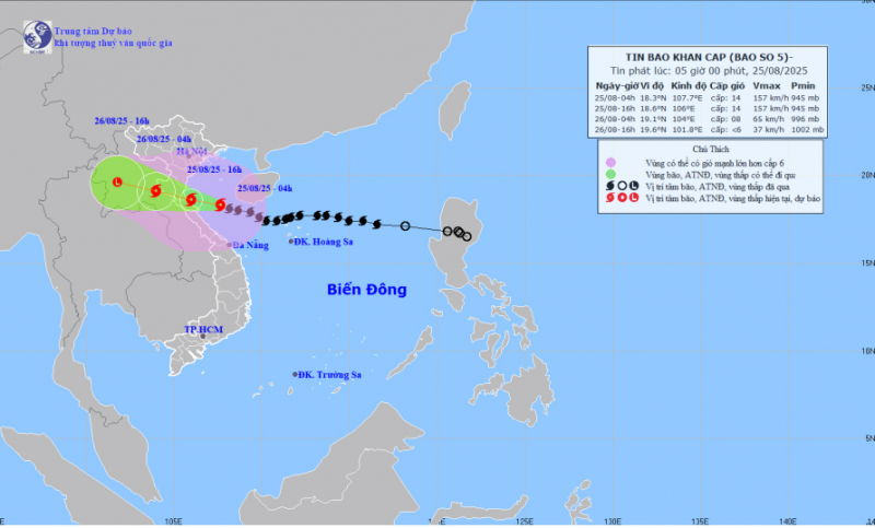
It is forecasted that in the next 12 hours, the storm will continue to move in the West Northwest direction at a speed of about 20km/h. At about 4:00 p.m. this afternoon, the storm will be on the coastal sea from Thanh Hoa to Northern Quang Tri with a strong intensity of level 14, gusting to 17. The affected area includes the Northern Gulf of Tonkin, the sea area from Thanh Hoa to Quang Tri (including Hon Ngu Island, Con Co special zone) with a disaster risk level of level 3. Meanwhile, the coastal sea area from Thanh Hoa to Quang Tri has a disaster risk level of level 4.
Affected by the storm, the western sea area of the North East Sea today has strong winds of level 6-7, gusts of level 9, waves 3.0-5.0m high, rough seas. The sea area from Thanh Hoa to Quang Tri (including Hon Ngu island, Con Co special zone) has strong winds of level 7-9, then increasing to level 10-11, near the eye of the storm level 12-14, gusts of level 17; waves 5.0-7.0m high, near the eye of the storm 8.0-10.0m; rough seas. The northern Gulf of Tonkin (including the special zones: Cat Hai, Co To, Van Don) has strong winds of level 6-7, gusts of level 9; the southern area of the northern Gulf of Tonkin (including the special zone Bach Long Vi) has strong winds of level 8-9, gusts of level 11; waves 3.0-5.0m high; very rough seas.

Meteorological experts warn that the weather at sea and in coastal areas during the storm is extremely dangerous and unsafe for any vehicles or structures operating in the danger zone such as: cruise ships, passenger ships, cargo ships, cages, rafts, aquaculture areas, dykes, embankments, and coastal routes. Vehicles are at high risk of capsizing and being destroyed; being flooded due to strong winds, big waves, and rising sea levels.
Weather in regions across the country on Monday (August 25), Hanoi capital is cloudy, with moderate rain, heavy rain and thunderstorms, locally very heavy rain. North to northeast wind level 3-4. Lowest temperature 23-25 degrees. Highest temperature 27-29 degrees.
Northwest cloudy, rain, moderate rain and scattered thunderstorms, locally heavy to very heavy rain. Light wind. Lowest temperature 21-24 degrees, some places below 21 degrees. Highest temperature 28-31 degrees.
The Northeast region is cloudy, with moderate rain, heavy rain and scattered thunderstorms in the plains and midlands, with some places having very heavy rain; scattered showers and thunderstorms in the mountainous areas, with some places having heavy rain. North to northeast wind level 3-4; in coastal areas from Quang Ninh to Ninh Binh, the wind gradually increases to level 6-8, gusting to level 9-10. Lowest temperature 22-25 degrees. Highest temperature 27-29 degrees, in mountainous areas 29-31 degrees, in some places over 31 degrees.
From Thanh Hoa to Hue, it is cloudy with moderate to heavy rain and scattered thunderstorms, with some places experiencing very heavy rain; from Thanh Hoa to Northern Quang Tri, there will be heavy to very heavy rain. The wind will gradually increase to level 8-11, near the storm center level 12-14, gusting to level 15-16; in Hue, the wind will be from the west to the southwest level 4-5. The lowest temperature is 23-25 degrees. The highest temperature is 26-29 degrees, with some places above 29 degrees.
The South Central Coast is cloudy with scattered showers and thunderstorms, with scattered showers and thunderstorms in the afternoon and evening, with some heavy rain in some places; Da Nang and eastern Quang Ngai have rain, moderate rain and thunderstorms. Southwesterly winds level 3-4. Lowest temperature 24-27 degrees. Highest temperature 30-33 degrees.
The Central Highlands is cloudy with scattered showers and thunderstorms, with some places experiencing heavy rain; in the western part of Quang Ngai, there will be rain, moderate rain and scattered thunderstorms, with some places experiencing heavy rain. Southwesterly wind level 3. Lowest temperature 19-22 degrees. Highest temperature 25-28 degrees, with some places experiencing over 28 degrees.
The South is cloudy with scattered showers and thunderstorms, with scattered showers and thunderstorms in the afternoon and evening, and heavy rain in some places. Southwesterly wind level 3. Lowest temperature 23-26 degrees. Highest temperature 29-32 degrees.
Ho Chi Minh City is cloudy with scattered showers and thunderstorms, with scattered showers and thunderstorms in the afternoon and evening, and heavy rain in some places. Southwesterly wind level 3. Lowest temperature 24-26 degrees. Highest temperature 29-31 degrees.
Source: https://cand.com.vn/doi-song/bao-so-5-do-bo-bac-bo-den-trung-bo-mua-rat-to-i779168/


![[Photo] General Secretary To Lam attends the 80th anniversary of Vietnam's diplomacy](https://vphoto.vietnam.vn/thumb/1200x675/vietnam/resource/IMAGE/2025/8/25/3dc715efdbf74937b6fe8072bac5cb30)


Comment (0)