

According to the Center for Hydro-Meteorological Forecasting, due to the influence of storm No. 9 Ragasa, in Bach Long Vi special zone there were strong winds of level 7, gusting to level 8.
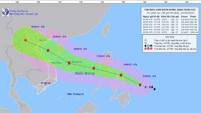
The center of the storm at 6:00 a.m. on September 25 was at about 21.5 degrees North latitude; 109.1 degrees East longitude, about 120km east of Mong Cai ( Quang Ninh ).
The strongest wind is level 09 (75 - 88km/h), gusting to level 11.
Forecast, in the next 3 hours, the storm will move west, speed about 20km/h.
Forecast in the next 24 hours, storm Ragasa moves westward, at a speed of about 20km/h, gradually weakening into a tropical depression.
Due to the impact of the storm, the northwestern sea area of the North East Sea has strong winds of level 6-8, gusts of level 10, waves 3.0-5.0m high; rough seas.
The Northern Gulf of Tonkin area (including Bach Long Vy, Van Don, Co To, Cat Hai and Hon Dau islands) has strong winds of level 6-7, waves 2.0-3.0m high, near the storm center level 8-9, gusts of level 11, waves 3.0-4.0m high; very rough seas.
Coastal areas from Quang Ninh to Hai Phong have winds gradually increasing to level 6-7, near the storm center level 8, gusting to level 9-10; inland areas in the Northeast, there are strong winds of level 5, in some places level 6, gusting to level 7-8.
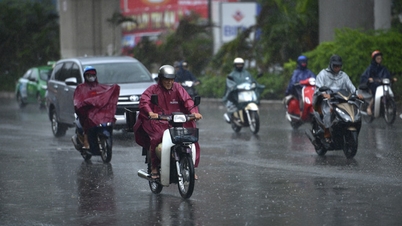
From early morning of September 25 to the end of the night of September 26, in the Northern region, Thanh Hoa and Nghe An, there will be heavy to very heavy rain with common rainfall of 150-300mm, locally over 450mm. Beware of heavy rain causing urban flooding.
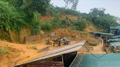
From September 25 to September 27, there is a possibility of a flood on rivers in the Northern region, Thanh Hoa, and Nghe An. The flood peak on Thao River and small rivers is likely to reach level 2-3; the flood peak on Lo River, upstream of Thai Binh River, Hoang Long River, Buoi River, upstream of Ma River will reach level 1-2, with some rivers above level 2.
Source: https://baolaocai.vn/bao-so-9-ragasa-giam-xuong-cap-9-giat-cap-11-cach-mong-cai-khoang-120km-post882861.html


Comment (0)