
Storm No. 9 (Ragasa) is forecast to maintain wind speed of level 16-17 when entering the East Sea, causing heavy rain and strong winds in the North and North Central regions. Deputy Minister of Agriculture and Environment Nguyen Hoang Hiep requested localities to proactively harvest rice, protect crops, and strengthen communication and disaster warnings.
 |
| Deputy Minister of Agriculture and Environment Nguyen Hoang Hiep gave a speech at a meeting to respond to storm Ragasa late on the afternoon of September 22. |
Storm No. 9: Extremely strong intensity, risk of major impact
Reporting at the emergency meeting to respond to storm No. 9 late in the afternoon of September 22, Mr. Mai Van Khiem, Director of the National Center for Hydro-Meteorological Forecasting, shared: Storm Ragasa will certainly become storm No. 9 of 2025. At 5:00 p.m. on September 22, the center of the storm was at about 19.4 degrees North latitude; 121.7 degrees East longitude, only 100km-120km from the East Sea. Maximum wind speed remained at level 17 (210km/h-230km/h), gusting above level 17.
Analysis of satellite images and data from Philippine monitoring stations shows that the convective cloud system around the storm is very strong, with cloud tops reaching -75°C to -80°C, while the eye of the storm is "hot" at more than 15°C. The large temperature difference allows the storm circulation to maintain its maximum strength, with the storm's wind range extending for hundreds of kilometers.
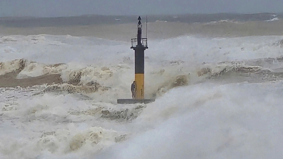
In the next 6 hours, the storm will maintain its intensity at level 17, and may then remain at level 16-17 until September 23. In particular, the strong wind will be at level 15-17, gusting above level 17, posing a serious danger to vessels operating at sea. Waves near the storm's center will be over 10m high; in the Gulf of Tonkin, strong winds of level 11-12, waves of 5m-7m high are forecast, the most dangerous from morning to night of September 25.
The Director of the National Center for Hydro-Meteorological Forecasting forecasts: The path shows that Ragasa storm will move in the Northwest-Northwest direction, most likely directly affecting the southern area of Guangdong province (China), then possibly entering the northern part of the Gulf of Tonkin. If the storm deviates to the north and weakens over mainland China, the impact on our country will be reduced. However, in the scenario of the storm entering the Gulf of Tonkin, the Northern and North Central provinces will be clearly affected.
 |
| Mai Van Khiem, Director of the National Center for Hydro-Meteorological Forecasting, shares about the developments of storm Ragasa. |
Regarding rain, from the night of September 24 to September 26, the North and North Central regions are forecast to have widespread rain of 100mm-150mm. Key areas such as Thai Nguyen, Tuyen Quang, Lao Cai, Phu Tho, the Northern Delta, Thanh Hoa, Nghe An will have rain of 200mm-250mm, locally over 450mm. Prolonged heavy rain increases the risk of flooding on the Thao, Lo, Hoang Long rivers, the Thai Binh river system, and the Ma and Ca rivers; it is possible to reach alert levels II-III in the upper reaches. Small rivers in the northern mountainous areas are at risk of flash floods and landslides.
On the northern coast, due to low tide, the storm surge is forecast to be under 1 meter, but waves combined with strong winds still pose a direct threat to areas from Quang Ninh to Thanh Hoa. On land, strong winds are concentrated in Quang Ninh-Thanh Hoa, possibly reaching level 9-10, gusting to level 12-14.
Mr. Khiem noted that Ragasa is different from Typhoon Yagi in 2024. While Yagi maintains its strength due to the additional moisture, Ragasa encounters dry air from the northern continental high pressure, and is forecast to gradually weaken when it enters mainland China. However, during its active phase in the East Sea, Ragasa is still a very strong typhoon, with the potential to have a major impact on our country.
Response instructions: Protect crops, increase warnings
Faced with the complicated developments of storm No. 9, Deputy Minister of Agriculture and Environment Nguyen Hoang Hiep emphasized: Currently, flood and storm prevention work has been professionally organized, so we must have a firm grasp of the situation to have a more comprehensive and effective solution.
“At this point, it can be confirmed that storm No. 9, when entering the East Sea, will be the strongest storm in the world in 2025 according to current measurements. This is also the strongest storm ever recorded in history in the East Sea region,” Mr. Hiep emphasized.
The Deputy Minister also said that it is forecasted that in the early morning of September 23, around 1-2 a.m., the storm will officially enter the East Sea. According to the current scenario, when entering the East Sea, due to some unfavorable factors, the storm may gradually decrease in intensity. It is forecasted that from the early morning of September 25, the storm will begin to affect the Gulf of Tonkin, then linger there, and then make landfall at noon or early afternoon of September 25. When entering the Gulf of Tonkin, the storm is likely to maintain level 9-10, gusting to level 12-14; when making landfall, the intensity will be around level 8-9, gusting to level 11-12.
 |
| Deputy Minister of Agriculture and Environment Nguyen Hoang Hiep directed at the meeting. |
However, he said this is just a forecast, the accuracy is not high. Therefore, the storm may be stronger or weaker, but it will definitely affect Vietnam, first of all at sea. Therefore, the first thing is to strictly control the activities of ships.
The leader of the Ministry of Agriculture and Environment said that the Prime Minister has issued Official Dispatch 170, requesting the Border Guard, Construction, Transport, and Fisheries forces to coordinate in controlling and not allowing boats to set sail from today without management and counting.
The second issue is aquaculture cages. Currently, the Northern, North Central and coastal regions have about 165,000 hectares of aquaculture, a very large number that needs to be strictly controlled.
The next concern is heavy rain and reservoir safety. According to current procedures, hydroelectric and irrigation reservoirs are at the end of the main flood season, many of which are almost full. If the storm causes 150mm-450mm of rain, operations will be very difficult. Therefore, it is necessary to closely monitor meteorological bulletins to determine appropriate flood discharges, avoiding passive situations like some previous years.
In addition, this storm has very strong intensity, wide circulation, combined with cold air that can cause extreme weather phenomena such as thunderstorms, tornadoes, lightning, local heavy rain... It is difficult to forecast accurately, so it is necessary to warn ships immediately, especially in the Gulf of Tonkin.
Another important issue is the crop. There are currently more than 810,000 hectares of rice, of which only about 200,000 hectares have been harvested, and more than 600,000 hectares are still green. If a storm hits, the damage will be huge. Therefore, localities need to urgently harvest the ripe rice area and proactively take measures to protect crops and fruit trees.
Finally, regarding forecasting and communication: this is a very strong storm, requiring a different approach. The Hydrometeorological Center is requested to issue bulletins every 3 hours. At the same time, closely coordinate with the press and media to provide accurate and timely information to the people; avoid subjectivity or excessive reporting that causes panic.
It is necessary to promote the 112 hotline so that people know and call when they need support from natural disasters. This is a very important communication channel but many people do not fully understand it.
We will continue to monitor the situation to advise the Government and the Prime Minister, and coordinate with localities to respond.
According to Thanh Tra/nhandan.vn
Source: https://baovinhlong.com.vn/thoi-su/202509/bao-so-9-ragasa-tien-vao-bien-dong-voi-cuong-do-cuc-manh-yeu-cau-ung-pho-khan-cap-9c51807/
![[Photo] High-ranking delegation of the Russian State Duma visits President Ho Chi Minh's Mausoleum](https://vphoto.vietnam.vn/thumb/1200x675/vietnam/resource/IMAGE/2025/9/28/c6dfd505d79b460a93752e48882e8f7e)

![[Photo] The 4th meeting of the Inter-Parliamentary Cooperation Committee between the National Assembly of Vietnam and the State Duma of Russia](https://vphoto.vietnam.vn/thumb/1200x675/vietnam/resource/IMAGE/2025/9/28/9f9e84a38675449aa9c08b391e153183)


![[Photo] National Assembly Chairman Tran Thanh Man presided over the welcoming ceremony for Chairman of the State Duma of the Russian Federation Vyacheslav Volodin](https://vphoto.vietnam.vn/thumb/1200x675/vietnam/resource/IMAGE/2025/9/28/889b54ac5cd440099ddc618c99663612)


Comment (0)