
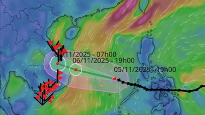
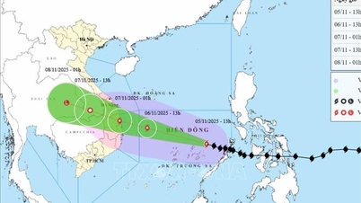
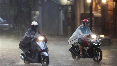
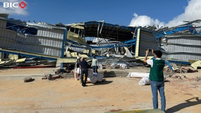
On the afternoon of September 28 in Hanoi , the Department of Hydrometeorology held a meeting to provide information on the situation of storm No. 10 (Bualoi). Speaking to the press, Mr. Hoang Phuc Lam, Deputy Director of the National Center for Hydrometeorology Forecasting, said that storm No. 10 is approaching the coast of Quang Tri - Hue with the strongest wind speed of level 12, gusting to level 15.

Mr. Hoang Phuc Lam warned: “At about 1:00 a.m. on September 29, the eye of the storm will reach the shore. However, the area most affected by wind and rain has started from the evening of September 28 and will last until the early morning of September 29, in which the most dangerous peak is from 4 to 5 a.m.”
According to a representative of the National Center for Hydro-Meteorological Forecasting, the special thing to note about this storm is that it shows signs of slowing down. “If the storm slows down, strong winds and heavy rains will last longer, and the risk of roofs being blown off, trees being broken, flooding and landslides will be more serious. A slow-moving storm also has the potential to change its structure, trajectory and intensity,” warned Mr. Hoang Phuc Lam.
Updated at 5:00 p.m. on September 28, the center of storm No. 10 was at coordinates of about 17.5 degrees North latitude - 107.6 degrees East longitude, about 110km east of North Quang Tri . At this time, the storm is still strong at level 12, gusting to level 15. The National Center for Hydro-Meteorological Forecasting forecasts that in the next 3 hours, the storm will move in a West-Northwest direction, at a speed of about 20-25km/hour (significantly slower than 2-3 days ago, but still faster than usual).

According to experts from the National Center for Hydro-Meteorological Forecasting, the key area directly affected is from Thanh Hoa to Northern Quang Tri with a level 4 natural disaster risk. According to forecasts, coastal winds can be as strong as level 10-12, with heavy rains of over 200mm in just 3 hours, with a high risk of flash floods, landslides in mountainous areas and widespread flooding in urban areas.
“People in the eye of the storm must not be complacent. The storm has very strong winds and its developments are more complicated due to its slowing down,” Mr. Hoang Phuc Lam emphasized.
Source: https://www.sggp.org.vn/bao-so-10-do-bo-dat-lien-4-5-gio-sang-la-thoi-diem-nguy-hiem-nhat-post815243.html

![[Photo] Prime Minister Pham Minh Chinh meets with representatives of outstanding teachers](https://vphoto.vietnam.vn/thumb/1200x675/vietnam/resource/IMAGE/2025/11/15/1763215934276_dsc-0578-jpg.webp)


![[Photo] General Secretary To Lam receives Vice President of Luxshare-ICT Group (China)](https://vphoto.vietnam.vn/thumb/1200x675/vietnam/resource/IMAGE/2025/11/15/1763211137119_a1-bnd-7809-8939-jpg.webp)


Comment (0)