
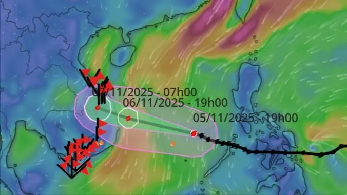
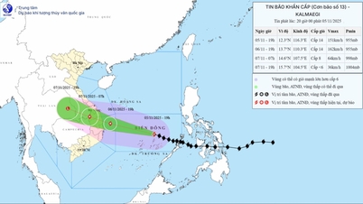
At 7:00 p.m. on November 5, the center of the storm was at about 12.3 degrees North latitude; 116.3 degrees East longitude, about 240km East Northeast of Song Tu Tay Island, about 800km East Southeast of Quy Nhon ( Gia Lai ). The strongest wind near the center of the storm was level 14 (150-166 km/h), gusting to level 17. Moving in the West Northwest direction, speed about 25km/h.
It is forecasted that by 7 p.m. on November 6, the storm will be about 120 km east-southeast of Quy Nhon (Gia Lai) and moving in a West-Northwest direction at a speed of about 25 km/h. The storm has a level 14 intensity, gusting to level 17. The affected areas are the middle of the East Sea (including the sea area north of Truong Sa special zone), the offshore sea area from Quang Ngai to Dak Lak (including Ly Son special zone); the mainland east of the area from Quang Ngai to Dak Lak with a disaster risk level of level 4. The sea area from South Quang Tri to Da Nang (including Cu Lao Cham island) and Khanh Hoa; the mainland south of Quang Tri to Da Nang and the area north of Khanh Hoa province have a disaster risk level of level 3.
At 7:00 a.m. on November 7, the storm was moving in the West Northwest direction on the border area of Quang Ngai province - Southern Laos, at a speed of about 25 km/h. The storm had a level 8 intensity, gusting to level 10. The affected areas were the western sea area of the Central East Sea, the sea area from Quang Ngai to Dak Lak (including Ly Son special zone); the eastern mainland area from Quang Ngai to Dak Lak with a disaster risk level of level 4. The sea area from Southern Quang Tri to Da Nang (including Cu Lao Cham island) and Khanh Hoa; the mainland from Southern Quang Tri to Da Nang, the western provinces from Quang Ngai to Dak Lak; the northern area of Khanh Hoa province had a disaster risk level of level 3.

At 7 p.m. on November 7, the storm was on the eastern mainland of Thailand, moving west-northwest at a speed of about 25 km/h. The storm moved inland and weakened into a tropical depression, then a low pressure area.
Due to the impact of the storm, at sea, the Central East Sea area (including the sea area north of Truong Sa special zone) has strong winds of level 8-11; the area near the storm's eye has strong winds of level 12-14, gusts of level 17, waves 5-7m high, the area near the storm's eye has waves of 8-10m high; the sea is very rough.
From early morning on November 6, the sea area from South Quang Tri to Khanh Hoa (including Ly Son special zone, Cu Lao Cham island) will have winds gradually increasing to level 6-7, then increasing to level 8-11, waves 3-5m high; the area near the storm center will have winds of level 12-14, gusting to level 17, waves 6-8m high; the sea will be very rough.
Coastal areas from Hue to Dak Lak have storm surges of 0.3-0.6m high.
Warning: From the evening of November 6, coastal areas from Hue to Dak Lak should be on guard against rising sea levels accompanied by large waves causing flooding in low-lying areas, waves overflowing dikes, coastal roads, coastal erosion, slowing down flood drainage in the area. All ships, boats, and aquaculture areas in the above-mentioned dangerous areas are strongly affected by storms, whirlwinds, strong winds, large waves, and rising sea levels.
On land, from the evening of November 6, on the mainland along the coast from South Quang Tri to Da Nang, the eastern part of the provinces from Quang Ngai to Dak Lak, the wind will gradually increase to level 6-7, then increase to level 8-9, the area near the storm's eye will be strong at level 10-12 (focusing on the eastern part of Quang Ngai - Dak Lak provinces), gusting to level 14-15.
From the evening and night of November 6, in the West of the provinces from Quang Ngai to Dak Lak, the Northern area of Khanh Hoa province, the wind will gradually increase to level 6-7, the area near the storm's eye will be level 8-9, gusting to level 11.
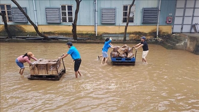
In addition, from November 6 to 7, the area from Da Nang to Dak Lak will have very heavy rain with common rainfall of 200-400mm/period, locally over 600mm/period; the area from South Quang Tri to Hue, Khanh Hoa and Lam Dong will have heavy rain with common rainfall of 150-300mm/period, locally over 450mm/period. From November 8, heavy rain in the above areas will tend to decrease.
From November 7 to 8, the area from North Quang Tri to Thanh Hoa will have moderate to heavy rain with common rainfall of 50-150mm/period, locally very heavy rain over 200mm/period. Warning of risk of heavy rain (over 200mm/3 hours).
Due to the influence of the wide storm circulation, it is necessary to guard against the risk of thunderstorms, tornadoes and strong gusts of wind both before and during the storm's landfall.
Source: https://www.sggp.org.vn/bao-so-13-tiep-tuc-di-chuyen-nhanh-vao-dat-lien-quang-ngai-den-dak-lak-post821928.html


![[Photo] Opening of the 14th Conference of the 13th Party Central Committee](https://vphoto.vietnam.vn/thumb/1200x675/vietnam/resource/IMAGE/2025/11/05/1762310995216_a5-bnd-5742-5255-jpg.webp)


![[Photo] Panorama of the Patriotic Emulation Congress of Nhan Dan Newspaper for the period 2025-2030](https://vphoto.vietnam.vn/thumb/1200x675/vietnam/resource/IMAGE/2025/11/04/1762252775462_ndo_br_dhthiduayeuncbaond-6125-jpg.webp)


![[Motion Graphics] 5 notes when converting from lump-sum tax to declaration](https://vphoto.vietnam.vn/thumb/402x226/vietnam/resource/IMAGE/2025/11/06/1762381214740_fb_thoi-tiet-cms-1200x800-3.jpeg)


Comment (0)