

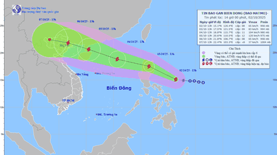
Path of storm MATMO on the morning of October 2
According to the National Center for Hydro-Meteorological Forecasting, at 7:00 a.m., the eye of the storm was located at about 14.9 degrees North latitude, 127.8 degrees East longitude, in the sea east of the Philippines. The strongest wind near the eye of the storm was level 8 (62-74 km/h), gusting to level 10. Moving west-northwest at a speed of 15-20 km/h.
At 7:00 a.m. on October 4, the storm continued to move west-northwest at a speed of about 25 km/h, entering the East Sea and likely to strengthen. The center of the storm was at about 18.6 degrees North latitude, 117.0 degrees East longitude, in the sea east of the North East Sea, about 550 km east-northeast of the Hoang Sa archipelago. Strong winds of level 10, gusts of level 12. The danger zone is from latitude 16.0 degrees North to 21.0 degrees North, east of longitude 115.0 degrees East. The disaster risk level in the sea east of the North East Sea is level 3.
As of 7:00 a.m. on October 5, the storm continued to move west-northwest at a speed of about 25 km/h and was likely to strengthen. The center of the storm was located at about 20.1 degrees North latitude, 111.6 degrees East longitude, in the northwest sea area of the North East Sea, about 70 km northeast of Hainan Island (China). The wind speed is level 12, gusting to level 15. The danger zone is from latitude 17.0 degrees North to 22.0 degrees North; longitude from 110.0 degrees East to 119.0 degrees East. The disaster risk level in the northern sea area of the North East Sea is level 3.
From the next 48 to 72 hours, the storm moves in the west-northwest direction, traveling 15-20 km per hour.
The National Center for Hydro-Meteorological Forecasting forecasts the impact of the storm:
Regarding strong winds and big waves at sea: From the afternoon of October 3, the sea area east of the North East Sea will have winds gradually increasing to level 6-7; then increasing to level 8, the area near the storm center will have strong winds of level 9-10, gusting to level 12, waves 4-6 m high. The sea is very rough.
Warning: During October 4-5, the North East Sea area (including Hoang Sa special zone) is likely to be affected by strong winds of level 11-12, gusting to level 15.
Vessels operating in the above mentioned dangerous areas are susceptible to the impact of storms, whirlwinds, strong winds and large waves.
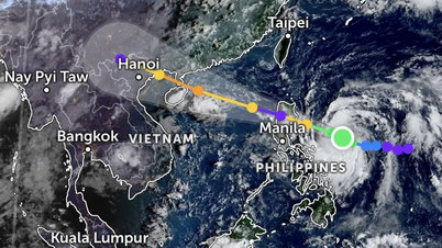
With storm MATMO, the models are quite consistent in predicting the storm's path to pass through southern China and then approach northern Vietnam around October 6, possibly in the Quang Ninh province area.
Due to the storm's influence, it is forecasted that the North will have widespread rain, and Hanoi is also likely to have heavy rain from October 6.
Thu Cuc
Source: https://baochinhphu.vn/bien-dong-sap-don-bao-so-11-du-bao-anh-huong-den-dat-lien-ngay-6-102251002084706796.htm

![[Photo] Binh Trieu 1 Bridge has been completed, raised by 1.1m, and will open to traffic at the end of November.](https://vphoto.vietnam.vn/thumb/1200x675/vietnam/resource/IMAGE/2025/10/2/a6549e2a3b5848a1ba76a1ded6141fae)


Comment (0)