
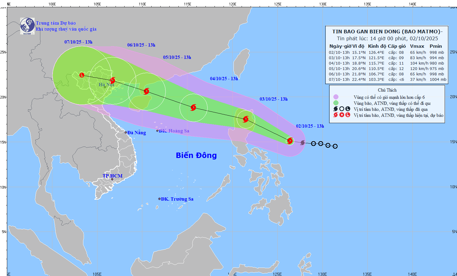
According to the National Center for Hydro-Meteorological Forecasting, at 1 p.m., the eye of the storm was located at about 15.1 degrees North latitude; 126.4 degrees East longitude, in the sea east of the Philippines. The strongest wind near the eye of the storm was level 8 (62 - 74 km/h), gusting to level 10. Moving in the West Northwest direction, speed about 25 km/h.
Forecast, by 13:00 on October 3, the storm will move in the West Northwest direction, speed of about 25 km/h and is likely to strengthen, storm location at 17.5N-121.5E; on the mainland north of Luzon Island (Philippines), storm intensity is level 9, gust level 11, dangerous area is latitude 16.00N-19.50N; east of longitude 118.50E, natural disaster risk level 3, affected area is the sea east of the North East Sea.
At 1:00 p.m. on October 4, the storm moved in the West-Northwest direction, at a speed of 25-30 km/h, entered the East Sea and was likely to strengthen, the storm's location was at 18.8N - 115.7E; in the sea area east of the North East Sea, about 430 km northeast of Hoang Sa special zone, the storm intensity was level 10-11, gust level 13, the dangerous area was latitude 16.50N - 21.00N; east of longitude 113.50E, natural disaster risk level 3, the affected area was the sea area north of the North East Sea.
At about 1:00 p.m. on October 5, the storm moved in the West Northwest direction, at a speed of about 25 km/h and was likely to strengthen further. The storm was located at 20.6N - 110.5E; on the southern coastal area of Leizhou Peninsula (China), the storm intensity was level 12, gusting to level 15, the dangerous area was the area north of latitude 17.50N; longitude 108.5E - 118.00E, the natural disaster risk level was level 3, the affected area was the northern sea area of the North East Sea and the western sea area of the Northern Gulf of Tonkin.
From the next 72 to 120 hours, the storm moves in the West Northwest direction, traveling 15 - 20 km per hour, the storm's intensity gradually decreases.
From noon and afternoon of October 3, the eastern sea area of the North East Sea will have winds gradually increasing to level 6 - 7; then increasing to level 8 - 9, the area near the storm's center will have strong winds of level 10 - 11, gusts of level 12, waves 4 - 6m high. The sea will be rough. Warning, between October 4 - 5, the North East Sea area is likely to be affected by strong winds of level 11 - 12, gusts of level 15.
Vessels operating in the above mentioned dangerous areas are susceptible to the impact of storms, whirlwinds, strong winds and large waves.
Source: https://baotintuc.vn/xa-hoi/bao-matmo-giat-cap-10-tiep-tuc-manh-them-huong-vao-bien-dong-20251002143752308.htm


![[Photo] Binh Trieu 1 Bridge has been completed, raised by 1.1m, and will open to traffic at the end of November.](https://vphoto.vietnam.vn/thumb/1200x675/vietnam/resource/IMAGE/2025/10/2/a6549e2a3b5848a1ba76a1ded6141fae)


Comment (0)