

On the evening of August 23, Deputy Minister of Agriculture and Environment Le Cong Thanh chaired an urgent meeting with units in the meteorological - hydrological, natural disaster prevention and control sectors and authorities of affected localities to deploy forecasting and response work for this storm.

According to Mr. Hoang Duc Cuong, Deputy Director of the Department of Hydrometeorology (Ministry of Agriculture and Environment), there are currently no signs that storm No. 5 is weakening. “The storm is in the strong development stage and will reach its strongest intensity when approaching the shore. If it moves slowly, the storm will have enough time to accumulate more energy to increase its strength. On the contrary, if it moves quickly, the accumulation time will decrease,” Mr. Cuong predicted.
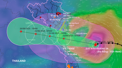
Update information as of 10 p.m. on August 23: The center of storm No. 5 is at coordinates of about 17.7 degrees North latitude - 113.2 degrees East longitude, only about 165km northeast of Hoang Sa special zone. The storm remains at level 10-11 and gusts at level 12-13 as the warning bulletin at 8 p.m. on August 23 (two levels stronger than the morning of August 23). Source: National Center for Hydro-Meteorological Forecasting
The risk of damage is very high.
Representatives of hydrometeorological stations in the Central region also reported on specific risks in localities.
In Ha Tinh province, rice fields that are about to be harvested and many fruit orchards are at risk of serious damage if winds reach level 10 or higher. The province has banned the sea from 5 p.m. on August 23 and is releasing water from reservoirs to prepare for flooding.
In Nghe An province, many reservoirs are full after previous heavy rains, at risk of overflowing and affecting newly planted rice areas. Quang Tri has also banned sea travel and urgently implemented plans to ensure safety for embankment and dam projects under construction.

Mr. Pham Duc Luan, Director of the Department of Dyke Management and Natural Disaster Prevention (Ministry of Agriculture and Environment) warned that storm No. 5 with its strong intensity could cause great damage to boats, houses, structures and trees.

Leaders of the Department of Dyke Management and Natural Disaster Prevention reminded localities to be especially cautious about post-storm circulation, especially in the Western Nghe An and Huong Son (Ha Tinh) areas, where the risk of prolonged flooding is very high.
Forecasts must be detailed and sent to each specific unit.
Deputy Minister of Agriculture and Environment Le Cong Thanh assessed that storm No. 5 appeared at a time when the whole country was preparing to celebrate National Day on September 2. Therefore, forecasting and warning work must be accurate and timely.
Mr. Le Cong Thanh directed the Department of Meteorology and Hydrology to make full use of the satellite system, weather radar in the region and international data, combining domestic monitoring data to closely monitor all developments of the storm.

The Deputy Minister of Agriculture and Environment requested local meteorological stations to regularly provide clear warning information, specifying the impact level of each wind level so that people can proactively respond.
For highway construction sites, the Ministry of Agriculture and Environment requires increased safety measures for workers and construction sites in conditions of heavy rain and strong winds.
Source: https://www.sggp.org.vn/bo-nong-nghiep-va-moi-truong-hop-khan-trong-dem-ung-pho-bao-so-5-post809865.html


![[Photo] The ceremonial artillery is ready to "fire" for the second parade rehearsal at My Dinh National Stadium.](https://vphoto.vietnam.vn/thumb/1200x675/vietnam/resource/IMAGE/2025/8/24/883ec3bbdf6d4fba83aee5c950955c7c)
![[Photo] Impressive image of 31 planes taking flight in the sky of Hanoi during their first joint training](https://vphoto.vietnam.vn/thumb/1200x675/vietnam/resource/IMAGE/2025/8/24/2f52b7105aa4469e9bdad9c60008c2a0)


Comment (0)