

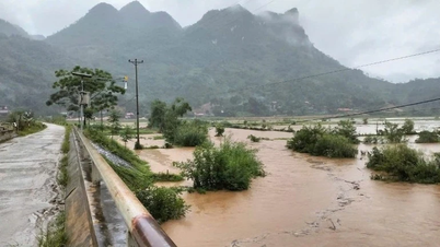
Currently, the downstream water level on the main rivers of the Northern river system is changing slowly and is below alert level 1.
Warning: From tonight (September 9) to September 11, there is a possibility of a flood occurring in the upper reaches of Thao, Lo, Thai Binh rivers and small rivers in the Northern region, with flood levels rising from 3-6m in the upper reaches of rivers.
During this flood, the peak water level on small rivers, upstream of Thao River, Lo River and Thai Binh River is likely to reach alert level 1 to alert level 2, some places above alert level 2, downstream of Thao River and Thai Binh River at alert level 1, downstream of Lo River below alert level 1.
The meteorological agency warned of a high risk of flooding in low-lying areas along rivers, flash floods and landslides on steep slopes in mountainous areas of the North.
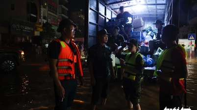
Flash flood and landslide warnings due to heavy rain or water flow in northern mountainous provinces
According to the National Center for Hydro-Meteorological Forecasting, in the past 8 hours (from 0:00 to 8:00 on September 9), the northern mountainous provinces have had moderate rain, heavy rain, and some places have had very heavy rain such as Lang Mo 104.8mm (Lai Chau); Song Da 83mm (Dien Bien); Nam Pam 62.2mm (Son La); Tan Tien 101.6mm (Lao Cai); Thang Tin 115.8mm (Tuyen Quang); Cong Bang 132mm (Thai Nguyen); An Lai 119.6mm ( Cao Bang ); Tan Minh 97mm (Lang Son); Chuc Bai Son 108.6mm (Quang Ninh);...
Soil moisture models show that some areas in the above provinces are close to saturation (over 85%) or have reached saturation.
It is forecasted that in the next 3-6 hours, the above provinces will continue to have rain with common accumulated rainfall as follows: Dien Bien , Lai Chau, Son La, Lao Cai and Tuyen Quang from 30-70mm, some places over 150mm; Quang Ninh, Lang Son, Cao Bang and Thai Nguyen from 20-50mm, some places over 90mm.
The meteorological agency warned that heavy rain could cause flash floods on small rivers and streams, and landslides on steep slopes in many communes and wards.
Flash floods and landslides can have very negative impacts on the environment, threaten people's lives; cause local traffic congestion, affect the movement of vehicles; destroy civil and economic works, causing damage to production and socio-economic activities.
The meteorological agency recommends that local authorities pay attention to reviewing bottlenecks and vulnerable locations in the area to take preventive measures and respond promptly to possible situations.
Source: https://nhandan.vn/cac-song-o-khu-vuc-bac-bo-co-kha-nang-xuat-hien-mot-dot-lu-post906842.html

![[Photo] Prime Minister Pham Minh Chinh chairs the Conference to deploy the National Target Program on Drug Prevention and Control until 2030](https://vphoto.vietnam.vn/thumb/1200x675/vietnam/resource/IMAGE/2025/10/09/1759990393779_dsc-0495-jpg.webp)

![[Photo] Impressions of the Can Gio Whale Festival](https://vphoto.vietnam.vn/thumb/1200x675/vietnam/resource/IMAGE/2025/10/09/1759984089762_image12334-5642-jpg.webp)


![[Infographic] World Cultural Festival in Hanoi - connecting the colors of five continents in the heart of the capital](https://vphoto.vietnam.vn/thumb/402x226/vietnam/resource/IMAGE/2025/10/09/1759995324398_image.jpeg)


Comment (0)