

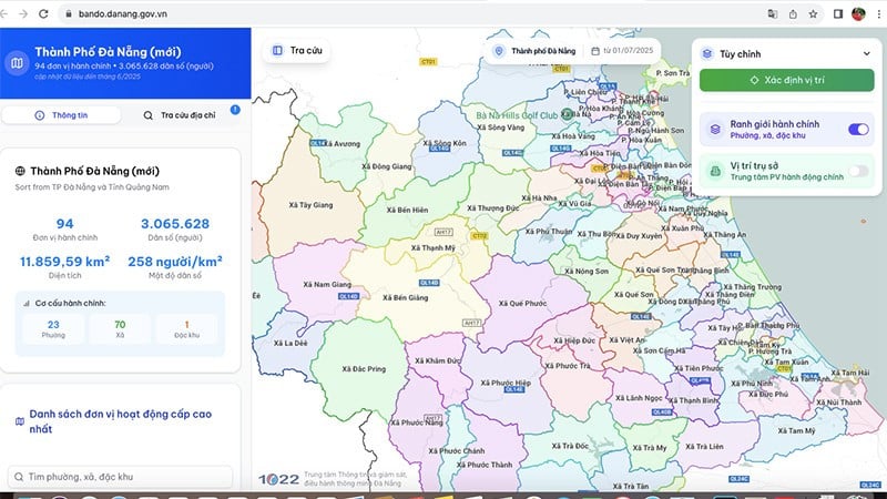
Accordingly, to access digital maps, people can use two official addresses: https://bando.danang.gov.vn or https://danangmoi.1022.vn.
These are two official portals that are regularly updated, integrate intuitive interfaces and are easy to use on both computers and mobile devices.
The digital map fully displays administrative boundaries and addresses of the Public Administration Service Centers of wards and communes on the map, helping people easily identify their residential areas or search for related information.

The map also shows the new names of 94 wards, communes and special zones, and the arrangement from previous administrative units, area, population and other relevant information.
The map system also integrates smart utilities such as: headquarters search, directions using Google Maps, supporting users to quickly determine travel routes and access public administrative agencies in the most convenient and effective way.
In addition, the Department of Science and Technology is also actively coordinating with the map service provider (Google Maps) to change the location of the headquarters of communes, wards, and special zones of Da Nang city (new) on Google's map platform.

This is to ensure that everyone, whether local or outside, can easily search, navigate and access new locations accurately and conveniently on applications/devices using Google maps.
At the same time, citizens can contribute ideas to improve the system via Call Center: (0236) 1022 or Email: gopy@danang.gov.vn.
Feedback and suggestions from citizens will be an important foundation for the city to continue adjusting, upgrading and operating the digital map system effectively, close to practical needs.
Source: https://nhandan.vn/da-nang-trien-khai-ban-do-so-phuong-xa-dac-khu-moi-post891227.html

![[Photo] People eagerly lined up to receive special publications of Nhan Dan Newspaper](https://vphoto.vietnam.vn/thumb/1200x675/vietnam/resource/IMAGE/2025/8/30/53437c4c70834dacab351b96e943ec5c)


![[Photo] People eagerly lined up to receive special publications of Nhan Dan Newspaper](https://vphoto.vietnam.vn/thumb/402x226/vietnam/resource/IMAGE/2025/8/30/53437c4c70834dacab351b96e943ec5c)


Comment (0)