


Deputy Prime Minister Tran Hong Ha chaired a meeting to prepare for response to the tropical depression that could strengthen into storm No. 5 (Kajiki) when entering the East Sea - Photo: VGP/Minh Khoi
Deputy Prime Minister Tran Hong Ha emphasized that storm No. 5 formed quickly from a tropical depression (TLD), has a wide circulation, and is forecast to be complex, requiring ministries, sectors, and localities to be highly focused and absolutely not to make any mistakes, especially at a time when the whole country is looking forward to celebrating the 80th anniversary of National Day, September 2.
Hydrometeorological units must increase the frequency of detailed forecasts on the developments, scope, and level of impact of storm No. 5 in the coming days, especially for Hanoi and major cities, "ensuring accuracy, not being subjective, not being passive".
According to the Deputy Prime Minister, since the Law on Civil Defense came into effect, the organizational structure at the central and local levels has been basically stable. However, the implementation of the two-level government model still has issues in management and direction that need to be further improved.
In recent times, storm response has seen many positive changes, but post-storm impacts such as heavy rains, flash floods, and landslides have still caused heavy damage to lives and property. The “4 on-site” principle has not been implemented evenly in the plains, coastal areas, and mountainous areas; communication and connection at the grassroots level are still inadequate. “We need to frankly acknowledge and share experiences among localities, thereby drawing lessons and perfecting the response system from the central to local levels,” the Deputy Prime Minister emphasized.
The Ministry of National Defense , as the standing agency of the National Civil Defense Steering Committee, needs to clarify the management mechanism and divide responsibilities among levels. “When the Central Government is needed, the Central Government will take action, while the remaining ministries, branches and localities must proactively handle the situation. The grassroots level is currently facing many difficulties and needs more timely support,” said the Deputy Prime Minister, while also asking Nghe An and Thanh Hoa, the localities that have just fought against storm No. 4, to share their experiences and clarify what has been done and what has not been done to propose that the Government, ministries and branches provide earlier support.
“The principle is not to be passive or subjective, but also not to make the situation more serious. After each response, we need to draw lessons to do better for the following storms,” said the Deputy Prime Minister.
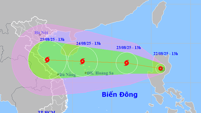
Storm No. 5 moves fast, intensity increases continuously
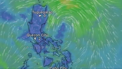
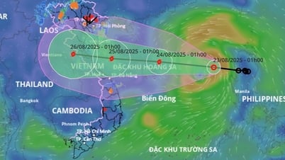
According to the report of the Department of Hydrometeorology (Ministry of Agriculture and Environment), on the morning of August 22, a low pressure area in the eastern part of Luzon Island (Philippines) has strengthened into a tropical depression, level 6, gust level 8, moving northwest at a speed of 10-15km/h. Around the night of August 22, the tropical depression will move into the East Sea, likely to strengthen into a storm, the 11th storm in the northwest Pacific region and the 5th storm in the East Sea (international name is Kajiki).
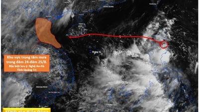
When the storm moves into the East Sea, storm No. 5 moves quickly, at a speed of about 20 km/h. Around August 24, when the storm moves to the Hoang Sa archipelago, its intensity can reach level 10-11, gusting to level 13-14, and it can even get stronger when moving into the Gulf of Tonkin. It is forecasted that storm No. 5 will maintain its intensity at level 11-12, gusting to level 16 when it approaches the Vietnamese mainland on August 25, directly affecting the central provinces from Thanh Hoa to Hue.


Leaders of ministries, branches and localities report - Photo: VGP/Minh Khoi
Mr. Hoang Duc Cuong, Deputy Director of the Department of Hydrometeorology, said that the characteristics of storm No. 5 are fast movement, wide circulation, short activity cycle (more than 3 days compared to the average of about 6-7 days), so the intensity increases continuously until it makes landfall. The area of strong winds of level 10 has a radius of about 170 km.
Due to the influence of the storm circulation in the northern and central areas of the East Sea (including Hoang Sa special zone), from tomorrow (August 23), there will be strong winds of level 6-7, then increasing to level 8-9. From August 24, the strong winds will increase to level 10-11, gusting to level 13-15. Waves from 4-7 m high, very rough seas with thunderstorms, whirlwinds and heavy rain can sink all ships, including large tonnage ships.
The island districts of Ly Son, Cu Lao Cham, and Con Co are likely to be greatly affected by strong winds caused by storm No. 5.
From the night of August 24, coastal waters from Thanh Hoa to Hue will have strong winds of level 7-8, then gradually increasing to level 9-10, near the storm center level 11-12, gusting to level 14-15, waves 4-6 m high. Boat mooring areas and aquaculture cages are at risk of being greatly affected by strong winds and big waves, especially the area from southern Thanh Hoa to Quang Tri.
When the storm is still 300-400 km from the mainland, coastal areas from Quang Ninh to Hue and Da Nang cities should pay attention to thunderstorms in the front part of the storm. Hydro-meteorological forecasting units will increase monitoring and warning of thunderstorms and tornadoes every hour.
According to the current impact scenario, the storm's impact circulation is very wide, affecting the northern and north central coasts. The coastal area from Nghe An to Quang Tri will be the main area affected by the storm's circulation, with the possibility of strong coastal winds of level 10-11, gusting to level 13-14.
From the night of August 24 to the end of August 27, in the area from Thanh Hoa to Hue City, there will be a period of heavy to very heavy rain, with common rainfall from 150-300 mm, some places over 600 mm, it is necessary to pay attention to heavy rain with rainfall over 200 mm/3 hours.
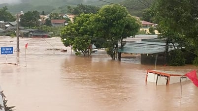
This rain is not only affecting the coastal areas but also extending to the western provinces of the North Central region. There is a risk of flash floods, landslides and flooding in low-lying areas, riverbanks, and urban areas in the provinces in the above regions. Localities need to proactively deploy flood prevention plans, check residents in dangerous areas, and ensure the safety of reservoirs and flood prevention works.
On rivers from Thanh Hoa to Quang Tri, there was a flood, the upstream reached alert level II, alert level III; downstream of main rivers reached alert level I, alert level II, Quang Binh, Quang Tri had places above alert level II.
Urgently prepare to respond to heavy rain
Deputy Minister of Agriculture and Environment Nguyen Hoang Hiep said that, unlike current regulations, warnings for tropical depressions are issued 24 hours in advance and for storms are issued 48 hours in advance, this time the Ministry has been flexible and earlier to avoid being passive. The Ministry has been proactive in responding to storm No. 5, early and from afar. Two days ago (August 20), the National Center for Hydro-Meteorological Forecasting issued a long-distance warning; yesterday (August 21), it officially issued a tropical depression warning, and this morning (August 22), the Ministry held an urgent meeting, agreed on assessments, directed localities and issued urgent warnings.
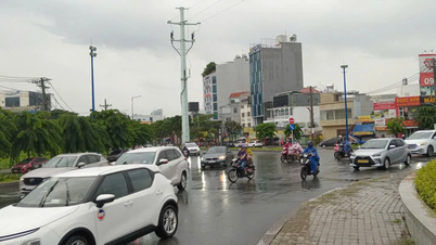
According to forecasts, storm No. 5 is forming right in the East Sea, moving straight, fast, with heavy rain although the wind is not too strong. Worryingly, the storm is likely to affect Thanh Hoa to Hue City right on the weekend, coinciding with the time before the new school year starts and activities to celebrate the 80th anniversary of the August Revolution and National Day on September 2.
Regarding agricultural production, the area from Thanh Hoa to Hue currently has more than 200,000 hectares of rice in the earing and flowering stage. If the wind is strong, flooding will cause great damage, with the risk of crop failure. The Ministry of Agriculture and Environment has directed localities to proactively drain buffer water and dry the fields to reduce damage. In addition, fruit trees and industrial trees such as rubber are also at risk of falling when the storm makes landfall.
Deputy Minister Nguyen Hoang Hiep emphasized that the biggest concern is rain. Irrigation and hydropower reservoirs in the area are holding up to 80% of their capacity. If there is heavy rain, the risk of reservoir safety and a recurrence of the incident at Ban Ve Hydropower Plant is very high. The Ministry of Agriculture and Environment has asked the Ministry of Industry and Trade to resolutely direct management units, especially small hydropower plants, to calculate proactive flood discharge plans.
The risk of flooding is also particularly high, especially in the downstream areas of the lakes. In addition, heavy rainfall from Laos flowing down the Ma and Ca rivers further increases the risk. Currently, the National Center for Hydro-Meteorological Forecasting is using satellite data and artificial intelligence to forecast rainfall from Laos.
The Ministry of Agriculture and Environment recommends that localities of Thanh Hoa, Nghe An, Ha Tinh, Quang Binh, Quang Tri, and Hue proactively plan early migration, learning from experiences from Dien Bien, Lai Chau, and Con Cuong (Nghe An), to avoid separation and passivity.
Lieutenant General Doan Thai Duc, Director of the Department of Search and Rescue (Ministry of National Defense) said that the Ministry of National Defense has sent a telegram to agencies and military units in the area affected by storm No. 5, from the sea of Quang Ninh to Khanh Hoa, to be ready to mobilize people and vehicles. The focus of response is in the areas of Military Region 4 and Military Region 5; other units are on duty on site and ready to mobilize when ordered. Hotline 112 was activated from August 15 to receive requests for assistance and search and rescue nationwide.
Leaders of Thanh Hoa and Nghe An provinces said that both localities have just experienced major storms, including storm No. 4, which caused a lot of damage. The terrain of these provinces is both mountainous and plain and coastal, so natural disasters are very complicated: Mountainous areas often have flash floods and landslides; plain and coastal areas are directly affected by storm circulation.
Localities have implemented the “four on-site” motto, mobilizing maximum local forces to respond, and initially demonstrated effectiveness. However, reality shows that the direction and operation work still faces many difficulties and shortcomings. The communication system at the grassroots level is sometimes interrupted; the capacity, means, and equipment for rescue and relief at the commune and district levels are still limited; the infrastructure is not yet synchronized, making mobilization and rescue difficult.
The leaders of the two provinces proposed that the Government and the National Steering Committee soon have a mechanism to support resources and equipment, as well as improve the capacity to forecast hydrology, rain, floods and coordinate to help localities be more proactive in preventing, combating and overcoming the consequences of natural disasters, minimizing human and property damage in upcoming storms.

The Deputy Prime Minister emphasized that no matter how hard we try, forecasting is just forecasting, so agencies must closely follow actual developments and continuously update for prevention - Photo: VGP/Minh Khoi
Forecasting work must always be proactive, prevention is the key.
Concluding the meeting, the Deputy Prime Minister emphasized that no matter how hard we try, forecasting is just forecasting, so agencies must closely follow actual developments and continuously update for prevention. Good prevention will reduce damage, while subjectivity and lack of initiative will have huge and unpredictable consequences. “After each storm, each natural disaster, agencies, ministries and localities must learn from experience and improve further. They must not be subjective, they must be proactive and have a scientific and rigorous plan.”
In recent times, meteorological and hydrological agencies have forecasted storm trends and storm levels quite accurately, and have cooperated well with international centers. However, rain and hydrological forecasting still has many limitations that need to be overcome. The Ministry of Agriculture and Environment must direct that after each storm, there be a survey and re-evaluation of forecast results, draw out shortcomings, and propose solutions for improvement, especially regarding rain and hydrology.
The Deputy Prime Minister requested that forecasting agencies take into account rains from upstream Laos and coordinate internationally to obtain accurate and timely information. “Forecasting must go hand in hand with “sharp weapons”, that is, tools and models must be effective enough. Although artificial intelligence and models have been applied, if the cause of errors is not understood and cannot be overcome, it is still a limitation,” the Deputy Prime Minister said, clarifying that forecasting work needs to provide timely information on the developments of storm No. 5 to the Prime Minister to issue response telegrams, and regularly update localities, especially places where important political events take place such as Hanoi. In addition, there must be an assessment of the scope of influence at sea, on land, tides, waves, and the risk of coastal surges; forecasting before, during, and after the storm, especially the post-storm circulation.
Response operations must have specific scenarios and clear hierarchy.
The Deputy Prime Minister requested ministries, sectors and localities to urgently review all reservoirs and dams for irrigation and hydropower. The Ministry of Industry and Trade is responsible for regulating reservoirs and dams under its management, and coordinating with the Ministry of Agriculture and Environment to effectively operate the inter-reservoir system.
Provinces and cities must develop plans and scenarios to respond to storm No. 5 specifically for each region: Delta, coastal, mountainous. Responsibilities must be clearly assigned to the Provincial Military Command, Department of Agriculture and Environment, Department of Construction, Department of Industry and Trade, Health, district and commune authorities. The evacuation plan must be specific: in which cases will people be evacuated, which forces will participate, where will people be moved.
The Deputy Prime Minister emphasized the role of local forces, especially in high-risk areas that are easily isolated. Military Region 4, Military Region 5 and the provincial Military Commands must coordinate with localities, deploy forces promptly, and support the “four on-sites”.
According to the Deputy Prime Minister, the current weakness is that when natural disasters occur, there are often power outages and information loss. He requested the Standing Office of the National Civil Defense Steering Committee and related units, along with VNPT, Viettel, the army and the police, to have a backup plan from now on: Arrange generators, satellite equipment, maintain connections to communes, villages and hamlets in mountainous areas...
The Deputy Prime Minister emphasized that in localities, the “four on-site” motto is not only about people and means, but also about having adequate reserves: food, medicine, drinking water, essential supplies, electricity, and communications. In particular, it is necessary to prepare for each residential area in remote areas, where a commune is sometimes larger than a plain district, and is easily isolated when storms and floods occur.
The Deputy Prime Minister requested the development of a clear operational scenario when responding to the storm. First of all, the locality is fully responsible; next is the relevant ministry; and finally the Central Steering Committee. Localities have the right to use the “power of the Prime Minister, Deputy Prime Minister, and Minister” to mobilize forces when necessary. Only when their capacity is exceeded will they request support from the Central Government.
“Currently, the response is still passive and simple. Sometimes the Central Government gives instructions, leading to a lack of focus. We need to specialize, increase scientific knowledge, and rely on clear decentralization to respond effectively and in the long term,” the Deputy Prime Minister pointed out.
In addition to immediate response work, the Ministry of Agriculture and Environment and localities should pay attention to agricultural production during the storm season: aquaculture, rice, industrial crops, fruit trees, etc. Local departments and branches must proactively advise leaders, not wait for instructions from the Ministry.
Provinces and cities focus on planning, building safe residential areas, eliminating temporary housing, and relocating residents in high-risk areas. This is a long-term task, contributing to improving the ability to adapt to climate change and respond to extreme natural disasters.
Minh Khoi
Source: https://baochinhphu.vn/du-bao-som-chinh-xac-lien-tuc-cap-nhat-kich-ban-ung-pho-bao-so-5-102250822185852441.htm

![[Photo] Prime Minister Pham Minh Chinh chairs the conference to review the 2024-2025 school year and deploy tasks for the 2025-2026 school year.](https://vphoto.vietnam.vn/thumb/1200x675/vietnam/resource/IMAGE/2025/8/22/2ca5ed79ce6a46a1ac7706a42cefafae)
![[Photo] President Luong Cuong attends special political-artistic television show "Golden Opportunity"](https://vphoto.vietnam.vn/thumb/1200x675/vietnam/resource/IMAGE/2025/8/22/44ca13c28fa7476796f9aa3618ff74c4)
![[Photo] President Luong Cuong receives delegation of the Youth Committee of the Liberal Democratic Party of Japan](https://vphoto.vietnam.vn/thumb/1200x675/vietnam/resource/IMAGE/2025/8/22/2632d7f5cf4f4a8e90ce5f5e1989194a)


Comment (0)