
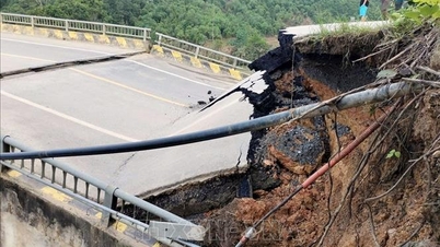
Rainfall recorded from 7:00 p.m. on August 22 to 0:00 a.m. on August 23 was over 50mm in some places, typically at Cao Bo 2 station (Tuyen Quang) 84.4mm; Pha Khinh station (Son La) 84.4mm; Pu Nhung station ( Dien Bien ) 59.0mm.
In the next 24 hours, the mountainous areas of the North are forecast to have scattered showers and thunderstorms, with rainfall ranging from 10 to 30 mm, with local heavy rain exceeding 80 mm, concentrated in the early morning, late afternoon and night. The Central Highlands and the South are also forecast to have scattered showers and thunderstorms, with rainfall ranging from 10 to 30 mm, with local heavy rain exceeding 60 mm. During thunderstorms, there is a possibility of tornadoes, lightning, hail, and strong gusts of wind; there is a risk of flash floods on small rivers and streams and landslides in mountainous areas.

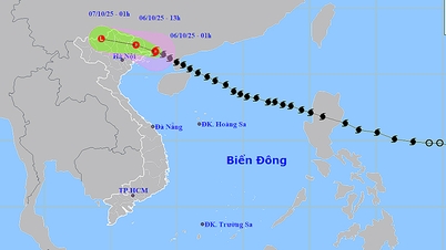
On the same day, the tropical depression entered the eastern sea area of the North East Sea. At 1:00 a.m. on August 23, the center of the tropical depression was at about 17.1 degrees North latitude; 118.2 degrees East longitude, about 730 km east of the Hoang Sa archipelago. The strongest wind near the center of the tropical depression was level 7 (50 - 61 km/h), gusting to level 9; moving in the West Northwest direction at a speed of about 25 km/h.
In the next 24 hours, the North East Sea area, including the Hoang Sa sea area, will have strong winds of level 6 - 7, then increasing to level 8; the area near the storm's center will have strong winds of level 9 - 10, gusting to level 12. The sea will be very rough, with waves 3 - 5m high, and 4 - 6m near the center. The Central East Sea area, the sea area from Khanh Hoa to Lam Dong, will have strong southwest winds of level 5 during the day, sometimes level 6; at night, it will strengthen to level 6, gusting to level 7 - 8; the sea waves will be 2 - 3m high, rough sea.
In addition, the North East Sea area (including Hoang Sa sea area) has storms; the Central and South East Sea area (including Truong Sa), the sea area from Gia Lai to Ca Mau, from Ca Mau to An Giang and the Gulf of Thailand have scattered showers and thunderstorms, with the possibility of tornadoes, strong gusts of wind of level 6 - 7 and waves over 2m high.
Authorities recommend that all vessels operating in the area closely monitor the development of the tropical depression, proactively take preventive measures, and ensure the safety of people and vehicles.
Weather forecast for regions across the country:
Hanoi capital is cloudy, sunny during the day, showers and thunderstorms in some places in the evening and at night. Light wind, from early tomorrow morning northeast to north wind 2 - 3. During thunderstorms there is a possibility of tornadoes, lightning and strong gusts of wind. Lowest temperature 25 - 27 degrees Celsius. Highest temperature 32 - 34 degrees Celsius.
The Northwestern region is cloudy with scattered showers and thunderstorms, with some places experiencing heavy rain (rain concentrated in the early morning, late afternoon and night). Light wind. During thunderstorms, there is a possibility of tornadoes, lightning, hail and strong gusts of wind. The lowest temperature is 23 - 26 degrees Celsius, some places below 23 degrees Celsius. The highest temperature is 30 - 33 degrees Celsius, some places above 33 degrees Celsius, especially Lai Chau - Dien Bien 27 - 30 degrees Celsius.
The Northeastern provinces are cloudy with scattered showers and thunderstorms, especially in mountainous areas with scattered showers and thunderstorms, with some places having heavy rain (rain concentrated in the early morning, late afternoon and night). Light wind, from early tomorrow morning, northeast to north wind level 2 - 3. During thunderstorms, there is a possibility of tornadoes, lightning, hail and strong gusts of wind. The lowest temperature is 24 - 27 degrees Celsius, some places below 24 degrees Celsius. The highest temperature is 30 - 33 degrees Celsius, some places above 34 degrees Celsius.
Provinces from Thanh Hoa to Hue will have cloudy weather, sunny days, scattered showers and thunderstorms in the evening, and scattered showers and thunderstorms at night. Light winds. During thunderstorms, there is a possibility of tornadoes, lightning, hail, and strong gusts of wind. Lowest temperature 24 - 27 degrees Celsius. Highest temperature 31 - 34 degrees Celsius, some places above 34 degrees Celsius.
The South Central Coast region is cloudy with scattered showers and thunderstorms, especially in the evening with scattered showers and thunderstorms. Southwest wind level 2 - 3. During thunderstorms, there is a possibility of tornadoes, lightning, hail and strong gusts of wind. The lowest temperature is 23 - 26 degrees Celsius. The highest temperature is 31 - 34 degrees Celsius, some places above 34 degrees Celsius.
The Central Highlands is cloudy with scattered showers and thunderstorms, with scattered showers and thunderstorms in the late afternoon and evening, and locally heavy rain. Southwesterly winds level 2-3. Thunderstorms are likely to produce tornadoes, lightning, hail, and strong gusts of wind. Lowest temperature 20-23 degrees Celsius. Highest temperature 28-31 degrees Celsius.
The South is cloudy with scattered showers and thunderstorms, with scattered showers and thunderstorms in the late afternoon and evening, and locally heavy rain. Southwesterly winds level 2-3. Thunderstorms are likely to produce tornadoes, lightning, hail, and strong gusts. Lowest temperature 23-26 degrees Celsius. Highest temperature 30-33 degrees Celsius, with some places above 33 degrees Celsius.
Ho Chi Minh City is cloudy with scattered showers and thunderstorms, with scattered showers and thunderstorms in the late afternoon and evening, and locally heavy rain. Southwest wind level 2-3. During thunderstorms, there is a possibility of tornadoes, lightning, hail, and strong gusts of wind. Lowest temperature 23-25 degrees Celsius. Highest temperature 32-34 degrees Celsius.
Source: https://www.sggp.org.vn/mua-dong-dien-rong-o-bac-bo-ap-thap-nhiet-doi-di-vao-bien-dong-post809732.html
![[Photo] Closing of the 13th Conference of the 13th Party Central Committee](https://vphoto.vietnam.vn/thumb/1200x675/vietnam/resource/IMAGE/2025/10/08/1759893763535_ndo_br_a3-bnd-2504-jpg.webp)


Comment (0)