
I can't remember how many times I've knelt and embraced that border marker numbered 92. I also can't explain what kind of magic that marker possesses, but every time I see it, I feel a surge of emotion.
Without any forced effort, as if it were natural, I embraced it from the first time I saw it, when the marker was just a concrete structure, dry and square, not much different from a kilometer marker along the highway. Back then, "92" was located in the middle of a dense area of reeds; to get there, you had to push through the reeds, wade through the weeds, and the reed leaves would cut across your face.
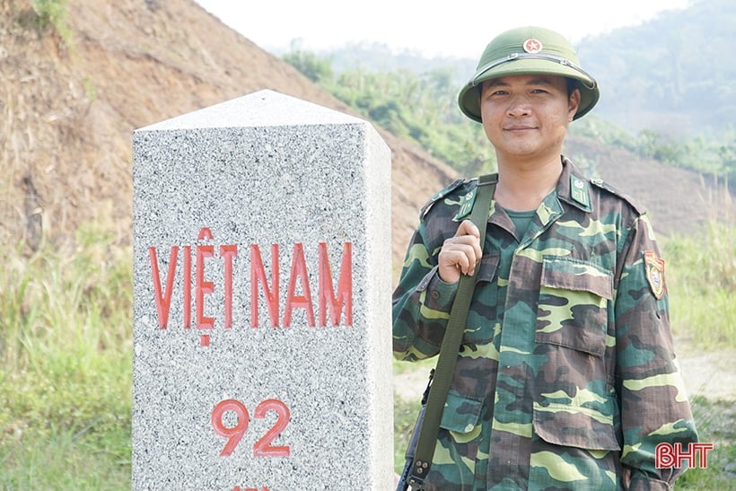
Milestone No. 92 - the point where the Red River enters Vietnamese territory.
I first saw "92" when my border guard friend, riding his Chinese-made Win motorcycle, arrogantly greeted me, then carried me along a trail, pushing through the reeds to the border marker, chuckling: "The A Mú Sung Border Guard Post manages a 27-kilometer border with four border markers, numbered from 90 to 94. This border marker 92 is where the Red River 'enters' Vietnamese territory." I looked up at him. The word "enters" he just used sounded strange, peculiar, and haunting. That border marker, where the Red River "enters" – the first point where the Red River flows into Vietnamese territory – is called Lũng Pô, located in A Mú Sung commune, Bát Xát district, Lào Cai province. It is the northernmost point of Bát Xát district, under the jurisdiction of the A Mú Sung Border Guard Post.
Wandering around and chatting with the locals, I learned that Lung Po – known in ancient Vietnamese as Long Bo – is a stream that was originally a small tributary of the Thao River, originating from the mountain range on the Vietnam-China border in the northern part of Nam Xe commune, Phong Tho district, Lai Chau province. The stream flows southeast through Nam Xe commune. Upon reaching Y Ty commune, Bat Xat district, Lao Cai province, it changes direction to northeast and flows to Lung Po village, A Mu Sung commune. Locally, it means "Big Dragon Hill," or "Dragon's Head," as the stream meanders around a hilltop resembling a dragon's head before emptying into the Lung Po village junction.
At that time, it met the flow of the Yuanjiang River (as it is called in China), which flows into Vietnam and is known as the Red River, dividing the two countries at milestone 92. That is also the first point where the Red River "enters" Vietnamese territory, as my border guard friend introduced. From here, the Red River flows tirelessly through Vietnamese land, passing through the midland with its palm forests and tea hills, then carrying alluvial deposits to build the fertile delta, with its brilliant Red River civilization intertwined with the ups and downs of the nation's history.
And then, unlike Lung Cu - Ha Giang, the northernmost point, or A Pa Chai - Dien Bien , or the place where the pen strokes traced the S-shape of Vietnam's map in Tra Co - Mong Cai - Quang Ninh, Lung Po, with its milestone number 92, leaves a deep mark in the hearts of every Vietnamese person. It is not only a landmark where the Cai River - the Red River - flows into Vietnam, but also the soul and spirit, the place that preserves the silent history of our origins, of the prosperity and sacrifices of countless generations of Vietnamese people on this borderland.
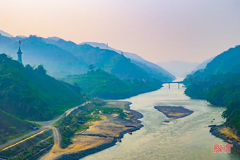
This is where the Red River merges with the Lung Po stream before flowing into Vietnamese territory.
Carrying those resonant sounds within me, I silently climbed to the top of Dragon Hill, gazing down the Red River. The low-lying villages nestled among the lush green rice paddies filled my eyes. The wind carried the scent of the earth and the forest, filling my lungs, and I suddenly felt a pang of emotion. Perhaps the color of the Red River's water where it enters Vietnam, where the river's water takes on two shades of reddish-brown and blue, is an indefinite mark of sacred connection, a defining feature but also a symbol of integration and shared development in this borderland.
Lung Po - a landmark of history
The story begins by the fireplace in the home of old Thào Mí Lở, dating back to the time of the French colonial invasion of Vietnam. Before that, this mountainous forest region was the territory of the Hmong, Dao, and Giáy people living together. The folk song "Giáy low, Hmong high, Dao mid-range" tells of the division of land for each ethnic group to build their houses. They lived peacefully with the forest, the streams, and their own festivals and seasonal celebrations. Only when a strange ethnic group appeared—white skin, blue eyes, prominent noses, and voices like birds that were neither Hmong, Dao, nor Giáy—did the forest and the Lũng Pô stream become disturbed.
Elder Thào Mí Lở took a sip of wine, nodding his head slightly: “The old man from Lũng Pô recounted: ‘In 1886, the merchants guided French warships carrying large, cumbersome guns up the Red River to occupy Lào Cai. Their ships roared along the river, their guns spewing fire into the villages. People died, buffaloes perished, houses burned… The Hmong people, especially those from the Thào clan, along with other clans, the Dao, the Giáy… joined forces to fight back against the merchants and the French.’”
The Lung Po forest and streams, which daily provided them with vegetables, corn, and meat, now joined the people in fighting against land grabbers and bandits. Using flintlock rifles and stone traps, the Mong, Dao, Giay, and Ha Nhi people fought back against the French invaders. In their first battle, the villagers ambushed and annihilated the French troops at Trinh Tuong. That place still has the Tay waterfall today. They were safe for a while, but then the invaders returned. Eight years later, at Lung Po, the people of Lung Po ambushed and routed a French army unit.”
The story of old man Thào Mí Lở is the beginning of the heroic tradition of fighting invaders and defending the border of this historical place. This led to the continuation of the battles fought by countless border guards protecting the sacred borders of the Fatherland throughout history. In particular, this place has become a memorial to the sacrifices of border guards and people of ethnic minorities in the fight against invading forces to protect the Fatherland's border in February 1979.
The story of the sacrifices and losses of soldiers and civilians along the northern border is as endless as the journey up the Red River from Lung Po, the dividing line between Vietnam and China in Bat Xat, Lao Cai, leaving both the speaker and the listener deeply moved. On the memorial plaque at the A Mu Sung Border Guard Post, precisely where the Red River flows into Vietnamese territory, the names of 30 soldiers who died in the border defense battle on February 18, 1979, are still inscribed.
The flickering red incense sticks in the early morning mist at the memorial site of the new outpost resembled red eyes, reminding those who come after of the courageous and resolute spirit of attacking the enemy to the last breath. The inscription on the memorial plaque once again affirms the unwavering sovereignty of the sacred border.
Lung Po - a landmark of pride and love for the homeland.
"Under the golden starlight at the border"
Stone is also a citizen of my country.
As evening falls, mist creeps across the rocky surface.
Like a water reservoir sweating profusely
Both the rocks and the people are majestic..."
The poems of Do Trung Lai not only depict the hardships faced by the border soldiers and civilians in general, and Dong Van in particular, but also express a deep love for the homeland embedded in this land of Lung Po. Lung Po is not only a landmark where the Red River flows into Vietnam, but also a place that preserves the silent history of the border region, a place that commemorates the sacrifices of the border soldiers and civilians who fought and fell to protect the homeland.
To commemorate this, at milestone number 92 at the foot of Dragon Mountain in Lung Po village, on March 26, 2016, the Lung Po flagpole, 41m high, with the main body of the flagpole measuring 31.34m, bearing the symbol of the "Roof of Indochina" of the legendary Phanxipang peak, was started construction on a 2,100 m² site, with the Lao Cai Provincial Youth Union as the investor, and completed on December 16, 2017.
Climbing the 125 spiral steps along the 9.57m length of the flagpole, you will reach the top where the 25m² red flag with a yellow star , symbolizing the 25 ethnic groups living in Lao Cai province, proudly flies in the border breeze.
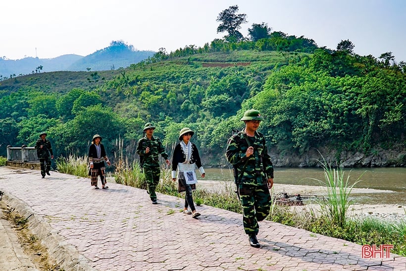
Patrolling and protecting border marker number 92.
The national flagpole at Lung Po once again reminds us of the heroic deeds and unwavering sacrifices of the soldiers and civilians who have kept this borderland peaceful and is a symbol of national pride. From the top of the flagpole, gazing far into the distance at the red hues of the Red River flowing below, and the vast green expanse where the river confluence is dotted with endless fields of corn, bananas, and cassava... the banks evoke a profound resonance in our hearts as we understand that the green and red colors of every inch of land, every branch and blade of grass here are stained with the blood of countless people who bravely defended the land and protected the nation's borders. The flag, fluttering proudly in the sun and wind, affirms that, no matter the cost, the national border will always remain strong.
Now, with the war long over, and the Red River flowing from its confluence into Vietnamese territory still rising with the tide, the sovereignty of the Fatherland is protected by the people's unwavering support. That, too, is a very, very long story. After the war ended, the hardships, suffering, and misery of the people here were as numerous as the leaves in the forest, so many that it's impossible to remember them all.
The area is home to five ethnic groups—Hmong, Dao, Tay, Nung, and Kinh—who share a tradition of slash-and-burn agriculture and forest resource exploitation. When the fighting ended, the lives of these people virtually began from scratch: no water, no roads, no electricity, no schools, no clinics; and then there were the unexploded bombs and mines left over from the war...
All those difficulties were gradually overcome thanks to the skillful, close-knit, and dedicated efforts of the border guards – who spearheaded various movements and encouraged the people to listen and understand – leading the way. Today, many new initiatives and effective economic models have helped the people improve their lives, ensuring they have enough to eat and wear, and ultimately achieving prosperity. Now, electricity, roads, schools, and health stations have reached the Lung Po border marker, and the lives of the people are more prosperous, gradually catching up with the villages in the lowlands.
From Lung Po, the Red River flows majestically downstream. Along its course, the indomitable spirit of the Vietnamese people has been passed down through generations. The Red River continues to flow day and night from Lung Po into the heart of the nation, stretching 517 kilometers and known by 10 different names depending on the local dialect and the culture of the land it flows through.
The section flowing from Lung Po to Viet Tri, where it meets the Lo River, has a very poetic name: Thao River; from Viet Tri, at the confluence of the rivers, towards Hanoi, it is called Nhi Ha (or Nhi Ha according to the local pronunciation). Then, the Red River flows leisurely downstream, creating the entire brilliant Red River civilization with its vast, fertile delta before emptying into the sea at the Ba Lat estuary. Regardless of its name, the river begins at Lung Po, bearing the imprint of Lung Po, of the patriotic tradition at the point where it enters Vietnamese territory, a tradition that has remained unchanged for millennia.
Ly Ta May
Source


Comment (0)