
Latest storm news
According to the National Center for Hydro-Meteorological Forecasting, on September 30, a very strong storm with the international name of Typhoon Krathon is currently active in the sea north of Luzon Island (Philippines).
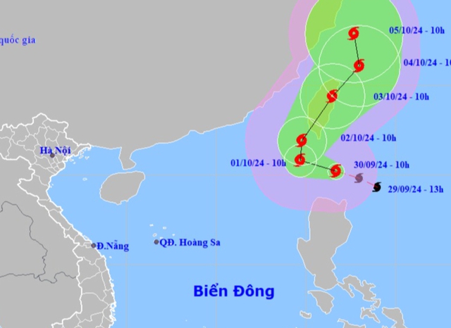
Location and forecast direction of storm Krathon. Source: National Center for Hydro-Meteorological Forecasting
Specifically, according to the latest news from the National Center for Hydro-Meteorological Forecasting, at 1:00 p.m. on September 30, the center of the storm was located at about 20.4 degrees North latitude; 121.3 degrees East longitude, in the sea north of Luzon Island (Philippines). The strongest wind near the center of the storm is level 15 (167-183 km/h), gusting to level 17. Moving in the West Northwest direction, speed 10-15 km/h.
In the next 24 hours, Typhoon Krathon is likely to enter the northeastern sea area of the North East Sea. According to current forecasts, the typhoon is unlikely to affect coastal areas and mainland of our country.
Forecast time | Direction, speed | Location | Intensity | Danger zone | Disaster Risk Level (Affected Area) |
13h/01/10 | West Northwest, about 10km/h, likely to enter the East Sea | 21.0N-119.7E; in the northeastern sea of the North East Sea area | Level 15, jerk above level 17 | North latitude 18.0N; East longitude 116.5E | Level 3: Northeast of the North East Sea area |
13h/02/10 | North, 5-10km/h | 22.2N-119.9E; in the northeastern sea of the North East Sea area | Level 15, jerk above level 17 | North of latitude 18.5N; East of longitude 116.5E | Level 3: Northeast of the North East Sea area |
13h/03/10 | North Northeast, about 15km/h, intensity gradually weakens | 24.6N-122.0E; in the sea northeast of Taiwan Island (China) | Level 10, jerk level 12 | North of latitude 20.0N; East of longitude 117.0E |
From the next 72 to 120 hours, the storm will move mainly in the North Northeast direction, about 5-10km per hour, and its intensity will continue to weaken.
Impact of Typhoon Krathon
At sea:
Northeast sea area of North East Sea (North of latitude 18.0N; East of longitude 116.5E) strong wind level 6-7, from early morning of October 1 strengthening to level 8-9, waves 2.0-4.0m high, then increasing to level 10-12, near the storm center level 13-15, gusting above level 17, waves 7.0-9.0m high; rough sea.
Ships operating in the above mentioned dangerous areas are likely to be affected by storms, whirlwinds, strong winds and large waves.
Cold air is coming, the North is cold below 16 degrees Celsius, very heavy rain
In addition, the cold air mass reported in the North is still moving south.
It is forecasted that around early morning and on October 1, this cold air mass will affect the Northeast region, then affect the North Central region, some places in the Northwest and the Central Central region. The wind will change to the Northeast at level 3 inland, level 4-5 in coastal areas.
During this cold spell, the weather in the North and North Central regions will turn cool; the nights and early mornings will be cold, especially in the mountainous areas of the North. The lowest temperature in the North and Thanh Hoa is generally from 19-22 degrees Celsius, in mountainous areas 17-19 degrees Celsius, in high mountainous areas below 16 degrees Celsius; in Nghe An- Ha Tinh, the lowest temperature is generally from 20-23 degrees Celsius.
During the day and night of September 30, in the Northern region, Thanh Hoa and Nghe An, there will be moderate to heavy rain and scattered thunderstorms, locally very heavy rain with common rainfall of 20-70 mm, locally over 150 mm. During thunderstorms, there is a possibility of tornadoes, lightning, hail and strong gusts of wind.
Source: https://danviet.vn/tin-bao-moi-nhat-mot-con-bao-manh-giat-tren-cap-17-dang-o-gan-bien-dong-co-anh-huong-den-viet-nam-20240930145852236.htm


Comment (0)