
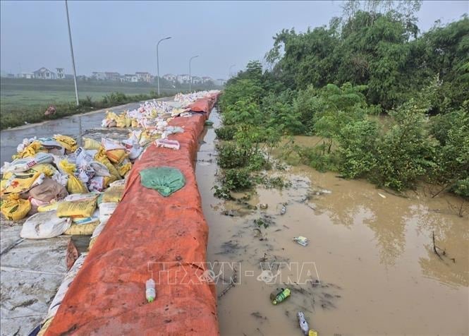
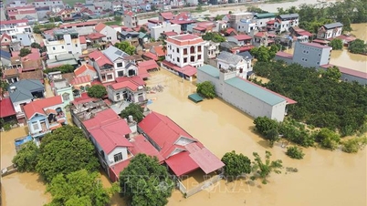
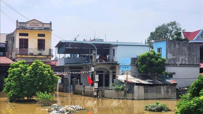
According to the Department of Dyke Management and Natural Disaster Prevention and Control ( Ministry of Agriculture and Environment ), as of 7:00 a.m. on October 12, heavy rain and floods after storm No. 11 caused 59 dike incidents in the provinces and cities of Thai Nguyen, Bac Ninh, and Hanoi.
According to the National Center for Hydro-Meteorological Forecasting, from 10:00 to 21:00 on October 12, flood on Thuong River at Phu Lang Thuong station will drop to alert level 3, flood on Cau River at Dap Cau station will drop to alert level 2.
In the next 12 to 24 hours, flood on Thuong River at Phu Lang Thuong station will continue to decrease and be above alert level 2; flood on Cau River at Dap Cau station will continue to decrease and be above alert level 1.
Flooding in Thai Nguyen, Bac Ninh provinces and Hanoi city is still continuing in riverside communes and wards, low-lying areas and may last from 1 to 2 days; there is a risk of riverbank erosion, river dikes and landslides on slopes in the above areas.
Currently, the flood on Cau River and Thuong River (Bac Ninh) is receding. The water level at 8:00 a.m. on October 12 on Cau River at Dap Cau station was 5.87 m, 0.43 m below alarm level 3; on Thuong River at Phu Lang Thuong station was 6.73 m, 0.43 m above alarm level 3.
At the same time, the water level at the headwaters of the Mekong River continues to fall. In the next 24 hours, the water level on the Tien River at Tan Chau station is forecast to drop to 3.83 m, 0.17 m below alert level 2; on the Hau River at Chau Doc station, it will drop to 3.44 m, 0.06 m below alert level 2; at the downstream stations of the Mekong River, it will drop to alert level 2 - alert level 3.
Risk of flooding in low-lying areas, riverside areas, and areas outside the dyke in An Giang province and low-lying areas, riverside areas in Dong Thap, Can Tho, and Vinh Long provinces. Be careful of landslides and weak dykes in flooded areas.
The National Center for Hydro-Meteorological Forecasting also said that in the afternoon and evening of October 12, the area from Quang Tri to Lam Dong and the South will have scattered showers and thunderstorms with rainfall of 10-30 mm, with some places having heavy rain of over 80 mm. Warning of the risk of heavy rain of over 60 mm/3 hours.
Areas under precautionary measures during thunderstorms are at risk of tornadoes, lightning, hail and strong gusts of wind. Localized heavy rains are likely to cause flash floods on small rivers and streams, landslides on steep slopes and inundation in low-lying areas.
From 10:30 a.m. to 3:30 p.m. on October 12, Lam Dong province continued to have rain with accumulated rainfall from 20 - 50 mm, in some places over 80 mm. Warning of the risk of flash floods on small rivers and streams, landslides on steep slopes in Lam Dong province, especially in the communes/wards: Cat Tien 2, Cat Tien 3; Bao Lam 5, Cat Tien, Da Teh, Da Teh 2, Da Teh 3, Dam Rong 2, Kien Duc, Bac Gia Nghia, Dong Gia Nghia, Nam Gia Nghia, Quang Khe, Quang Tin, Ta Dung.
The hydrometeorological agency recommends that local authorities pay attention to reviewing bottlenecks and vulnerable locations in the area to have prevention and response measures.
Source: https://baohaiphong.vn/mua-lu-lon-sau-bao-so-11-lam-anh-huong-59-su-co-de-523334.html


![[Photo] Discover unique experiences at the first World Cultural Festival](https://vphoto.vietnam.vn/thumb/1200x675/vietnam/resource/IMAGE/2025/10/11/1760198064937_le-hoi-van-hoa-4199-3623-jpg.webp)


![[Photo] General Secretary attends the parade to celebrate the 80th anniversary of the founding of the Korean Workers' Party](https://vphoto.vietnam.vn/thumb/1200x675/vietnam/resource/IMAGE/2025/10/11/1760150039564_vna-potal-tong-bi-thu-du-le-duyet-binh-ky-niem-80-nam-thanh-lap-dang-lao-dong-trieu-tien-8331994-jpg.webp)


Comment (0)