
Specifically: The Provincial Civil Defense Command issued a directive withdrawing alert level 3 on the Cau River (at the Phuc Loc Phuong and Dap Cau hydrological stations). Specifically, at 3:00 AM on October 12th, the water level on the Cau River at the Phuc Loc Phuong and Dap Cau hydrological stations had dropped below alert level 3 (corresponding to water levels below 8m and below 6.3m, respectively).
Simultaneously, the Level 2 alert on the Thuong River (at the Cau Son Hydrological Station) was lifted. Accordingly, at 7:30 AM on October 12th, the water level on the Thuong River at the Cau Son Hydrological Station had dropped below Level 2 alert (corresponding to a water level below 15m).
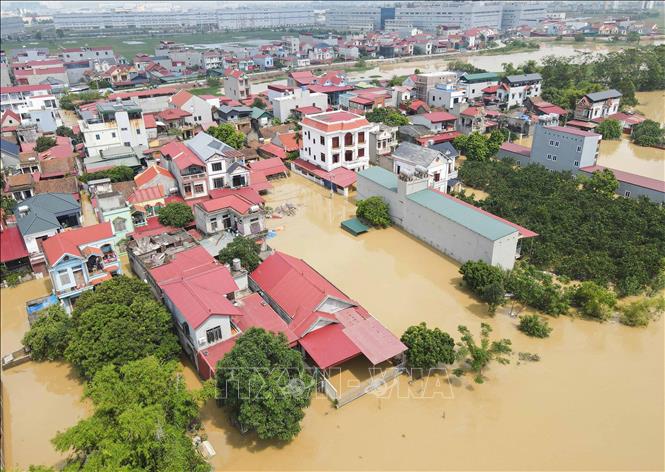
According to a report from the Bac Ninh Provincial Department of Agriculture and Environment, as of 6:00 AM on October 12th, the water level on the Cau River at K0 of the left dike (formerly Hoa Son commune) had rapidly receded by 4.5m; at K9+400 (Dai Mao village area, Hop Thinh commune) it had receded by 3.5m; and at K32+200 (at Dong Xuyen bridge) it had receded by 2.5m. At Phuc Loc Phuong, the water level is receding rapidly, having fallen below alarm level 3 by 3:00 AM on October 12th. Previously, at Dap Cau, the water level had already fallen below alarm level 3 at 11:00 PM on October 11th. On the Thuong River, at Km0 of the right dike (Cua Song village), the water level has decreased by 1.8m compared to the flood peak.
Forecast for the next 24 hours: At Phu Lang Thuong station, flood levels will drop to (6.15 - 6.25m), below alarm level 3; at Phuc Loc Phuong station, flood levels will drop to (6.55 - 6.65m), above alarm level 1.
The Department of Agriculture and Environment of Bac Ninh province warns that while water levels on the Cau and Thuong rivers continue to recede, the risk of landslides remains very high. Local authorities need to coordinate closely with dike management forces to strengthen patrols and guard the dikes to promptly address any dike-related incidents such as seepage, landslides, and damage to culverts under the dikes.
Currently, in Bac Ninh province, 3,753 households still need to relocate to safe areas; 15,333 households remain isolated, a decrease of 1,771 households compared to the afternoon of December 11th. To date, there have been no dangerous incidents threatening the safety of irrigation works, dikes, and dams from level III to level I (apart from incidents caused by heavy rain and water overflowing dikes).
The dike system is stable, with no new incidents occurring. The remaining irrigation works are basically safe, with no major incidents occurring, and are operating according to the approved system procedures. Several drainage pumping stations have resumed operation to reduce flooding in residential areas and agricultural production.
Currently, in the flooded areas of villages and residential areas including the communes/wards of Tien Luc, My Thai, Da Mai, Tan Dinh, Bac Lung, Lang Giang, Viet Yen, Van Ha, Hop Thinh, Dong Ky, Yen The, and Bo Ha, the water is still receding; the inter-village and inter-commune roads in some communes of Dong Ky, Yen The, Bo Ha, and Hop Thinh are now open. Some households in higher areas have returned to clean up.
The flooding situation in the Lai Nghien canal, Da Mai ward, has eased. Currently, the difference in water level between the fields and the river at the Da Mai sluice gate is 20 cm. Water has receded in the North-South railway area and some sections of national and provincial roads, preventing flooding. At the Duc Mai sluice gate (My Thai commune), the water level in the fields has dropped by about 1 meter, with a difference in water level between the fields and the river of about 70 cm, allowing for faster water drainage. However, the fields are still flooded to a depth of about 1.5 - 1.8 meters.
Source: https://baotintuc.vn/xa-hoi/bac-ninh-ha-muc-bao-dong-บน-song-cau-song-thuong-20251012131902239.htm


Comment (0)