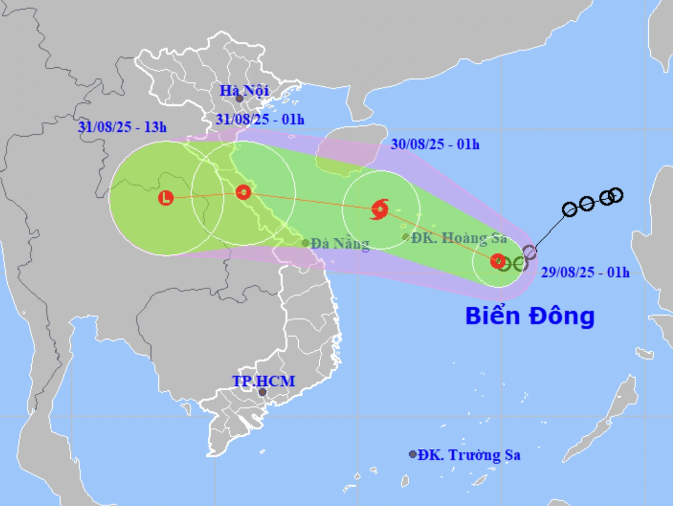
The National Center for Hydro-Meteorological Forecasting said that in the early morning of August 29, the center of a tropical depression was operating in the North East Sea, about 300km east-southeast of Hoang Sa special zone.
The strongest wind near the center of the tropical depression is level 6-7 (39-61km/h), gusting to level 9 and moving west at a speed of 10km/h.
It is forecasted that at around 1:00 a.m. on August 30, the tropical depression will likely strengthen into a storm (storm No. 6) with a strong intensity of level 8, gusting to level 10, and will operate in the sea northwest of the Hoang Sa special zone.
At that time, the North East Sea area (including Hoang Sa special zone), the North of the central East Sea area, and the offshore waters from Nghe An to Hue were affected.
According to forecasts, the storm will then move deeper into the sea and mainland of the central provinces and gradually weaken. The directly affected areas include provinces from Nghe An to Hue .
Provinces from Nghe An to Hue are likely to be affected by the upcoming storm (Photo: NCHMF).
Due to the influence of the tropical depression (which is likely to strengthen into a storm), the North East Sea area (including Hoang Sa special zone) and the sea area north of the central East Sea have strong winds of level 6-7, the area near the storm's center has strong winds of level 8, gusts of level 10, waves 3-5m high, rough seas.
From the night of August 29, the sea area from Nghe An to Hue will gradually increase to level 6-7, the area near the storm's eye will experience level 8 winds, gusting to level 10, waves 3-5m high, and rough seas.
Ships operating in the above mentioned dangerous areas are likely to be affected by storms, whirlwinds, strong winds and large waves.
During the day and night of August 30, the northwestern sea area of the East Sea (including Hoang Sa) and the sea area from Thanh Hoa to Thua Thien Hue will have winds of level 6-7, the area near the center of the tropical depression will have winds of level 8, gusting to level 9-10; rough seas; waves 3-5.0m high.
The northern Gulf of Tonkin has winds of level 6, gusting to level 8. The sea area from Khanh Hoa to Ho Chi Minh City has southwest winds of level 6, gusting to level 7-8. The central and southern East Sea (including Truong Sa) has southwest winds of level 6-7, gusting to level 8-9.
On land, from the evening and night of August 29 to August 31, the midland and delta areas of the North, from Thanh Hoa to Da Nang, will have moderate rain, heavy rain and thunderstorms ranging from 50-100mm, locally very heavy rain over 200mm, and over 350mm in some places.
According to the hydro-meteorological agency, the total rainfall from the evening and night of August 29 to August 31 in the Northern region and Da Nang is generally 100-200mm, locally over 400mm; the rain center from Thanh Hoa to Hue is generally 150-350mm, locally over 600mm.
Dantri.com.vn
Source: https://dantri.com.vn/xa-hoi/nhung-khu-vuc-nao-bi-anh-huong-boi-con-bao-du-kien-sap-hinh-thanh-20250829060829196.htm


![[Photo] President Luong Cuong receives Speaker of the New Zealand Parliament Gerry Brownlee](https://vphoto.vietnam.vn/thumb/1200x675/vietnam/resource/IMAGE/2025/8/29/7accfe1f5d85485da58b0a61d35dc10f)







![[Photo] Hanoi is ready to serve the occasion of the 80th National Day Celebration on September 2nd](https://vphoto.vietnam.vn/thumb/1200x675/vietnam/resource/IMAGE/2025/8/29/c838ac82931a4ab9ba58119b5e2c5ffe)










Comment (0)