
According to the National Center for Hydro-Meteorological Forecasting, at 1:00 a.m. on September 22, the center of super typhoon Ragasa was about 230km east-northeast of Luzon Island (Philippines).
The strongest wind near the storm center is level 16-17 (184-221km/h), gusting above level 17. The storm moves mainly in the West Northwest direction, at a speed of about 20km/h.
At 1am on September 23, super typhoon Ragasa was in the northeastern part of the East Sea. The strongest wind near the storm center was level 17, gusting above level 17.
Early the next morning, super typhoon Ragasa was in the northern part of the East Sea, about 490km east of Leizhou Peninsula (China). The storm intensity was now level 16-17, gusting above level 17.
At 1am on September 25, storm Ragasa was in the sea east of Leizhou Peninsula (China). The strongest wind near the storm center was level 14-15, gusting to level 17, with a tendency to weaken.
In the next 72-120 hours, super typhoon Ragasa will move in the West Southwest direction, about 20km per hour, and its intensity will continue to weaken.
The meteorological agency forecasts that due to the influence of super typhoon Ragasa, the northeastern sea of the East Sea will have winds gradually increasing to level 8-9, then increasing to level 10-14.
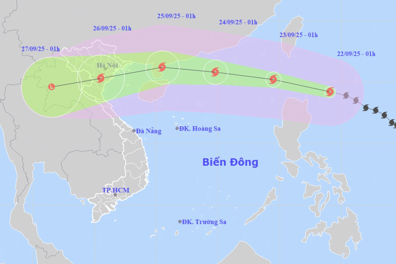
The movement of storm Ragasa (Photo: NCHMF).
The area near the center of the super typhoon will have a level 15-17 wind speed, gusting above level 17, waves over 10m high, and very rough seas. Ships in the danger zone may be affected by storms, whirlwinds, very strong winds, and very large waves.
Dr. Hoang Phuc Lam, Deputy Director of the National Center for Hydro-Meteorological Forecasting (Department of Hydro-Meteorology), said that around the evening of September 22, super typhoon Ragasa will move into the East Sea and become the 9th typhoon in the 2025 typhoon season.
The storm will then move quickly at about 20km/h, with maximum storm intensity reaching level 16-17, gusting above level 17 on September 22-23 while still in the East Sea.
According to Mr. Lam, this intensity is equivalent to the strongest intensity of storm No. 3 ( Yagi ) in 2024. On September 24, the storm is likely to weaken.
By early morning on September 25, the storm will pass the Leizhou peninsula (China) and move into the Gulf of Tonkin with a strong intensity of level 12-14, gusting to level 15-16.
Mr. Lam commented that on September 25, the storm will move inland, focusing on the area from Quang Ninh to Ha Tinh .
Dantri.com.vn
Source: https://dantri.com.vn/thoi-su/nhung-khu-vuc-nao-cua-nuoc-ta-co-the-chiu-anh-huong-cua-sieu-bao-ragasa-20250921222346659.htm


![[Photo] Prime Minister Pham Minh Chinh chairs the first meeting of the Central Steering Committee on housing policy and real estate market](https://vphoto.vietnam.vn/thumb/1200x675/vietnam/resource/IMAGE/2025/9/22/c0f42b88c6284975b4bcfcf5b17656e7)


Comment (0)