
Tonight (September 22), super typhoon Ragasa entered the northeastern sea of the North East Sea, becoming the ninth typhoon in 2025.
With a strength of 17, Ragasa has surpassed the 2024 Yagi storm (the strongest level 16) to become the strongest storm in history in the East Sea. This is also the strongest storm in the East Sea in 2025 up to this point.
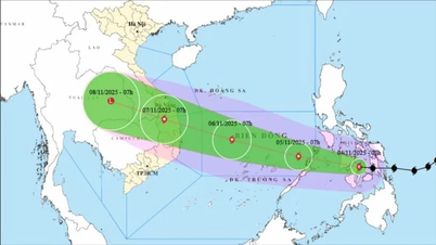
After entering the East Sea, the storm will move rapidly at a speed of about 20-25km/h and maintain a maximum intensity of level 16-17 (184-220km/h), gusting above level 17 in the next 24 hours.
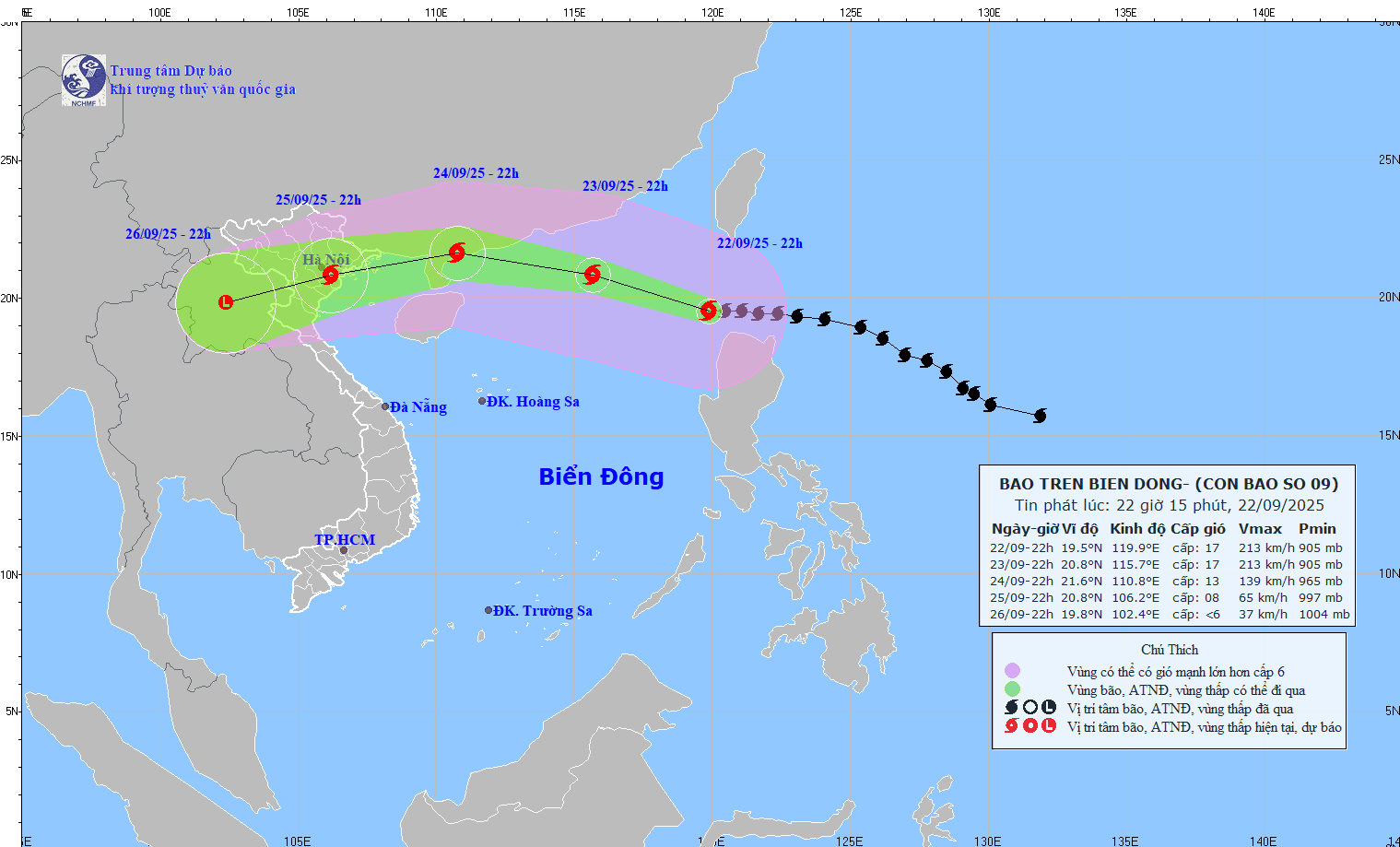
Specifically, at 10 p.m., the center of the super storm was at about 19.5 degrees North latitude; 119.8 degrees East longitude. The strongest wind near the center of the super storm was level 17 (202-221 km/h), gusting above level 17. It is forecasted that in the next 6 hours, the storm will move in a West Northwest direction, at a speed of about 20 km/h, maintaining an intensity of level 17.
As of 10 p.m. on September 23, the center of the super storm was still in the northeastern sea area of the North East Sea; intensity level 16-17, gusting above level 17.
In the next 24 hours, the storm will continue to move West Northwest, 20-25km/h and gradually weaken. By 10pm on September 24, the center of the storm will be on the mainland south of Guangzhou province (China) with winds reduced to level 12-13, gusting to level 16.
24 hours later, the storm changed direction, moving West Southwest, 20-25km/h, continuing to weaken. At 10pm on September 25, the storm's eye was on land in the area from Quang Ninh to Ninh Binh with winds of level 8, gusts of level 10.
From the next 72 to 96 hours, the storm will move in the West Southwest direction, about 20km per hour, and continue to weaken.
Due to the influence of storm No. 9 , the northern sea area of the North East Sea has strong winds of level 8-9, then increasing to level 10-14, the area near the center of the super storm has winds of level 15-17, gusts above level 17, waves over 10m high; the sea is very rough.
From September 24, the wind in the Gulf of Tonkin will gradually increase to level 6-7, then increase to level 8-10, near the storm center it will be level 11-12, gusting to level 15, waves 4-6m high; the sea will be very rough.
Ships operating in the above mentioned dangerous areas are susceptible to storms, whirlwinds, very strong winds and very large waves.
Authorities and people need to pay attention to continuously monitor and update the latest storm forecast information to proactively prepare prevention plans.
Source: https://baolamdong.vn/sieu-bao-ragasa-chinh-thuc-vao-bien-dong-thanh-bao-so-9-di-chuyen-nhanh-392696.html


![Dong Nai OCOP transition: [Article 3] Linking tourism with OCOP product consumption](https://vphoto.vietnam.vn/thumb/402x226/vietnam/resource/IMAGE/2025/11/10/1762739199309_1324-2740-7_n-162543_981.jpeg)


Comment (0)