
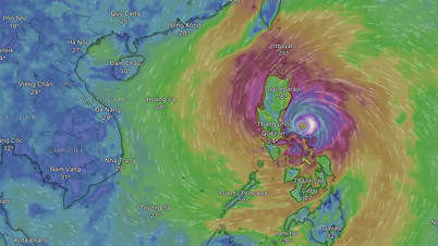
At 7:00 a.m. on November 10, the center of storm No. 14 was at about 17.4 degrees North latitude; 119.2 degrees East longitude, in the eastern sea area of the North East Sea.
The strongest wind near the storm center is level 13 (134 - 149 km/h), gusting to level 16. The storm moves in the West Northwest direction, at a speed of about 15 km/h.
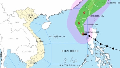
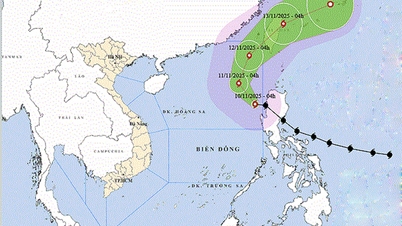
The National Center for Hydro-Meteorological Forecasting forecasts that at 7:00 a.m. on November 11, storm No. 14 will have its center at approximately 19.3°N - 117.7°E , in the eastern sea of the North East Sea. Winds will be at level 13, gusting to level 16; moving northwest at approximately 10-15km.
At 7:00 a.m. on November 12, the storm center was at about 21.8°N - 118.7°E in the northeastern sea of the North East Sea; strong winds level 13, gusts level 16. The storm moves in the North Northeast direction, speed about 10-15km/h.
By 7am on November 13, the storm may move to the northeastern coastal area of Taiwan (China) with gradually weakening intensity, strong winds of level 8, gusts of level 10.
In the next 72 - 96 hours, storm number 14 will move in the East Northeast direction, traveling 20 - 25km per hour and continue to weaken.
Due to the influence of storm No. 14, the eastern sea area of the North East Sea has strong winds of level 8-10; the area near the storm's eye has strong winds of level 11-13, gusts of level 16, waves 5-8m high, the area near the storm's eye has waves of 8-10m high; the sea is very rough.
Source: https://baophapluat.vn/bao-giat-cap-16-tren-bien-dong-tau-thuyen-can-chu-y-tranh-vung-nguy-hiem.html


![Dong Nai OCOP transition: [Article 3] Linking tourism with OCOP product consumption](https://vphoto.vietnam.vn/thumb/402x226/vietnam/resource/IMAGE/2025/11/10/1762739199309_1324-2740-7_n-162543_981.jpeg)


Comment (0)