

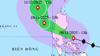
Forecast of the location and direction of storm Phuong Hoang at 4:00 a.m. on November 10 (Photo: VNDMS)
According to the National Center for Hydro-Meteorological Forecasting at 4am this morning, typhoon Phuong Hoang is in the eastern sea of the northern East Sea. The strongest wind near the storm's center is level 13 (134-149km/h), gusting to level 16.
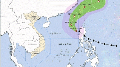
According to the meteorological agency, after entering the East Sea, the subtropical pressure branch in the north of the storm's guiding current weakened in intensity and expanded further south of the storm.
This leads to the storm tending to move more to the north. As it moves to higher latitudes, the storm will enter the guiding flow of the upper westerly wind zone, so it is likely to change direction to the northeast and move out of the East Sea.
Specifically, today and tonight, the storm is forecast to move northwest at a speed of about 10-15km/h, with little chance of changing its intensity.
At 4am tomorrow morning (November 11), the storm center will be in the eastern sea area of the northern East Sea, with storm intensity remaining at level 13, gusting to level 16.
During tomorrow day and night, the storm will change direction to the northeast at a speed of about 10-15km/h.
At 4:00 a.m. on November 12, the storm's eye was over the northeastern sea area of the northern East Sea, with storm intensity still at level 13, gusting to level 16.
The storm then continued northeastward, passing Taiwan and gradually weakening.
"Usually at the end of the season, storms often move west, even west-southwest, and make landfall in the southern central provinces.
However, typhoon Phuong Hoang moved north and out into the East Sea. This is the unusual point of this storm" - the National Center for Hydro-Meteorological Forecasting commented.
Thus, with the current forecast, typhoon Phuong Hoang is unlikely to affect our mainland.
Due to the influence of the storm, in the eastern sea area of the northern East Sea today there will be strong winds of level 8-10, near the eye of the storm there will be strong winds of level 11-13, gusts of level 16, waves 5-8m high, near the eye of the storm 8-10m.
All vessels operating in the above-mentioned dangerous areas are susceptible to the impact of storms, whirlwinds, strong winds and large waves./.
According to Tuoi Tre Newspaper
Source: https://tuoitre.vn/bao-phuong-hoang-vao-bien-dong-tro-thanh-con-bao-so-14-20251110055657037.htm
Source: https://baolongan.vn/bao-phuong-hoang-vao-bien-dong-tro-tha-nh-con-ba-o-so-14-a206149.html


![Dong Nai OCOP transition: [Article 3] Linking tourism with OCOP product consumption](https://vphoto.vietnam.vn/thumb/402x226/vietnam/resource/IMAGE/2025/11/10/1762739199309_1324-2740-7_n-162543_981.jpeg)


Comment (0)