
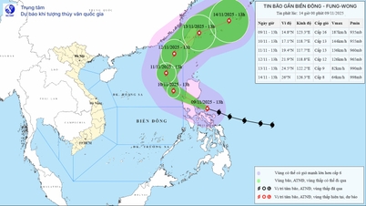
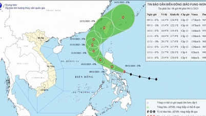
The National Center for Hydro-Meteorological Forecasting (NCHMF) said: At 1:00 a.m. today (November 9), the center of storm Fung Wong was at about 13.7 degrees north latitude and 126.4 degrees east longitude. The strongest wind near the center of the storm is level 15 (167 - 183 km/h), gusting to level 17. Moving west-northwest at a speed of about 30 km/h, about to make landfall in the Philippines.

Storm Fung Wong reaches maximum intensity, about to enter the East Sea as storm number 14 (SOURCE: NCHMF)
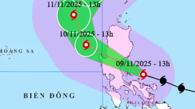
At 1:00 a.m. on November 10, in the Luzon Island area of the Philippines, storm Fung Wong was at level 14 with gusts of level 17 and continued to move at a speed of 25 - 30 km/h. Then, it entered the northeastern area of the East Sea and became storm number 14. At 1:00 a.m. on November 11, storm number 14 weakened to level 13 with gusts of level 16, and its moving speed also decreased to 10 - 15 km/h.
After entering the East Sea, Typhoon Fung Wong changed direction and moved more to the north. As it moved to higher latitudes, the storm entered the upper westerly wind flow, so it was likely to change direction to the northeast and move out of the East Sea towards Taiwan.
Thus, typhoon Fung won’t reach the level of super typhoon as previously forecasted but its development is unusual. Normally, at the end of the season, typhoons often move west, even west-southwest and make landfall in the southern central provinces. However, typhoon Fung won’t move north and go out, this is the unusual point of this typhoon.
Due to the influence of storm No. 14 (Fung Wong), the sea area east of the northern East Sea has strong winds of level 6 - 7, later increasing to level 8 - 10; the area near the storm center has strong winds of level 11 - 13, gusts of level 16, waves 4 - 6 m high, later increasing to 6 - 8 m, the area near the storm center is 8 - 10 m. The sea is very rough.
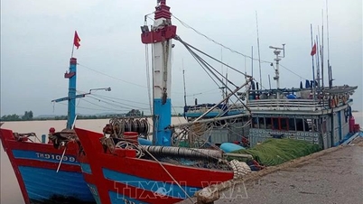
Warning: During November 10-12, the eastern sea area of the northern East Sea is likely to be affected by strong storm winds of level 11-13, gusts of level 16, waves of 8-10 m high, and rough seas. All boats operating in the above-mentioned dangerous areas are likely to be affected by storms, whirlwinds, strong winds, and large waves.
In addition, the sea area from Ca Mau to An Giang and the Gulf of Thailand will have scattered showers and thunderstorms, with the possibility of tornadoes and strong gusts of wind./.
According to Thanh Nien Newspaper
Source: https://thanhnien.vn/bao-fung-wong-dat-cuong-do-cuc-dai-bien-dong-song-cao-den-10-m-18525110906534425.htm
Source: https://baolongan.vn/bao-fung-wong-dat-cuong-do-cuc-dai-bien-dong-song-cao-den-10-m-a206110.html


![[Infographic] Vietnam's stock market exceeds 11 million trading accounts](https://vphoto.vietnam.vn/thumb/402x226/vietnam/resource/IMAGE/2025/11/09/1762677474332_chungkhoanhomnay0-17599399693831269195438.jpeg)


![Dong Nai OCOP transition: [Part 2] Opening new distribution channel](https://vphoto.vietnam.vn/thumb/402x226/vietnam/resource/IMAGE/2025/11/09/1762655780766_4613-anh-1_20240803100041-nongnghiep-154608.jpeg)


Comment (0)