

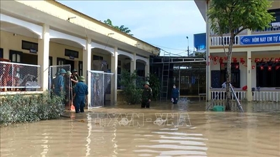
Telegrams sent to the People's Committees of coastal provinces and cities from Quang Ninh to Dak Lak; Ministries of National Defense, Agriculture and Environment, Public Security, Construction, Foreign Affairs, Science and Technology; Vietnam News Agency, Vietnam Television, Voice of Vietnam .
According to the National Center for Hydro-Meteorological Forecasting, early on the morning of November 10, storm Fung-wong entered the eastern sea area of the North East Sea, becoming storm number 14 in 2025.
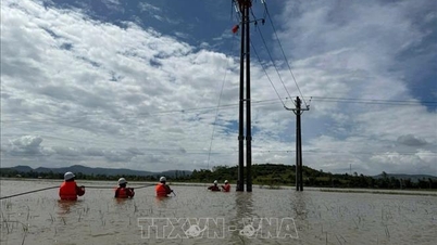
To proactively respond to the storm, the National Steering Committee for Civil Defense requested ministries, branches and People's Committees of coastal provinces and cities from Quang Ninh to Dak Lak to closely monitor the storm's developments; strictly manage vessels going out to sea; organize counting and notify owners of vessels and captains of ships and boats operating at sea of the location, direction of movement and developments of the storm to proactively avoid, escape or not move into dangerous areas. Dangerous areas in the next 24 hours: latitude 15.0 - 21.0 degrees North; East of longitude 116.0 degrees East (dangerous areas are adjusted in forecast bulletins).
Ministries, sectors and localities are ready with forces and means for rescue when required. Ministries and sectors, according to their functions, state management tasks and assigned tasks, proactively direct and coordinate with localities to respond to the storm.
Vietnam News Agency, Vietnam Television, Voice of Vietnam, the coastal information station system and mass media agencies from central to local levels should increase information about the storm's developments to authorities at all levels, owners of vehicles operating at sea and people to proactively respond.
The above units organize serious duty and regularly report to the National Civil Defense Steering Committee (through the Department of Dyke Management and Natural Disaster Prevention and Control - Ministry of Agriculture and Environment ).
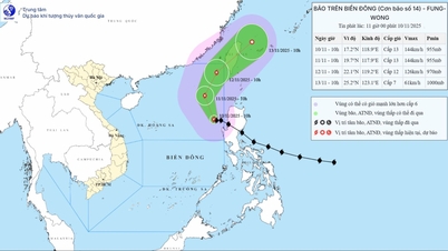
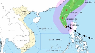
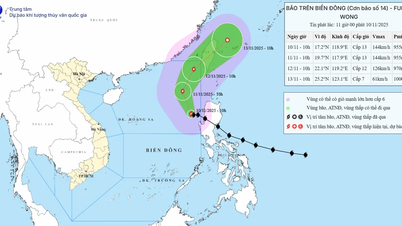
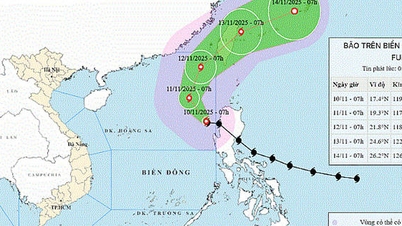
According to the National Center for Hydro-Meteorological Forecasting, at 10:00 a.m. on November 10, the center of the storm was located at about 17.2 degrees North latitude; 118.9 degrees East longitude, in the eastern sea area of the North East Sea. The strongest wind near the center of the storm was level 13 (134-149 km/h), gusting to level 16. Moving in the West Northwest direction, speed about 15 km/h.
Forecast, by 10:00 on November 11, storm No. 14 is in the eastern sea of the North East Sea with wind speed of level 13, gusting to level 16. The storm is moving in the North Northwest direction, speed of 10-15 km/h. The affected area is the eastern sea of the North East Sea, disaster risk level is level 3.
At 10:00 a.m. on November 12, the storm was in the northeastern sea of the North East Sea with winds of level 12, gusts of level 15. The storm moved in the North Northeast direction, at a speed of 10-15 km/h. The affected area was the eastern sea of the North East Sea, with a disaster risk level of level 3.
Then, at 10:00 a.m. on November 13, the storm was in the northeastern coastal area of Taiwan (China), with the strongest wind at level 7, gusting to level 9 and gradually weakening. The storm moved northeast at a speed of 20 km/h. The affected area was the northeastern sea area of the North East Sea, with a disaster risk level of level 3.
Due to the impact of the storm, the eastern sea area of the North East Sea has strong winds of level 8-10; the area near the eye of the storm has strong winds of level 11-13, gusts of level 16, waves 5-8m high, the area near the eye of the storm is 8-10m. The sea is very rough.
All boats operating in the above mentioned danger zones are susceptible to storms, whirlwinds, strong winds and large waves.
Source: https://baotintuc.vn/thoi-su/chi-dao-ung-pho-bao-so-14-tren-bien-dong-20251110123914365.htm


![Dong Nai OCOP transition: [Article 3] Linking tourism with OCOP product consumption](https://vphoto.vietnam.vn/thumb/402x226/vietnam/resource/IMAGE/2025/11/10/1762739199309_1324-2740-7_n-162543_981.jpeg)


Comment (0)