
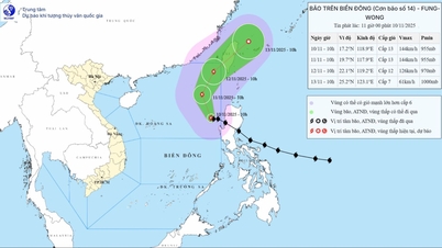
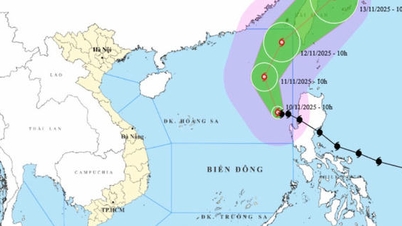
Updated information from the National Center for Hydro-Meteorological Forecasting, as of 11:00 a.m. on November 10, the center of storm No. 14 was at coordinates of approximately 17.2 degrees North latitude - 118.9 degrees East longitude, in the eastern sea of the North East Sea. The strongest wind near the center of the storm was at level 13 (134-149 km/h), gusting to level 16.

From now until November 13, the storm will continuously change direction, moving in turn to the Northwest, then to the Northeast and Northeast, with a speed gradually increasing from 10 to 20 km/hour, operating mainly in the eastern and northeastern waters of the North East Sea, then gradually weakening as it moves towards the northeastern area of Taiwan.
Although the storm's eye did not go deep into the East Sea, it still caused very dangerous weather in the northern East Sea area.
On the morning of November 10, the National Civil Defense Steering Committee issued a telegram to 13 coastal provinces and cities from Quang Ninh to Dak Lak , along with relevant ministries, requesting them to closely monitor the storm's developments, manage and notify vessels going out to sea, prepare rescue forces, and strengthen information and propaganda to proactively respond to storm No. 14.
Source: https://www.sggp.org.vn/de-nghi-13-dia-phuong-huong-dan-tau-thuyen-tranh-bao-so-14-post822738.html


![[Photo] Prime Minister Pham Minh Chinh attends the Patriotic Emulation Congress of the Ministry of Foreign Affairs for the 2025-2030 period](https://vphoto.vietnam.vn/thumb/1200x675/vietnam/resource/IMAGE/2025/11/10/1762762603245_dsc-1428-jpg.webp)
![[Photo] Prime Minister Pham Minh Chinh attends the annual Vietnam Business Forum](https://vphoto.vietnam.vn/thumb/1200x675/vietnam/resource/IMAGE/2025/11/10/1762780307172_dsc-1710-jpg.webp)


![Dong Nai OCOP transition: [Article 3] Linking tourism with OCOP product consumption](https://vphoto.vietnam.vn/thumb/402x226/vietnam/resource/IMAGE/2025/11/10/1762739199309_1324-2740-7_n-162543_981.jpeg)


Comment (0)