

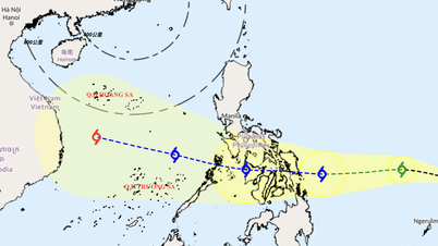
Forecast of location and direction of super typhoon Ragasa at 10:00 p.m. on September 22 - Photo: NCHMF
According to the National Center for Hydro-Meteorological Forecasting at 10:00 p.m. on September 22, super typhoon Ragasa entered the northeastern sea of the northern East Sea, becoming the ninth typhoon in 2025.
Currently, the storm intensity is still maintained at level 17 (202-221km/h), gusting above level 17.
At the meeting to respond to super typhoon Ragasa organized by the Ministry of Agriculture and Environment on the evening of September 22, Mr. Mai Van Khiem, Director of the National Center for Hydro-Meteorological Forecasting, said that through the analysis of satellite structure, the cross-section through the center of the storm has a very strong convective cloud area around the storm, high cloud tops, cloud top temperatures of -70 to -80 degrees Celsius.
The eye of the storm is clear, hot, and has a temperature above 15 degrees Celsius (hot center). The larger the difference between the cloud top temperature around the eye of the storm and the temperature in the eye of the storm, the stronger the storm.
Storm clouds are developing, showing no signs of decreasing below level 17 in the next 6 hours and likely to maintain level 16-17 intensity on September 23.
Mr. Khiem also said that currently in the north, there is a continental high pressure - a dry air mass with humidity of 30-40% - that is developing towards the north of our country. Therefore, the dry air mass is one of the factors that can weaken super typhoon Ragasa in the coming days.
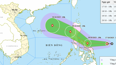
Second, in the next 2-3 days, Ragasa storm is forecast to move mainly in the west-northwest direction, so the storm is likely to approach the southern mainland of Guangdong province (China), the storm will begin to weaken. After that, the storm will change direction to move in the west-southwest direction, pass through Leizhou peninsula, enter the Gulf of Tonkin and affect our country around September 25.

Mr. Mai Van Khiem, Director of the National Center for Hydro-Meteorological Forecasting, commented on the potential impact of super typhoon Ragasa on our country - Photo: C. TUE
Regarding the storm's impact area, Mr. Khiem said that due to the influence of the storm's circulation in the northern area of the East Sea, the wind is strong at level 8-9, then increases to level 10-14, the area near the storm's center is level 15-17, gusts above level 17, waves over 10m high, and the sea is very rough.
High waves in Vietnam sea area
From September 24, the sea area of Bac Bo Gulf will have strong storm winds of level 8, near the storm center level 11-13, gusting to level 15-16. In the offshore area of Bac Bo Gulf (including Bach Long Vy special zone), waves will be 2-4m high, near the storm center waves will be 5-7m high.
Coastal waters of Quang Ninh - Thanh Hoa provinces (including Van Don, Co To and Cat Hai special economic zones) have waves 2-4m high.
On land, according to Mr. Khiem, with the current forecast, the strongest wind area from Quang Ninh to Thanh Hoa is likely to be directly affected by the storm with strong winds near the storm center at level 9-11, gusting at level 14, deeper inland at level 6-7, gusting at level 9-10. The strongest wind time is from morning to night of September 25.
"If the storm moves further north (travels more over land), the impact of the wind on the Gulf of Tonkin and the mainland will be less dangerous," said Mr. Khiem.
Regarding heavy rain, Mr. Khiem said that in the North, from Thanh Hoa to Ha Tinh, there is a possibility of widespread rain from 70-150mm.
Rainy areas in Thai Nguyen, Southern Tuyen Quang, Lao Cai, Phu Tho, and the Northern Delta will see 150-250mm of rain, locally over 450mm. Rain will concentrate from the night of September 24 to 26.
"Rain forecasts can still be adjusted, so people need to follow updated storm bulletins, especially when the storm enters the 115th meridian (the area north of Hoang Sa archipelago), when forecasts will be more reliable," said Mr. Khiem.
Weather forecast for the night of September 22-23: Super typhoon Ragasa enters the East Sea, heavy rain nationwide
Source: https://tuoitre.vn/sieu-bao-ragasa-da-vao-bien-dong-du-bao-tac-dong-doi-voi-viet-nam-20250922220701121.htm

![[Photo] "Ship graveyard" on Xuan Dai Bay](https://vphoto.vietnam.vn/thumb/1200x675/vietnam/resource/IMAGE/2025/11/08/1762577162805_ndo_br_tb5-jpg.webp)


![[Video] Hue Monuments reopen to welcome visitors](https://vphoto.vietnam.vn/thumb/402x226/vietnam/resource/IMAGE/2025/11/05/1762301089171_dung01-05-43-09still013-jpg.webp)


Comment (0)