

On the afternoon of November 1, the Department of Hydrometeorology ( Ministry of Agriculture and Environment ) informed that Vietnam's meteorological agency had made an initial assessment of the possibility of storm No. 13 appearing in the East Sea.
Specifically, according to the National Center for Hydro-Meteorological Forecasting, there is currently an active tropical depression in the eastern part of the Philippines, located at approximately 9.9 degrees North latitude and 138.4 degrees East longitude. According to current data, the National Center for Hydro-Meteorological Forecasting believes that tonight to tomorrow morning (November 2), the tropical depression is likely to strengthen into a storm.

Around November 5, the storm will enter the East Sea and become storm number 13. The National Center for Hydro-Meteorological Forecasting warns that this is a strong storm in the East Sea, the strongest when the storm enters the Truong Sa special zone (may be stronger than level 12).
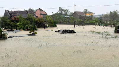
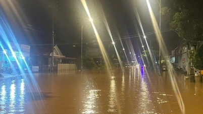
Around November 7, the storm will move into the mainland of our country, the focus area that needs to be noted that is likely to be directly affected is from Da Nang City to Khanh Hoa Province. The storm can cause strong winds and heavy rain in the provinces of the Central Central, South Central, and Central Highlands regions from the night of November 6 to November 9.
The meteorological agency also noted that the storm has not yet formed and is still affected by many factors in the coming days as well as the impact of terrain when it makes landfall in the Philippines, so scenarios on the intensity, direction of movement as well as areas directly affected by storm No. 13 still need to be monitored and updated with new observation and forecast data.
Source: https://www.sggp.org.vn/bien-dong-va-mien-trung-co-the-hung-con-bao-so-13-post821245.html


![[Photo] Prime Minister Pham Minh Chinh chairs the second meeting of the Steering Committee on private economic development.](https://vphoto.vietnam.vn/thumb/1200x675/vietnam/resource/IMAGE/2025/11/01/1762006716873_dsc-9145-jpg.webp)


Comment (0)