
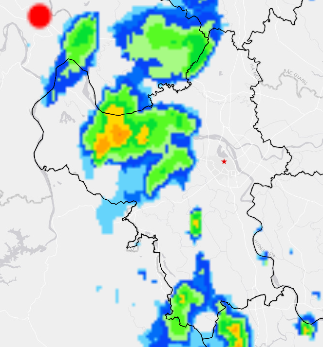
Through monitoring on satellite images and weather radar images, it shows that convective clouds are developing over the Hanoi capital area including Thanh Oai and Binh Minh. This cloud area has a tendency to expand further.
Warning: From 11am to 3-4 hours from now, the above mentioned areas will have showers and thunderstorms, then expanding to the wards: Yen Nghia, Phu Luong, Kien Hung, Ha Dong and other inner city areas of Hanoi. During thunderstorms, there is a possibility of tornadoes, lightning and strong gusts of wind.
Warning level of natural disaster risk due to tornado, lightning, hail: Level 1.
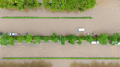
Also on October 1, the Hanoi City Civil Defense Command (Command) said that due to the impact of storms and rains, the water level in the Bui River, Nhue River, Day River, Ca Lo River... has increased in recent days. The Command has issued flood warnings on many rivers, specifically:
Level III flood warning on Bui River in communes of Xuan Mai, Phu Nghia, Tran Phu, Quang Bi, Hoa Phu, Phuc Son.
Level II flood warning on Nhue River in the following communes and wards: Thuong Cat, Dong Ngac, Phu Dien, Tu Liem, Xuan Phuong, Tay Mo, Dai Mo, Ha Dong, Kien Hung, Dai Thanh, Binh Minh, Ngoc Hoi, Tam Hung, Thuong Tin, Thuong Phuc, Dan Hoa, Phuong Duc, Chuyen My and Ung Hoa.
Level I flood alert on Ca Lo River in the communes of Soc Son, Da Phuc, Thu Lam, Phuc Thinh, Quang Minh, Tien Thang and Noi Bai.
Level I flood warning on Cau River in the communes of Trung Gia and Da Phuc; level III flood warning on Bui River in the communes of Xuan Mai, Phu Nghia, Tran Phu, Quang Bi, Hoa Phu and Phuc Son.
The Command Committee requested localities, relevant units and people to strictly follow regulations when there is a flood warning, proactively prepare plans to ensure safety of life and property, especially in riverside and low-lying areas.
According to the forecast of the Northern Hydrometeorological Station, on October 1, the water level of rivers flowing through the city will continue to rise. In particular, the flood level of Bui River can reach 7.25m (exceeding the level III flood warning by 0.25m), the area along Bui River is at risk of flooding with a depth of 0.2-0.5m, some places are flooded deeper than 0.5m, lasting for 2-3 days; level 2 flood disaster risk level.
Source: https://cand.com.vn/Xa-hoi/noi-thanh-ha-noi-co-the-xuat-hien-dong-loc-trong-vai-gio-toi-i783192/
![[Photo] Keep your warehouse safe in all situations](https://vphoto.vietnam.vn/thumb/1200x675/vietnam/resource/IMAGE/2025/10/1/3eb4eceafe68497989865e7faa4e4d0e)
![[Photo] Hanoi morning of October 1: Prolonged flooding, people wade to work](https://vphoto.vietnam.vn/thumb/1200x675/vietnam/resource/IMAGE/2025/10/1/189be28938e3493fa26b2938efa2059e)


![[Photo] President of the Cuban National Assembly visits President Ho Chi Minh's Mausoleum](https://vphoto.vietnam.vn/thumb/1200x675/vietnam/resource/IMAGE/2025/10/1/39f1142310fc4dae9e3de4fcc9ac2ed0)


![[Infographics] An Giang Agriculture 2020-2025: Stable growth, quality transformation](https://vphoto.vietnam.vn/thumb/402x226/vietnam/resource/IMAGE/2025/10/1/bf3a77ba3a0243a697e5253ed4cd6f9c)


Comment (0)