
The meteorological agency issued the latest bulletin on storm Matmo and said the storm is moving quickly, possibly reaching level 12 in the East Sea, heading towards the Gulf of Tonkin.
News of storm Matmo near the East Sea
The National Center for Hydro-Meteorological Forecasting said, Typhoon Matmo Gets stronger at level 9, moves fast at 25km/h and can max out at level 12.
Accordingly, at 1:00 a.m. on October 3, the center of storm Matmo was located in the sea east of Luzon Island (Philippines). The strongest wind near the center of the storm was level 9 (75-88 km/h), gusting to level 11, moving in the West Northwest direction, at a speed of about 25 km/h.
That same evening, storm Matmo entered the East Sea, becoming the 11th storm of the year.
It is forecasted that by 1am on October 4, storm Matmo will move in a West-Northwest direction, traveling about 25km per hour, with the possibility of strengthening. The center of the storm is located in the eastern sea of the North East Sea with a level 10 intensity, gusting to level 12.
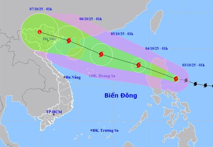
At 1:00 a.m. on October 5, storm No. 11 Matmo in the northwest sea of the North East Sea, about 340km east-southeast of Leizhou Peninsula (China), continued to move rapidly in the West-Northwest direction, at a speed of 20-25km/h, possibly strengthening with the strongest wind near the storm center at level 12, gusting to level 15.
At about 1:00 a.m. on October 6, storm No. 11 Matmo in the Northern Gulf of Tonkin moved in the West Northwest direction, at a speed of 20-25 km/h and decreased by 1 level with the strongest wind near the storm center at level 11, gusting to level 14.
From the next 72 to 120 hours, the storm will move in the West Northwest direction, traveling 15-20km per hour, and the storm's intensity will gradually decrease.
Impact of storm Matmo, from noon and afternoon of October 3, the sea area east of the North East Sea will gradually increase to level 6-7, then increase to level 8-9, the area near the storm center will have strong level 10-11, gusting to level 13, waves 4-6m high, rough seas.
Around October 4-5, the northern sea area of the North East Sea is likely to be affected by strong winds of level 11-12, gusting to level 15.
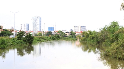
Believe flood emergency on the rivers
Currently, floods on the Lo River (Tuyen Quang), Thuong River (Bac Ninh) and the downstream of the Ca River (Nghe An) continue to recede slowly. At 7:00 p.m. on October 2, floods on the Cau River (Bac Ninh) peaked at 6.52m, 0.22m above alert level 3; floods on the Thai Binh River (Hai Phong) peaked at 5.09m, 0.09m above alert level 2.
Water level at 1:00 a.m. on October 3 on Lo River at Tuyen Quang station was 25.78m, 0.22m below BĐ3; on Cau River at Dap Cau station was 6.50m, 0.20m above BĐ3; on Thuong River at Phu Lang Thuong station was 6.10m, 0.20m below BĐ3; on Thai Binh River at Pha Lai station was 5.05m, 0.05m above BĐ2; on Ca River at Nam Dan station was 7.11m, 0.21m above BĐ2.
It is forecasted that in the next 6 hours, the flood on Cau River will slowly recede and be above level 3. In the next 12 hours, the flood on Cau River will continue to recede and be below level 3; on Lo River and Thuong River will recede and be above level 2; on Thai Binh River and downstream of Ca River will slowly recede and be below level 2.
In the next 12-24 hours, flood on Cau River will continue to fall and below level 3; Lo River and Thuong River will fall slowly, above level 2; flood on Thai Binh River will continue to fall, above level 1; flood in the downstream of Ca River will fall below level 2.
In the next 36 hours, flood on Thai Binh River will continue to slowly recede and stay above level 1.
In addition, in the next 24 hours, flood on Luc Nam River ( Bac Ninh ) at Luc Nam station will drop to level 1.
Source: https://baolangson.vn/tin-bao-matmo-moi-nhat-di-chuyen-nhanh-manh-cap-12-tren-bien-dong-5060694.html


![[Photo] Prime Minister Pham Minh Chinh chairs meeting to deploy overcoming consequences of storm No. 10](https://vphoto.vietnam.vn/thumb/1200x675/vietnam/resource/IMAGE/2025/10/3/544f420dcc844463898fcbef46247d16)
![[Photo] Students of Binh Minh Primary School enjoy the full moon festival, receiving the joys of childhood](https://vphoto.vietnam.vn/thumb/1200x675/vietnam/resource/IMAGE/2025/10/3/8cf8abef22fe4471be400a818912cb85)


Comment (0)