
Flood water in Cau River and Ca Lo River in Hanoi reaches its peak tonight.
On the evening of October 9, the Department of Hydrometeorology ( Ministry of Agriculture and Environment ) said that the water level on the Cau River and Ca Lo River in the Hanoi area continued to rise.
At 5:00 p.m., Cau River at Luong Phuc station reached 10.12m, 2.12m higher than alarm level 3, while Ca Lo River at Manh Tan station reached 9.65m, about 1.65m higher than alarm level 3.
It is forecasted that in the next 12 to 24 hours, the water level on these two rivers may peak on the night of October 9 and early morning of October 10, then slowly decrease.
Currently, high water levels are causing flooding in low-lying areas, alluvial plains and riverside residential areas with an average depth of 0.2 - 0.6m, even over 0.6m in some places. The flooding is expected to last from 2 - 4 days, seriously affecting people's daily life and traffic.
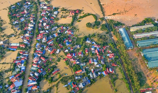
Hanoi evacuated more than 6,500 people from dangerous areas
Faced with rapidly rising floodwaters, the People's Committee of Da Phuc commune (Soc Son district, Hanoi) issued an urgent notice, requesting people to immediately evacuate from dangerous areas.
Local authorities said the flood from upstream to the Cau River was very strong, causing about 5km of the main dike to be deeply submerged, many sections outside the dike were flooded. At the same time, the railway line breaking incident through Trung Gia commune increased the risk of flooding in areas inside the dike.
The Commune People's Committee requested people not to stay in dangerous areas, and to raise their property, move livestock, poultry and valuable equipment to safe places. Local forces have been mobilized to assist people in evacuating, especially in deeply flooded areas along the river.
According to the Da Phuc Commune Civil Defense Command, as of the evening of October 9, the commune had evacuated more than 6,500 people to safety. Shelters were arranged at schools, medical stations, cultural houses and high ground, ensuring temporary living conditions.
Mobilizing more than 10,000 people to reinforce the dike, preventing the risk of breaking the right bank of the bridge.
The heavy flood situation caused the right dike of Cau Bridge to overflow about 7.5 km (from K18+500 to K26+000) with an overflow height of 0.1 - 0.3 m. In addition, two landslides at K17+700 and K8+270 and the phenomenon of erupting at K24+300 Cam Ha village continued to cause concern.
On the night of October 8, Da Phuc commune mobilized more than 10,600 people, including 600 military officers and soldiers, along with many vehicles, to reinforce the dike and prevent landslides.
The forces have covered with waterproof tarpaulins, inserted sandbags and placed warning signs at dangerous points to prevent the risk of dike breaches. Currently, the units still maintain 100% of their personnel on duty at 7 key areas along the level III dike.
Traffic affected, water overflowed onto Hanoi - Thai Nguyen highway
The flood also affected traffic on the Hanoi - Thai Nguyen Expressway. A representative of the Road Traffic Police Team No. 15 (Hanoi Police Traffic Police Department) confirmed that water had overflowed onto the road surface at Km29, passing through Trung Gia commune, with a depth of about 20cm and a length of more than 100m.
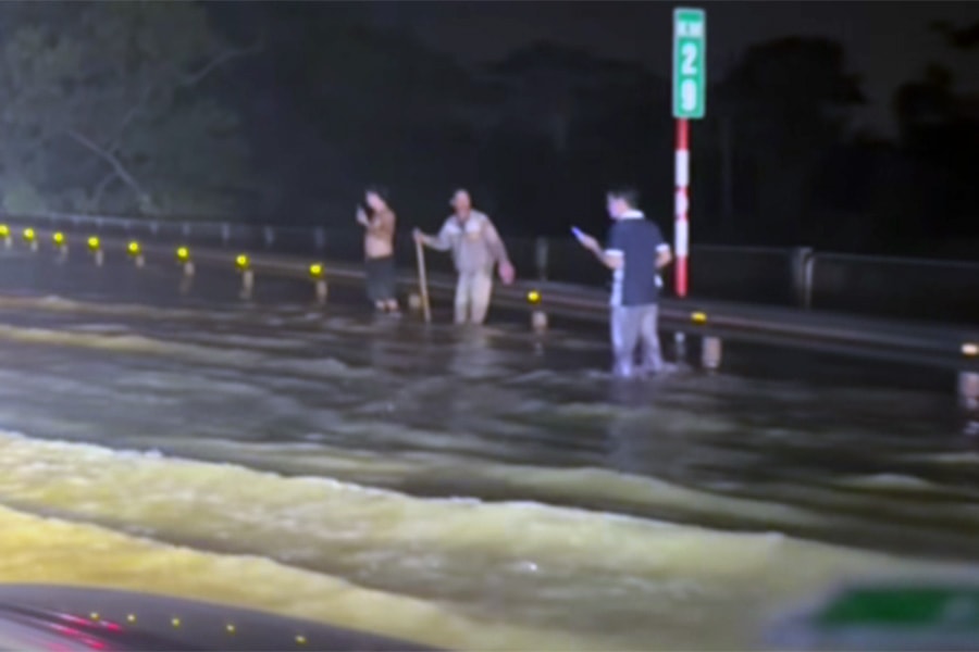
Traffic police have been directing and regulating traffic, and advised drivers to reduce speed and follow instructions when passing through this area.
Although the flood level is not too high, the rapid rise in water level can increase the risk of traffic congestion and accidents, especially at night.
Hanoi maintains flood alert level 3, closely monitors river water levels
According to the Hanoi City Civil Defense Command, from 8:20 p.m. on October 7, the city issued a level 3 flood warning on the Cau River, passing through Trung Gia and Da Phuc communes.
Then, at 1:10 a.m. on October 8, Hanoi also issued a level 3 flood warning on the Ca Lo River, through Soc Son, Da Phuc, Thu Lam, Phuc Thinh, Quang Minh, Tien Thang and Noi Bai.
By October 9, the water level of the Ca Lo River peaked at 8.5m, causing many low-lying areas in Soc Son, Da Phuc, Trung Gia and Thu Lam to be deeply flooded.
Tan Hung, Cam Ha II, Tang Long and Tien Tao pumping stations are operating at full capacity to drain water, reducing pressure on the dike system and residential areas.
Source: https://baonghean.vn/tin-lu-ha-noi-ha-noi-di-doi-hon-6500-nguoi-dan-khoi-vung-nguy-hiem-10307958.html
![[Photo] Prime Minister Pham Minh Chinh chairs a meeting of the Government Standing Committee on overcoming the consequences of natural disasters after storm No. 11](https://vphoto.vietnam.vn/thumb/1200x675/vietnam/resource/IMAGE/2025/10/09/1759997894015_dsc-0591-jpg.webp)

![[Photo] President Luong Cuong attends the 80th Anniversary of the Traditional Day of Vietnamese Lawyers](https://vphoto.vietnam.vn/thumb/1200x675/vietnam/resource/IMAGE/2025/10/09/1760026998213_ndo_br_1-jpg.webp)

![[Photo] General Secretary To Lam visits Kieng Sang Kindergarten and the classroom named after Uncle Ho](https://vphoto.vietnam.vn/thumb/1200x675/vietnam/resource/IMAGE/2025/10/09/1760023999336_vna-potal-tong-bi-thu-to-lam-tham-truong-mau-giao-kieng-sang-va-lop-hoc-mang-ten-bac-ho-8328675-277-jpg.webp)


Comment (0)