Tay Ninh is a province in the Southeast region of Vietnam, with a natural area of 4,035.45 km² and a population of approximately 1,064,000 people.
Geographical location: The province currently has 9 administrative units, including Tay Ninh City and 8 districts. Tay Ninh City is the economic, political , and cultural center of the province, located 99 km northwest of Ho Chi Minh City along National Highway 22.
Tay Ninh province is located in the Southern key economic region; to the west and north, it borders the Kingdom of Cambodia with a 240 km long border, including 2 international border gates (Moc Bai, Xa Mat), 4 main border gates, and 10 sub-border gates; to the east, it borders Binh Duong and Binh Phuoc provinces; to the south, it borders Ho Chi Minh City and Long An province. The Moc Bai international border gate is 70 km from Ho Chi Minh City and 100 km from Phnom Penh, Cambodia. Tay Ninh has important transportation routes such as the Trans-Asian Highway and National Highway 22B; ...
Topography: Tay Ninh's topography is relatively flat, with good engineering geology and soil mechanical properties, making foundation construction less expensive and highly favorable for the development of agriculture, industry, trade, services, tourism, and infrastructure.
Climate: Tay Ninh has a relatively mild climate, divided into two distinct seasons: the rainy season and the dry season. The average annual rainfall is 1800-2200 mm, and the average annual humidity is around 70-80%.
Tay Ninh is influenced by two main types of wind: westerly-southwesterly winds during the rainy season and northerly-northeasterly winds during the dry season. Wind speeds average 1.7 m/s and blow moderately throughout the year. The average annual temperature in Tay Ninh is 27.4 ° C, with abundant sunshine year-round, averaging up to 6 hours of sunshine per day. Furthermore, Tay Ninh is less affected by typhoons, floods, and other adverse weather conditions. The climate of Tay Ninh is very favorable for the development of diverse agriculture, especially industrial crops, fruit trees, medicinal plants, and large-scale livestock and poultry farming.
Land resources: there are 5 main soil groups with 15 different soil types.
+ Gray soil group (comprising 6 types) covers an area of 339,833 hectares, accounting for approximately 84.4% of the province's natural area and distributed throughout the province. This type has a light mechanical composition, is easily drained, and is suitable for many types of crops.
+ Acid sulfate soils (comprising 3 types) cover a total area of 25,359 hectares, accounting for 6.3% of the natural area, mainly distributed in Chau Thanh, Go Dau, and Trang Bang districts.
+ The red-yellow soil group (comprising 3 types) accounts for a small proportion, about 1.6% of the natural area, mainly distributed in Tan Bien and Tan Chau districts. This type of soil can be used for forestry development.
+ Alluvial soils (comprising 2 types) account for 0.4% of the natural area, formed by the sedimentation of rivers, making them suitable for growing rice and vegetables.
+ The buried peat soil group has a very small area, accounting for only 0.3% of the province's natural area. It is mainly distributed in Ben Cau and Chau Thanh districts… This type of soil is very acidic, both in the surface and peat layers, with a pH of 2-3. It has a very high organic matter content, but poor decomposition.
Water resources: Tay Ninh's surface water resources mainly rely on the activity of two major rivers: the Saigon River and the Vam Co Dong River.
Mineral resources: Tay Ninh has potential in several types of minerals used as construction materials, including minerals for cement production, which many provinces in the region lack; clay for bricks and tiles, stone, and construction sand, which some surrounding provinces have limited resources for. The reserves of these construction materials are quite large and of good quality.
Culture and tourism potential: Tay Ninh possesses many potentials to develop almost all types of tourism, such as:
+ Mount Ba Den – the highest mountain in Southern Vietnam, situated in the middle of the plain, holds a beautiful story of loyalty and high spiritual value. It is a pilgrimage and sightseeing destination attracting over 2 million visitors annually. Here, you'll find mysterious caves, treacherous paths to the summit, and the heroic history of a resistance base… providing a foundation for developing various forms of tourism, including exploration, adventure, and heritage tourism. Ma Thien Lanh area, a valley nestled between three mountains, boasts a cool climate, making it an ideal location for a high-end resort and entertainment complex.
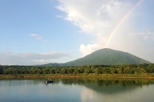
Ba Den Mountain
Tay Ninh is a province rich in revolutionary traditions. The Tay Ninh forest served as the base for the Central Committee of the Southern Region, the leading agency of the Southern revolution. The Tua Hai area is associated with the historic victory linked to the Dong Khoi movement. The Duong Minh Chau war zone was the launching point of the National Liberation Front of the South… In addition, Tay Ninh has many other landmarks associated with the resistance against foreign invaders, such as the Boi Loi base and the An Thoi tunnels… Historical tourism has great potential for development.
The Cao Dai Holy See is the center of Cao Daiism, a religion that originated in Tay Ninh in 1926. With its unique architecture, culturally significant ceremonial music, and major festivals in January and August, the Tay Ninh Holy See is a unique feature of Tay Ninh that attracts millions of domestic and international tourists every year.
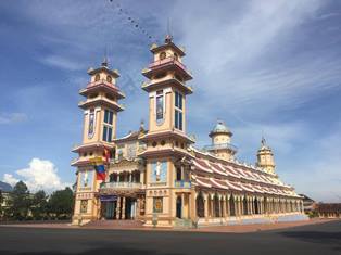
Tay Ninh Holy See
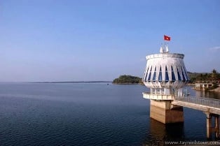
+ Dau Tieng Lake, covering 27,000 hectares, with Nhim Island spanning 340 hectares, is an ideal location for an international-class eco-tourism, resort, and entertainment complex.
The Lo Go - Xa Mat National Park, located 40 km from Tay Ninh town, covers an area of 18,765 hectares and boasts high biodiversity value. It is home to many animal and plant species listed in the Vietnamese Red Book. Therefore, it is very suitable for developing ecotourism and scientific research.
Tay Ninh occupies a crucial position connecting Ho Chi Minh City with popular tourist destinations in Cambodia: from Ho Chi Minh City to Phnom Penh via the Moc Bai border gate is about 170 km, and to Siem Reap via the Xa Mat border gate is about 400 km. Therefore, connecting and creating tours between Tay Ninh and other provinces and cities in Vietnam, as well as with Cambodia and other countries by road, has great potential for development.
Tay Ninh has the potential to develop almost all types of tourism, including resort, eco-tourism, spiritual, and entertainment tourism. However, its tourism infrastructure and services are still underdeveloped and in the early stages of completion, therefore many great opportunities await domestic and foreign investors to explore and implement their unique ideas.
Provincial e-Government Portal

![[Photo] The heat at the fireworks display site on the opening night of the Da Nang International Fireworks Festival 2026](https://vphoto.vietnam.vn/thumb/1200x675/vietnam/resource/IMAGE/2026/05/27/1779889741485_ndo_br_z7872039145157-fecaba5112f39e8352544099d7ef4738-5140-jpg.webp)


![[Photo] The courage of new recruits of Brigade 144 on the training ground.](https://vphoto.vietnam.vn/thumb/1200x675/vietnam/resource/IMAGE/2026/05/27/1779881651341_anh-man-hinh-2026-05-27-luc-18-32-52.png)


![[Photo] The courage of new recruits of Brigade 144 on the training ground.](https://vphoto.vietnam.vn/thumb/402x226/vietnam/resource/IMAGE/2026/05/27/1779881651341_anh-man-hinh-2026-05-27-luc-18-32-52.png)


Comment (0)