

Telegrams sent to the People's Committees of coastal provinces and cities from Quang Ninh to Lam Dong; Ministries of National Defense, Public Security, Agriculture and Environment, Construction, Industry and Trade, Foreign Affairs, Science and Technology; Vietnam News Agency, Vietnam Television, Voice of Vietnam .
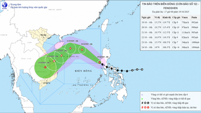
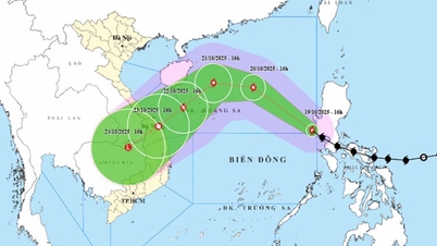
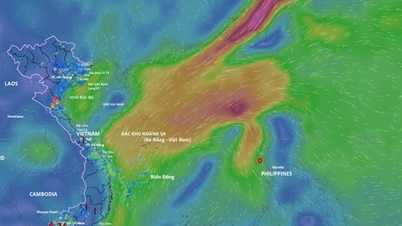
Accordingly, on the afternoon of October 19, storm FENGSHEN entered the East Sea as storm No. 12 in 2025. At 7:00 p.m. on October 19, the center of the storm was at about 15.6 degrees North latitude; 119.0 degrees East longitude, about 750 km East Southeast of Hoang Sa special zone. The strongest wind near the center of the storm was level 9 (75-88 km/h), gusting to level 11. Moving northwest at a speed of about 25 km/h. The storm is forecast to strengthen in the next 24 hours.
Closely monitor storm developments to proactively respond.
To proactively respond to the storm, the National Steering Committee for Civil Defense recommends that ministries, branches and People's Committees of coastal provinces and cities from Quang Ninh to Lam Dong : closely monitor the storm's developments; strictly manage vessels going out to sea; organize counting and notify owners of vessels and captains of ships and boats operating at sea of the location, direction of movement and developments of the storm to proactively avoid, escape or not move into dangerous areas. Dangerous areas in the next 24 hours: From latitude 15.0 - 20.5N; east of longitude 113.5E (dangerous areas are adjusted in forecast bulletins).
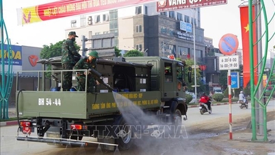
Ministries, sectors and localities are ready with forces and means for rescue when required. Ministries and sectors, according to their functions, state management tasks and assigned tasks, proactively direct and coordinate with localities to respond to the storm.
Vietnam News Agency, Vietnam Television, Voice of Vietnam, the coastal information station system and mass media agencies from central to local levels should increase information about the storm's developments to authorities at all levels, owners of vehicles operating at sea and people to proactively respond.
The above units organize serious duty and regularly report to the National Civil Defense Steering Committee (through the Department of Dyke Management and Natural Disaster Prevention and Control - Ministry of Agriculture and Environment).
Beware of flash floods and landslides in Da Nang city
Along with that, the National Center for Hydro-Meteorological Forecasting forecasts that from 9:40 p.m. on October 19 to 2:40 a.m. on October 20, the Da Nang city area will continue to have rain with accumulated rainfall ranging from 20-60 mm, in some places over 100 mm.
There is a risk of flash floods on small rivers and streams, landslides on steep slopes in the above province, especially in the communes and wards of Hiep Duc, Phuoc Tra, Que Son, Que Son Trung, Son Cam Ha, Viet An; Dong Duong, Duy Xuyen, Kham Duc, Nong Son, Phuoc Chanh, Phuoc Hiep, Phuoc Nang, Phuoc Thanh, Que Phuoc, Tam My, Tay Ho, Thang An, Thang Binh, Thang Phu, Thanh Binh, Tien Phuoc, Tra Leng, Tra Lien, Xuan Phu.
Warning level of natural disaster risk due to flash floods, landslides, land subsidence due to heavy rain or level 1 flow.
Flash floods and landslides can have very negative impacts on the environment, threaten people's lives; cause local traffic congestion, affect the movement of vehicles; destroy civil and economic works, causing damage to production and socio-economic activities.
The hydrometeorological agency recommends that local authorities pay attention to reviewing bottlenecks and vulnerable locations in the area to have prevention and response measures.
From 6:00 p.m. to 8:00 p.m. on October 19, Da Nang city had moderate to heavy rain such as: Que Son 77.4mm, Cay Thong Lake junction 72mm, Binh Lam 55.6mm...
Soil moisture models show that some areas in the province are near saturation (over 85%) or have reached saturation.
Source: https://baotintuc.vn/xa-hoi/tu-quang-ninh-den-lam-dong-chu-dong-ung-pho-bao-so-12-20251019214107148.htm


Comment (0)