
 |
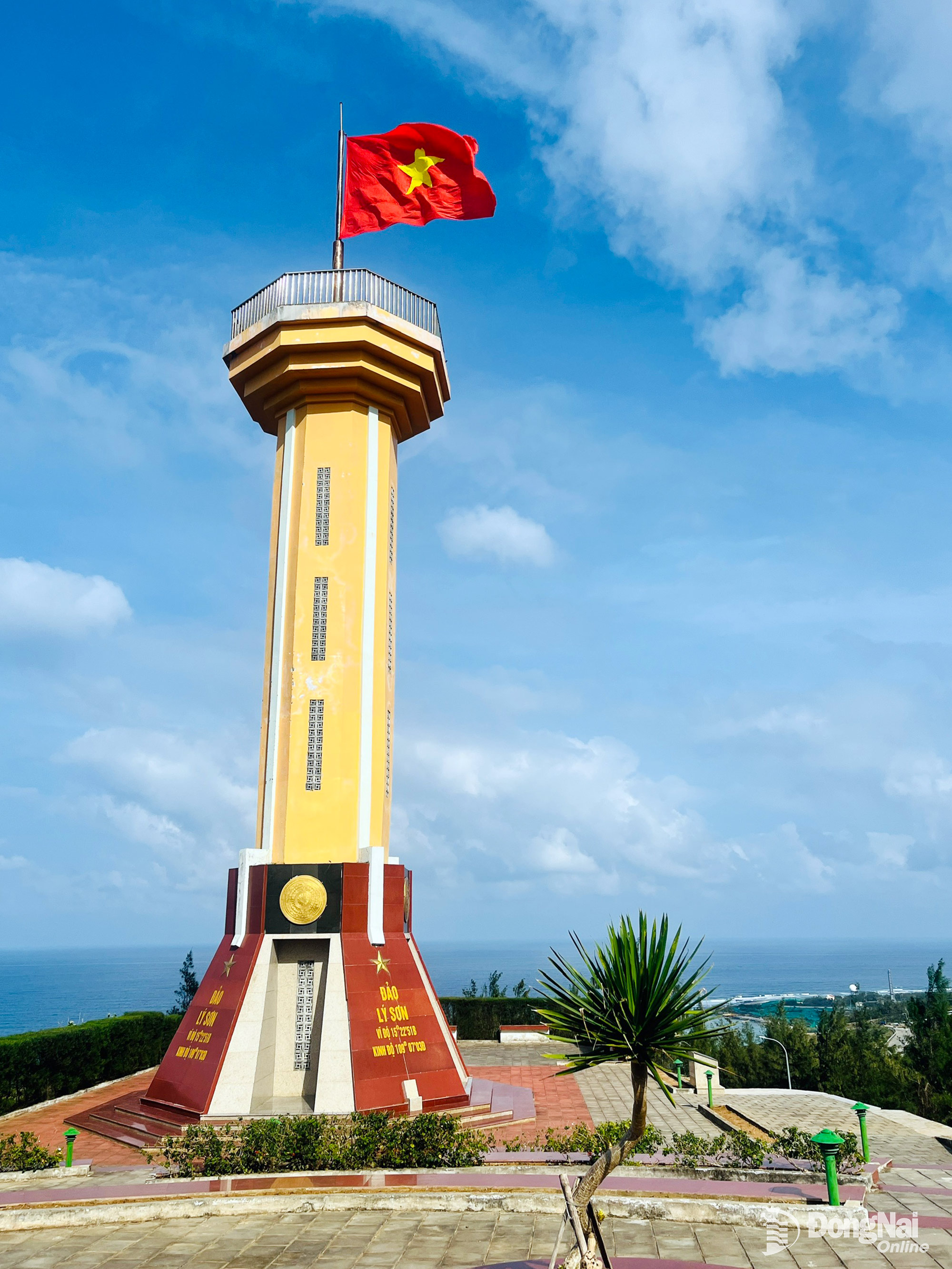
| The flag flies proudly atop Thoi Loi mountain, Ly Son. Photo: Thuy Trang |
Having long harboured the intention, during the upcoming Lunar New Year of the Horse 2026, Mr. Manh Cuong (from Ho Nai ward, Dong Nai province) and his friends embarked on a motorbike trip covering nearly 800km from Dong Nai to Sa Ky Port, Quang Ngai province, and then a 45-minute speedboat ride to reach Ly Son Special Economic Zone. “The long journey was tiring for me and my companions, but it was truly worthwhile. During our two days and one night in Ly Son, I captured many beautiful moments, and I'm sure I'll miss this beautiful island region when I return,” Mr. Cuong said.
Affirming the sacred sovereignty of the Fatherland's seas and islands.
The Hoang Sa and Bac Hai Fleet Exhibition House is located near Ben Dinh Port in the Ly Son Special Economic Zone. Visitors are immediately impressed by the statue of the Hoang Sa and Bac Hai Fleet, depicting three soldiers with their faces looking straight ahead and their hands pointing east. Behind them is an embossed inscription: "The Hoang Sa archipelago is of paramount importance to the nation's maritime territory" - Minh Mang 17th year, Binh Than year 1836 (meaning: the Hoang Sa archipelago is of extremely strategic importance to the country's territorial waters).
The exhibition houses a collection of valuable maps and documents affirming Vietnam's sovereignty over the Hoang Sa and Truong Sa archipelagos. The maps and documents displayed at this exhibition are copies from the archives of the National Border Committee (Ministry of Foreign Affairs ), the Da Nang Institute for Economic and Social Development Research, and a collection of maps donated to the Da Nang Institute for Economic and Social Development Research by engineer Tran Thang, a Vietnamese expatriate in the United States, in 2012-2013. These maps and documents are displayed according to five themes, affirming that the Vietnamese state has explored, established, exercised, and protected its sovereignty over the Hoang Sa and Truong Sa archipelagos for a very long time, beginning with the Nguyen dynasty establishing the Hoang Sa fleet to exploit resources in these islands in the 16th century, officially possessing the two archipelagos in the 17th-18th centuries, and continuing to the Nguyen dynasty sending people to survey waterways, erect sovereignty markers, and create maps to affirm Vietnam's sovereignty over these two archipelagos and other islands in the East Sea in the 19th century. Vietnam's exploration, establishment, and exercise of sovereignty over the Hoang Sa and Truong Sa archipelagos have also been acknowledged by Western navigators, geographers, merchants, and others. Official Chinese maps published by the Chinese state from the feudal era until the mid-20th century all confirm that Chinese territory only extends to the southernmost point of Hainan Island, having no connection to Vietnam's Hoang Sa and Truong Sa archipelagos (which China calls Xisha and Nansha), and indirectly acknowledge Vietnam's sovereignty over these two archipelagos.
Even today, when visiting Ly Son Island, the locals still pass down this folk verse:
The Paracel Islands are a vast expanse of sky and sea.
Those who left never returned.
The Paracel Islands are surrounded by clouds and water on all sides.
In February, a feast is held to honor the soldiers who served in the Paracel Islands.
The Hoàng Sa Soldiers' Memorial Ceremony dates back to ancient times, featuring a model of a fishing boat with ancestral tablets and effigies of Hoàng Sa soldiers, conveying the hope that these spirit boats will bear all risks in place of the Hoàng Sa soldiers.
Amazed by the magnificent nature
Mount Thoi Loi stands out prominently on the island's landscape with its stacked rock formations. This volcano erupted approximately 11 million years ago. After climbing the steep slope, visitors are moved to admire the sturdy national flag pole with the red flag bearing a yellow star fluttering in the wind. Following another winding, steep path, visitors are surprised to find a freshwater reservoir at the summit, a former volcanic crater. From above, one can easily see a panoramic view of Ly Son Island, with residential areas and lush green garlic fields below.
Hang Cau appears with its layers of stacked cliffs, along with caves at the foot of the mountain carved quite deep by nature, looking rather precarious but having survived for countless years. The combination of clear blue sea water and rocky cliffs against a clear blue sky creates an unforgettable impression for visitors.
Not far away is Hang Pagoda, also known as Thien Khong Thach Tu (Heavenly Stone Pagoda), with Chinese characters carved into the cliff face. This national historical and cultural site was once recorded in the Dai Nam Nhat Thong Chi (Comprehensive Gazetteer of Dai Nam) by the National History Institute of the Nguyen Dynasty. Hang Pagoda originated as a temple of the Champa people, dedicated to Brahman gods. Later, when the Vietnamese came to settle the Ly Son area in the early 17th century, the pagoda became a place of asceticism and later a Buddhist temple. What is special is that for centuries, a cool, clear stream of fresh water has continuously trickled down from the mountaintop, a meaningful gift for the locals and visitors.
 |
| Tò Vò Gate, a famous check-in spot. |
Ly Son also captivates tourists from near and far with many famous check-in points such as: To Vo Gate, Xo La Well, Be Island..., a rich history and culture such as the Hoang Sa Soldiers' Commemoration Ceremony, the custom of worshipping the Whale God..., and a unique and attractive culinary scene with dishes like: king crab, barracuda, young garlic salad, seaweed salad, xoa xoa sweet soup... As a native of Quang Ngai who studied and worked in the South, Mr. Ngoc Minh (from Nghia Lo ward, Quang Ngai province) shared: “I really want to promote the image of my homeland, the people of Quang Ngai in general, and the Ly Son Special Economic Zone in particular, to domestic and international tourists. This Tet holiday, I invited and brought my friends and colleagues to Ly Son to visit, admire, and experience Ly Son - a sea and island region with great tourism potential.”
Thuy Trang
Source: https://baodongnai.com.vn/dong-nai-cuoi-tuan/202602/an-tuong-dao-ngoc-ly-son-fc0230e/


![[Video] Sunset at Lap An Lagoon – Where the sun sets over the fishing nets](https://vphoto.vietnam.vn/thumb/340x192/vietnam/resource/IMAGE/2026/05/31/1780192137701_beach-landscape-sea-water-nature-grass-745871-pxhere-com.jpeg)


![[Photo] The General Secretary, President and his wife lay flowers at the Ho Chi Minh Monument in Manila.](https://vphoto.vietnam.vn/thumb/1200x675/vietnam/resource/IMAGE/2026/05/31/1780219759477_anh-man-hinh-2026-05-31-luc-16-29-07.png)


Comment (0)