According to the Philippine Atmospheric, Geophysical and Astronomical Services Administration (PAGASA) storm bulletin, at 2:00 AM local time on September 26, the center of the low-pressure system (09:00) was located at approximately 16.4 degrees North latitude and 148.0 degrees East longitude, 2,475 km east-northeast of Eastern Visayas, outside the Philippine Forecast Area (PAR).
PAGASA forecasts a high probability of the low-pressure system strengthening within the next 24 hours.
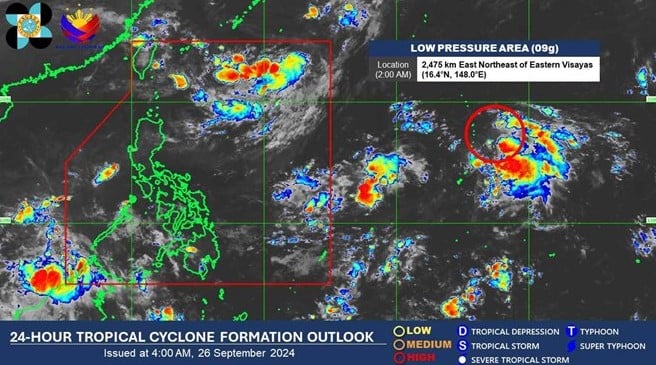
Location of the low-pressure center near the Philippines at 2:00 AM on September 26, 2024. Photo: PAGASA/Lao Dong Newspaper
PAGASA weather forecaster Rhea Torres indicated that the low-pressure system could move closer to the northernmost point of Luzon on Friday (September 27) or Saturday (September 28).
Meanwhile, PAGASA's weather forecast bulletin at 4:00 AM on September 26th indicated that the intertropical convergence zone was affecting Palawan, Visayas, and Mindanao.
Cloudy skies with scattered showers or thunderstorms are forecast for the Bicol region, Northern Samar, Eastern Mindoro, Marinduque, and Romblon. Light to moderate winds from the northeast to east will prevail, with calm to moderate seas.
Also in its storm forecast for September 25th, PAGASA stated that during the week from September 25th to October 1st, two low-pressure systems are expected to form: Low-pressure system 1 east of the Tropical Cyclone Advisory Domain (TCAD) and Low-pressure system 2 north of the PAR. Both low- to moderate intensity systems are likely to strengthen.
During the week of October 2-8, Low Pressure System 3 is located within the PAR (Paracel Islands), potentially moving into the South China Sea, with the possibility of strengthening from low to moderate intensity.
Meanwhile, Low Pressure System 4 is located at the northern boundary of the PAR, with the potential to intensify significantly.
The Philippines regularly faces around 20 typhoons and tropical storms each year, especially during the rainy season which lasts from June to November or December.
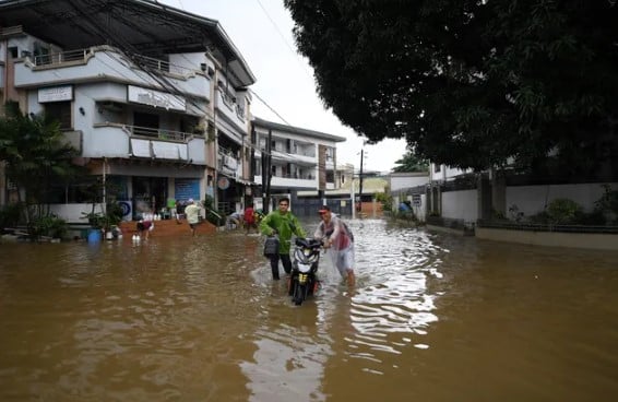
A street is flooded after heavy rains caused by Typhoon Yagi in a village in Cainta town, Rizal province, east of Manila, Philippines, on September 3 (Photo: AFP/VTV)
Earlier in September, Typhoon Yagi struck several areas of the Philippines, killing 16 people, injuring 15, and leaving 21 others missing, according to a report by the Philippine National Disaster Risk Reduction and Management Council. The fatalities from Typhoon Yagi were due to landslides or drowning.
Meanwhile, infrastructure damage is estimated at around $4 million. Infrastructure damage was recorded in areas affected by flooding, landslides, or collapses caused by heavy rain and strong winds.
Typhoon Yagi made landfall in the Philippines on the evening of September 1st, causing flooding and landslides in many areas before leaving the country on September 3rd. Yagi became a super typhoon after leaving the Philippines.
Minh Hoa (compiled from Lao Dong newspaper and VTV)
Source: https://www.nguoiduatin.vn/ap-thap-gan-philippines-kha-nang-cao-manh-len-trong-24-gio-toi-204240926081339894.htm










![[OFFICIAL] MISA GROUP ANNOUNCES ITS PIONEERING BRAND POSITIONING IN BUILDING AGENTIC AI FOR BUSINESSES, HOUSEHOLDS, AND THE GOVERNMENT](https://vphoto.vietnam.vn/thumb/402x226/vietnam/resource/IMAGE/2025/12/11/1765444754256_agentic-ai_postfb-scaled.png)














Comment (0)