

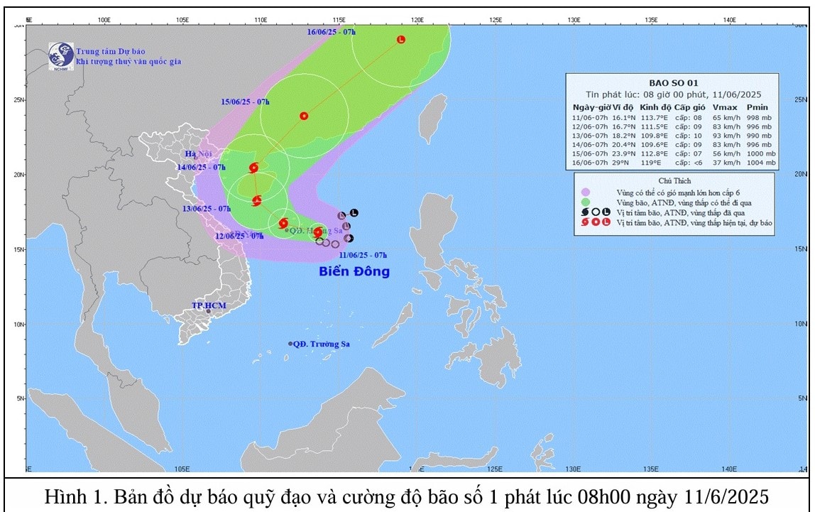
At 7:00 a.m. this morning, June 11, the center of the storm was at about 16.1 degrees North latitude; 113.7 degrees East longitude in the sea east of Hoang Sa archipelago. The strongest wind near the center of the storm was level 8 (62-74 km/h), gusting to level 10; the storm moved slowly in the West-Northwest direction at a speed of about 5-10 km/h.
It is forecasted that by 7am tomorrow, June 12, the storm will move in a West-Northwest direction, over the Hoang Sa archipelago, at a speed of about 10 km/h and is likely to strengthen, with wind intensity of level 9, gusting to level 11. The affected area is the North East Sea (including the Hoang Sa archipelago).
At 7:00 a.m. on June 13, the storm moved northwest, in the southern area of Hainan Island (China), at a speed of about 5-10 km/h and was likely to strengthen. Winds near the center of the storm were at level 10, gusting to level 13. The affected area was the northern East Sea (including the Hoang Sa archipelago) and the offshore waters from Quang Tri to Quang Ngai, and the eastern waters of the Gulf of Tonkin.
From the next 72 to 120 hours, the storm moved in the North Northeast direction then changed to the Northeast direction at about 20km per hour.
Affected by storm No. 1, the North East Sea area (including the Hoang Sa archipelago), the north of the central East Sea area has thunderstorms and strong winds of level 6-7, the area near the storm's center has winds of level 8-9, gusts of level 11, waves 3-5m high, very rough seas.
In the south of the central East Sea and the southern East Sea (including the waters of the Truong Sa archipelago), there will be strong southwest winds of level 6, sometimes level 7, gusting to level 8-9, waves 2-4m high, and rough seas. Ships operating in the above-mentioned dangerous areas are likely to be affected by storms, whirlwinds, strong winds, and large waves.
Quang Nam sea area in the next 24 hours will have scattered showers and thunderstorms, during thunderstorms need to be careful of tornadoes, lightning and strong gusts of wind, West to Northwest wind level 4-5, normal sea, waves from 0.5-1.5m high. From this afternoon, June 11, the wind will gradually increase to level 5, some places level 6, gusting to level 7, rough sea, waves 1.5-2.5m high.
The provincial Hydrometeorological Station requests to notify ships operating in the above sea area to take preventive measures.
Source: https://baoquangnam.vn/ap-thap-nhiet-doi-manh-len-thanh-con-bao-dau-tien-cua-nam-2025-3156473.html

![[Photo] People eagerly lined up to receive special publications of Nhan Dan Newspaper](https://vphoto.vietnam.vn/thumb/1200x675/vietnam/resource/IMAGE/2025/8/30/53437c4c70834dacab351b96e943ec5c)


Comment (0)