
According to the National Center for Hydro-Meteorological Forecasting, as of 7:00 a.m. this morning (October 2), the center of storm Matmo was located in the sea east of the Philippines. The strongest wind near the center of the storm was level 8 (62-74 km/h), gusting to level 10. The storm moved west-northwest at a speed of 15-20 km/h.
At 1:00 a.m. on October 4, the storm moved west-northwest at a speed of 25 km/h, entered the East Sea and strengthened, reaching level 10, gusting to level 12. The dangerous area in the East Sea during this period is from latitude 15°N to 21°N, east of longitude 117°E. The disaster risk level is determined at level 3.
In the next 48-72 hours, the storm will continue moving West Northwest, about 25 km per hour and is likely to strengthen.
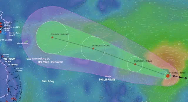
From the afternoon of October 3, the northeastern sea area of the East Sea will have winds gradually increasing to level 6-7, then increasing to level 8; near the storm center, winds will be level 9-10, gusting to level 12. Waves will be 4-6 m high, and the sea will be very rough.
Between October 4 and 6, the North East Sea area (including Hoang Sa special zone) is likely to be affected by strong winds of level 11-12, gusting to level 15.
Fishermen and boat owners should closely monitor storm bulletins and avoid operating in dangerous areas. Coastal localities should urgently review prevention and avoidance plans and be ready to respond when the storm enters the East Sea.
It is forecasted that from October 5 to 7, the northern and north central provinces are likely to experience widespread heavy rain.
Source: https://cand.com.vn/Xa-hoi/bao-matmo-giat-cap-12-di-vao-bien-dong-i783285/


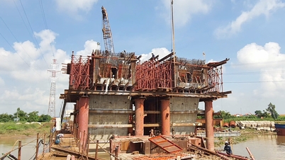
![[Photo] Binh Trieu 1 Bridge has been completed, raised by 1.1m, and will open to traffic at the end of November.](https://vphoto.vietnam.vn/thumb/1200x675/vietnam/resource/IMAGE/2025/10/2/a6549e2a3b5848a1ba76a1ded6141fae)


Comment (0)